|
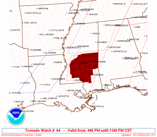
Initial List of Counties in SPC Tornado Watch 64 (WOU)
|
Back to Watch 64
|
 |
   WOUS64 KWNS 022244
   WOU4

   BULLETIN - IMMEDIATE BROADCAST REQUESTED
   TORNADO WATCH OUTLINE UPDATE FOR WT 64
   NWS STORM PREDICTION CENTER NORMAN OK
   445 PM CST FRI MAR 2 2012

   TORNADO WATCH 64 IS IN EFFECT UNTIL 1100 PM CST FOR THE
    FOLLOWING LOCATIONS

   MSC023-029-031-035-049-061-065-067-069-073-075-077-079-085-089-
   091-099-101-121-123-127-129-030500-
   /O.NEW.KWNS.TO.A.0064.120302T2245Z-120303T0500Z/

   MS
   .    MISSISSIPPI COUNTIES INCLUDED ARE

   CLARKE               COPIAH              COVINGTON
   FORREST              HINDS               JASPER
   JEFFERSON DAVIS      JONES               KEMPER
   LAMAR                LAUDERDALE          LAWRENCE
   LEAKE                LINCOLN             MADISON
   MARION               NESHOBA             NEWTON
   RANKIN               SCOTT               SIMPSON
   SMITH


   ATTN...WFO...JAN...
|
| Aviation Watch (SAW) for WW64 |
|---|
 |
| Note:
The Aviation Watch (SAW) product is an approximation to the watch area.
The actual watch is depicted by the shaded areas. |
   SAW4
   WW 64 TORNADO MS 022245Z - 030500Z
   AXIS..65 STATUTE MILES EAST AND WEST OF LINE..
   55NW MEI/MERIDIAN MS/ - 45WSW PIB/PINE BELT MS/
   ..AVIATION COORDS.. 55NM E/W /44NW MEI - 13ESE MCB/
   HAIL SURFACE AND ALOFT..2 INCHES. WIND GUSTS..60 KNOTS.
   MAX TOPS TO 500. MEAN STORM MOTION VECTOR 25035.

   LAT...LON 32888830 31208893 31209112 32889054

   THIS IS AN APPROXIMATION TO THE WATCH AREA.  FOR A
   COMPLETE DEPICTION OF THE WATCH SEE WOUS64 KWNS
   FOR WOU4.
|
|


