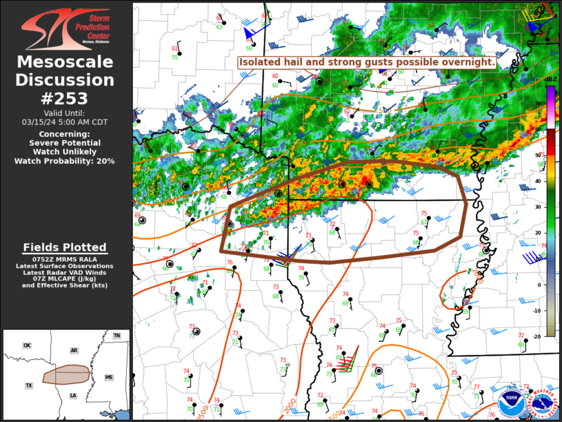
   Mesoscale Discussion 0253
   NWS Storm Prediction Center Norman OK
   0253 AM CDT Fri Mar 15 2024

   Areas affected...Northeast TX...Southern AR...Northern LA

   Concerning...Severe potential...Watch unlikely

   Valid 150753Z - 151000Z

   Probability of Watch Issuance...20 percent

   SUMMARY...Isolated hail and strong gusts possible overnight.

   DISCUSSION...A strong storm with some supercell characteristics has
   recently developed in Union County, AR, along the eastern fringe of
   extensive elevated convection ongoing near the ArkLaTex and
   ArkLaMiss regions. While this particular cell will soon be undercut
   by southward-sagging outflow, an additional strong storm or two
   could evolve from near the LA/AR border to northeast TX, within a
   low-level warm advection regime. For storms that can become rooted
   near the surface, MLCAPE in excess of 1500 J/kg and effective shear
   of 30-40 kt will support some storm organization, with a threat for
   isolated hail and strong/damaging gusts. The KSHV VWP depicts rather
   strong low-level shear/SRH, and a brief tornado cannot be ruled out
   with any cell that can become surface-based. However, in general,
   the longevity of any organized storms is expected to be relatively
   limited, and any severe threat likely to be remain mostly isolated
   overnight.

   ..Dean/Thompson.. 03/15/2024

   ...Please see www.spc.noaa.gov for graphic product...

   ATTN...WFO...JAN...LZK...SHV...

   LAT...LON   32929492 33279395 33519312 33519243 33439175 33319144
               32959132 32529142 32359180 32279260 32219341 32239388
               32339506 32929492
|


 @NWSSPC