|
| Mesoscale Discussion 289 |
|
< Previous MD Next MD >
|
|
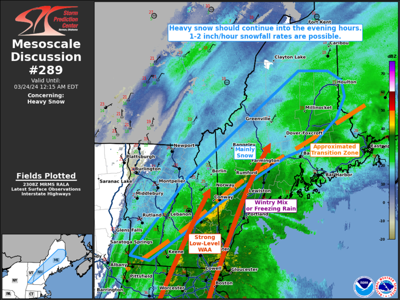
   Mesoscale Discussion 0289
   NWS Storm Prediction Center Norman OK
   0610 PM CDT Sat Mar 23 2024

   Areas affected...portions of central Vermont and New Hampshire into
   central Maine

   Concerning...Heavy snow

   Valid 232310Z - 240415Z

   SUMMARY...Heavy snow should continue across northern parts of New
   England into the evening hours. 1-2 inch/hr snowfall rates and
   periods of reduced visibility are possible, especially after 00Z (8
   PM EDT).

   DISCUSSION...Heavy snow is ongoing to the north of a strong
   low-level cyclone that is currently traversing the Atlantic
   Coastline. Regional dual-polarimetric radar data depicts the
   transition line between all snow and mixed wintry precipitation to
   be established from roughly the MA/VT border to central Penobscot
   County, ME, and the latest high-resolution model guidance suggests
   that this transition line should remain roughly stationary into the
   evening hours. 700 mb frontogenesis is increasing along the
   international border in tandem with increasing low-level WAA, and
   this should encourage increased snowfall rates as moisture and lift
   are boosted within the dendritic growth zone. 1-2 inch/hr snowfall
   rates are possible, especially later this evening (i.e. the 00-05Z
   time frame).

   ..Squitieri.. 03/23/2024

   ...Please see www.spc.noaa.gov for graphic product...

   ATTN...WFO...CAR...GYX...BTV...ALY...

   LAT...LON   42907323 44437176 45367043 46406884 46406806 46226770
               45906762 45506784 45006851 44796918 43917096 43387180
               42817274 42907323
|
|
Top/All Mesoscale Discussions/Forecast Products/Home
|
|


 @NWSSPC