|
| Mesoscale Discussion 78 |
|
< Previous MD Next MD >
|
|
Mesoscale Discussion 0078
NWS Storm Prediction Center Norman OK
0918 PM CST Tue Feb 20 2018
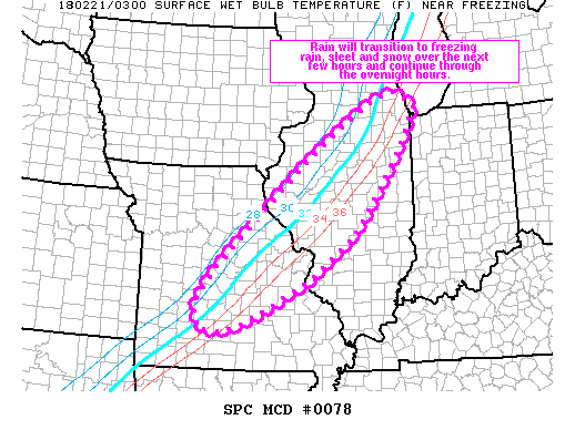
Areas affected...portions of northern and central IL into central MO
Concerning...Winter mixed precipitation
Valid 210318Z - 210915Z
SUMMARY...Rain will transition to a wintry mix of freezing rain,
sleet and snow across parts of northern and central IL into central
MO over the next several hours. This wintry mix is expected to
continue through the overnight hours, though precipitation rate
should remain light.
DISCUSSION...A slow, eastward-advancing cold front was draped from
roughly northwestern IN into northwest AR this evening. Cooler
temperatures are filtering southward across the mid-MS Valley, with
readings generally in the 32-37 degree F range from near Chicago
toward St. Louis and Springfield MO. Light to moderate precipitation
was occurring over this area with mainly rain noted on the eastern
edge of the MCD area with a mix of precip types further west. This
transition from rain to a wintry mix will slowly progress eastward
through 09z. Precipitation should generally remain light as heavier
precipitation translates eastward with the front. Freezing rain
rates up to 0.05 inches per 3 hours are expected through the night.
Sleet and occasionally light snow may mix with freezing rain.
..Leitman.. 02/21/2018
...Please see www.spc.noaa.gov for graphic product...
ATTN...WFO...LOT...ILX...LSX...DVN...SGF...
LAT...LON 41808743 40958789 40198839 39228910 38389018 37909104
37389207 37279259 37309306 37609318 37959312 38549267
39049218 40099101 40859017 41418940 41998851 42128797
42038771 41808743
|
|
Top/All Mesoscale Discussions/Forecast Products/Home
|
|


 @NWSSPC