|
| Mesoscale Discussion 79 |
|
< Previous MD Next MD >
|
|
Mesoscale Discussion 0079
NWS Storm Prediction Center Norman OK
0757 AM CST Wed Feb 21 2018
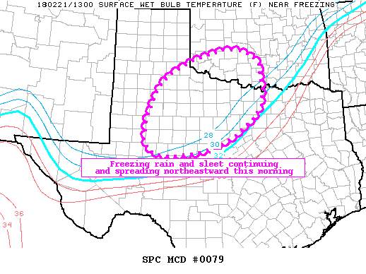
Areas affected...West-central/North Texas into southern Oklahoma
Concerning...Winter mixed precipitation
Valid 211357Z - 211800Z
SUMMARY...Winter mixed precipitation mainly in the form of sleet and
bouts of freezing rain will continue to expand generally
northeastward across the Texas Low Rolling Plains and Big Country
into southern Oklahoma through the morning.
DISCUSSION...Scattered showers and some thunderstorms have increased
early this morning especially across the Low Rolling Plains of
west-central into western North Texas. An increasing
northeastward-spreading zone of ascent atop the cold side of a
southeastward-advancing strong cold front will likely to support
some additional increase in northeastward-spreading precipitation
through the morning. A mix of sleet and freezing rain is likely
across the region as ample warm air aloft supports partial if not
full full meting atop an approximately 1 km deep near-ground cold
layer. Freezing rain should be most common as the predominant
precip-type especially in areas just behind the surface front
(roughly within 50-75 miles), with sleet more common in areas
farther north and/or associated with the thunderstorm-producing
convective elements.
..Guyer.. 02/21/2018
...Please see www.spc.noaa.gov for graphic product...
ATTN...WFO...FWD...OUN...SJT...LUB...MAF...
LAT...LON 34639727 33339723 32559797 31909923 31690106 32230173
33640134 34480053 35149856 34929754 34639727
|
|
Top/All Mesoscale Discussions/Forecast Products/Home
|
|


 @NWSSPC