|
| Mesoscale Discussion 1455 |
|
< Previous MD Next MD >
|
|
Mesoscale Discussion 1455
NWS Storm Prediction Center Norman OK
0159 AM CDT Sat Sep 15 2018
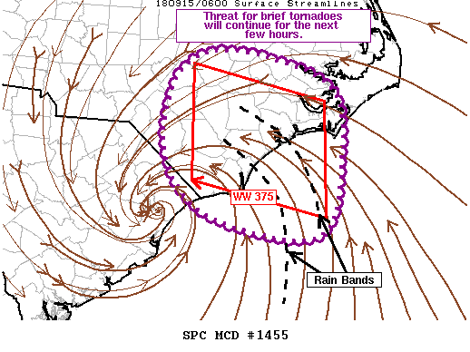
Areas affected...Eastern NC
Concerning...Tornado Watch 375...
Valid 150659Z - 150830Z
The severe weather threat for Tornado Watch 375 continues.
SUMMARY...Threat for a tornado or two will persist for the next few
hours as transient updraft strengthening occurs amidst favorable
low-level shear.
DISCUSSION...Recent radar imagery shows two well developed rain
bands extending through the northern and eastern periphery of
Tropical Storm Florence. Transient rotation has been noted in
several cells embedded within these bands, primarily while the cells
remained over the open water. Lightning has also been noted within
these bands and both the lightning and rotation indicate the
presence of somewhat more vigorous updrafts.
The general trend of occasional updraft strengthening and transient
rotation is expected to persist for the next several hours amidst
cell interactions and areas of locally enhanced surface convergence.
Instability is fairly limited with much of the better theta-e air
confined to the immediate coastal areas (delineated well by the 78
deg F isotherm). This relatively narrow zone of instability was
evidenced well by the line echo wave pattern noted within recent
KMHX radar imagery, which is quickly losing its definition as it
moves farther inland.
..Mosier.. 09/15/2018
...Please see www.spc.noaa.gov for graphic product...
ATTN...WFO...MHX...RAH...ILM...
LAT...LON 35357895 35707836 35597742 35217655 34427643 33377678
33647844 34407910 35357895
|
|
Top/All Mesoscale Discussions/Forecast Products/Home
|
|


 @NWSSPC