|
| Mesoscale Discussion 1456 |
|
< Previous MD Next MD >
|
|
Mesoscale Discussion 1456
NWS Storm Prediction Center Norman OK
0515 AM CDT Sat Sep 15 2018
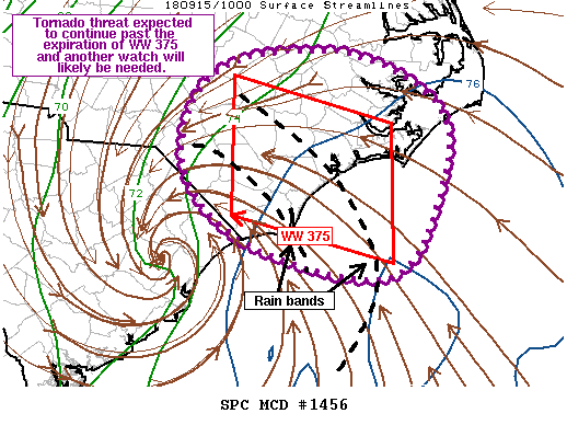
Areas affected...Eastern NC
Concerning...Tornado Watch 375...
Valid 151015Z - 151145Z
The severe weather threat for Tornado Watch 375 continues.
SUMMARY...Transient rotation has been noted within several cells
during the past few hours. Tornado potential will extend pass the
expiration of Tornado Watch 375 and another watch will likely be
needed.
DISCUSSION...Recent KRAX radar imagery depicted a near 30 kt
rotational velocity within a cell moving through Wayne County. Radar
data from KMHX has also sampled transient rotation within the rain
band extending offshore. The band has shown consistent development
of a line echo wave patterns as more intense portions of the band
approach the coast. Thermodynamic environment across much of the
region has remain relatively unchanged during the past several
hours, although there are now some indications (i.e. location of the
76 deg F isodrosotherm) that higher theta-e air has pushed a bit
further inland. Even so, the most unstable air remains over the
water and the immediate coastal areas.
Given the very slow motion of the system, the trends observed during
the past few hours are expected to persist into the morning. There
is some potential for greater instability to develop within any
cloud breaks after sunrise. However, the expansive cloud shield
associated with Florence suggests this possibility is uncertain.
Nevertheless, the potential for brief tornadoes is expected to
continue past the expiration time of Tornado Watch 375 and another
Tornado Watch will likely be needed.
..Mosier/Edwards.. 09/15/2018
...Please see www.spc.noaa.gov for graphic product...
ATTN...WFO...MHX...RAH...ILM...
LAT...LON 35407911 35767838 35757707 35237609 34507602 33477670
33807847 34577929 35407911
|
|
Top/All Mesoscale Discussions/Forecast Products/Home
|
|


 @NWSSPC