|
| Mesoscale Discussion 153 |
|
< Previous MD Next MD >
|
|
Mesoscale Discussion 0153
NWS Storm Prediction Center Norman OK
0441 PM CST Sun Mar 03 2019
Areas affected...Northern Maryland and Delaware northeastward into
southeast New York...and southern Connecticut
Concerning...Heavy snow
Valid 032241Z - 040245Z
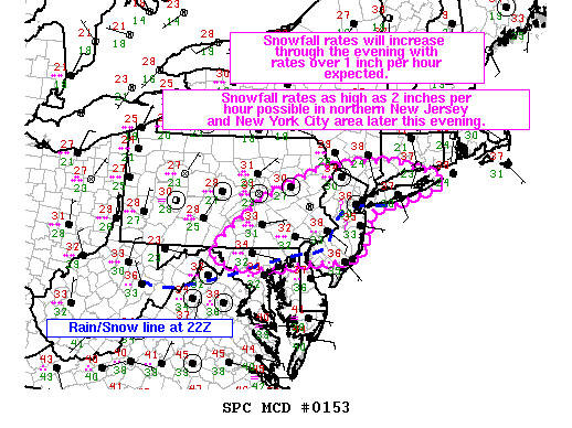
SUMMARY...Moderate snow is falling across much of northern Maryland
and Delaware, southeast Pennsylvania, and New Jersey at this time.
Snowfall rates are expected to increase through the evening with
snowfall rates in excess of 2 inches per hour in the New York City
metro area later this evening as the heaviest snow shifts
northeastward.
DISCUSSION...A 1005mb surface low is analyzed in northeast Georgia
at 22Z with an expanding precipitation field to its north. Light to
moderate snow is currently falling across northern Maryland and
Delaware, southeast Pennsylvania, and New Jersey. Precipitation
rates are expected to increase this evening as the surface low
continues to deepen and moves off the North Carolina coast by 04 to
05Z. The rain/snow line is expected to move slightly southeast over
the next hour as precipitation rates increase (especially over New
Jersey), but then move slightly northwest through the evening.
However, overall the rain/snow line is expected to stay within 25
miles of its current location. The heaviest snowfall is expected
just northwest of this rain/snow line later this evening. This will
most likely be near the New York City metro area between 03Z and 06Z
where snowfall rates could exceed 2 inches per hour in some
locations.
..Bentley.. 03/03/2019
...Please see www.spc.noaa.gov for graphic product...
ATTN...WFO...OKX...ALY...PHI...BGM...CTP...LWX...
LAT...LON 39767793 40677676 41327521 41457412 41447322 41347279
41217226 41057181 40917207 40757264 40587323 40567351
40487377 40297393 40017400 39807403 39467431 39457537
39327654 39357742 39457799 39767793
|
|
Top/All Mesoscale Discussions/Forecast Products/Home
|
|


 @NWSSPC