|
| Mesoscale Discussion 880 |
|
< Previous MD Next MD >
|
|
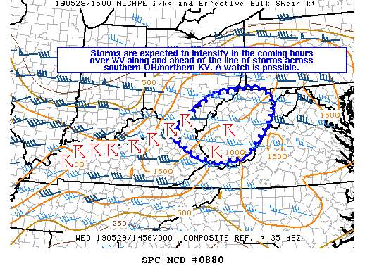
   Mesoscale Discussion 0880
   NWS Storm Prediction Center Norman OK
   1031 AM CDT Wed May 29 2019

   Areas affected...West Virginia...far southeast Ohio...far northeast
   Kentucky

   Concerning...Severe potential...Watch possible

   Valid 291531Z - 291730Z

   Probability of Watch Issuance...60 percent

   SUMMARY...Storms are expected to intensify in the coming hours along
   over West Virginia/vicinity ahead of the line storms across southern
   Ohio and northern Kentucky. Severe hail/wind are the main threats
   and a watch issuance is possible.

   DISCUSSION...Strong mid-level west/southwest flow (upwards of 50
   knots) is currently streaming over Ohio Valley into the Northeast
   per observations/mesoanalysis. A southwest-northeast QLCS has
   developed in the Ohio Valley and continues to move south/east. On
   the eastern edge, the orientation of the QLCS is more perpendicular
   to the west/southwest flow with a warm/moist/unstable airmass
   downstream. Additionally, discrete storms have started to develop in
   West Virginia as thermal/terrain circulations help break the cap
   within the warm sector. Updrafts have struggled to establish ahead
   of the QLCS, but it is likely discrete cells including some
   supercells will develop ahead of the QLCS in moderately
   sheared/buoyant environment (effective bulk shear 35-45
   knots/1000-2000 J/kg of MLCAPE).

   Severe hail/wind are the primary threats associated with the QLCS
   and discrete storms ahead of the line across much of West
   Virginia/vicinity. Storms will move eastward across the region
   during the afternoon and a watch issuance is possible.

   ..Nauslar/Thompson.. 05/29/2019

   ...Please see www.spc.noaa.gov for graphic product...

   ATTN...WFO...RNK...PBZ...RLX...JKL...ILN...

   LAT...LON   37908304 38228350 38608319 39178252 39598182 39738071
               39707988 39437951 39037948 38617970 38248001 37868037
               37628071 37528103 37458180 37638254 37908304
|
|
Top/All Mesoscale Discussions/Forecast Products/Home
|
|


 @NWSSPC