|
| Mesoscale Discussion 881 |
|
< Previous MD Next MD >
|
|
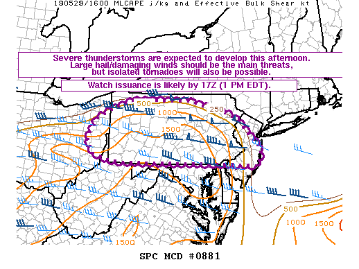
   Mesoscale Discussion 0881
   NWS Storm Prediction Center Norman OK
   1106 AM CDT Wed May 29 2019

   Areas affected...Portions of eastern OH...the northern WV
   Panhandle...much of PA...and NJ

   Concerning...Severe potential...Watch likely

   Valid 291606Z - 291730Z

   Probability of Watch Issuance...95 percent

   SUMMARY...Scattered severe thunderstorms are expected to develop
   this afternoon. Large hail and damaging winds should be the main
   threats, but isolated tornadoes will also be possible. Watch
   issuance is likely by 17Z (1 PM EDT).

   DISCUSSION...A shortwave trough over central OH and Lake Erie at 16Z
   will move eastward today across PA and vicinity. Isolated
   thunderstorms have recently initiated across central OH and
   northwestern PA in association with this feature. A belt of strong
   50-65 kt mid-level westerly winds will be present across eastern OH,
   much of PA, and NJ today. Long, nearly straight hodographs through
   mid levels and related 40-50 kt of effective bulk shear should favor
   scattered splitting supercells early this afternoon. Large hail will
   probably be the initial concern with this convection, with some
   increase in the damaging wind threat with time as storms potentially
   congeal into one or more bowing line segments as they move
   east-southeastward across PA into NJ. A marine front located over
   the NYC metro area and adjacent northern NJ will likely limit the
   northeastern extent of the substantial severe threat this afternoon.
   In addition to the large hail and damaging wind risk, isolated
   tornadoes could also occur over mainly parts of central/eastern PA
   into portions of NJ to the east of a weak surface low where
   low-level southwesterly winds are forecast to be somewhat stronger.
   Watch issuance will likely be needed across this region by 17Z (1 PM
   EDT).

   ..Gleason/Thompson.. 05/29/2019

   ...Please see www.spc.noaa.gov for graphic product...

   ATTN...WFO...PHI...BGM...CTP...PBZ...CLE...

   LAT...LON   39747986 39828061 39998122 40478142 41118105 41418044
               41737954 41767712 41407556 41157504 40607449 40367424
               40137406 39647419 39737575 39747986
|
|
Top/All Mesoscale Discussions/Forecast Products/Home
|
|


 @NWSSPC