|
| Mesoscale Discussion 1028 |
|
< Previous MD Next MD >
|
|
Mesoscale Discussion 1028
NWS Storm Prediction Center Norman OK
0444 PM CDT Sat Jun 08 2019
Areas affected...northeast Colorado
Concerning...Severe Thunderstorm Watch 344...
Valid 082144Z - 082245Z
The severe weather threat for Severe Thunderstorm Watch 344
continues.
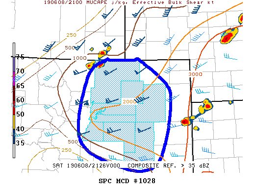
SUMMARY...Thunderstorms are developing within a moist-upslope
regime. The overall large-scale environment will support a threat
for severe thunderstorms, especially for any thunderstorm that can
move east off the terrain.
DISCUSSION...Thunderstorms developing within the moist-upslope
regime across north-central Colorado will continue for the next few
hours. The overall large-scale environment will maintain mixed-layer
CAPE around 1000-2000 J/kg and effective deep-layer shear around
60-knots. Initial updrafts appear to be tied to the underlying
terrain, which would limit the severe potential as updrafts and
downdrafts compete with one another. However, current indications
suggest some potential for at least a couple of thunderstorms to
move east off the terrain in the next couple of hours as suggested
by the thunderstorm in northwest Weld County. If this does occur,
the overall environment will support at least some severe threat for
any convective updraft that can sustain itself.
..Marsh/Grams.. 06/08/2019
...Please see www.spc.noaa.gov for graphic product...
ATTN...WFO...GLD...PUB...BOU...
LAT...LON 38510404 39120532 40590515 40990459 40990450 40990374
40990356 40430277 40030264 39140280 38520316 38510404
|
|
Top/All Mesoscale Discussions/Forecast Products/Home
|
|


 @NWSSPC