|
| Mesoscale Discussion 1189 |
|
< Previous MD Next MD >
|

|
   Mesoscale Discussion 1189
   NWS Storm Prediction Center Norman OK
   1133 PM CDT Fri Jun 21 2019

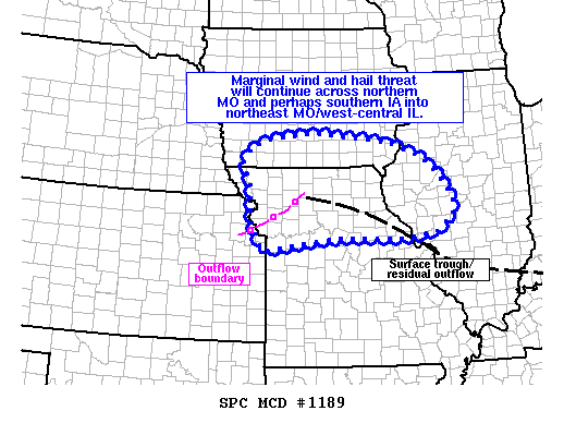
   Areas affected...northern MO...southern IA and west-central IL

   Concerning...Severe Thunderstorm Watch 421...

   Valid 220433Z - 220600Z

   The severe weather threat for Severe Thunderstorm Watch 421
   continues.

   SUMMARY...An isolated severe threat will persist across northern MO
   the next few hours. A more marginal threat may extend into southern
   IA and west-central IL through the overnight hours. Trends will be
   monitored for downstream watch potential.

   DISCUSSION...Elevated convection continues to develop late this
   evening across northern MO into southern IA and west-central IL.
   This convection is developing in part due to a 40-50 kt
   south/southwesterly low level jet overspreading the mid-MO/mid-MS
   Valley, which is aiding in isentropic ascent atop various outflow
   boundaries and weak confluence along a surface trough. MUCAPE ranges
   from around 2000-3500 J/kg across MO/IA to 500-1500 J/kg into
   west-central IL with most of this instability elevated above an EML
   between 850-700 mb. Steep midlevel lapse rates and marginal
   effective shear could be adequate for a few strong storms capable of
   near-severe hail and some gusty winds. Trends will be monitored for
   further organization, though the need for a downstream watch is
   uncertain at this time.

   ..Leitman.. 06/22/2019

   ...Please see www.spc.noaa.gov for graphic product...

   ATTN...WFO...ILX...LSX...DVN...DMX...EAX...OAX...

   LAT...LON   40709524 41029505 41179456 41319333 41109130 40779047
               40569014 39918958 39528962 39219005 39089085 39129187
               39129277 38859469 39409504 40199505 40709524
|
|
Top/All Mesoscale Discussions/Forecast Products/Home
|
|


