|
| Mesoscale Discussion 1984 |
|
< Previous MD Next MD >
|
|
Mesoscale Discussion 1984
NWS Storm Prediction Center Norman OK
0527 PM CST Fri Dec 10 2021
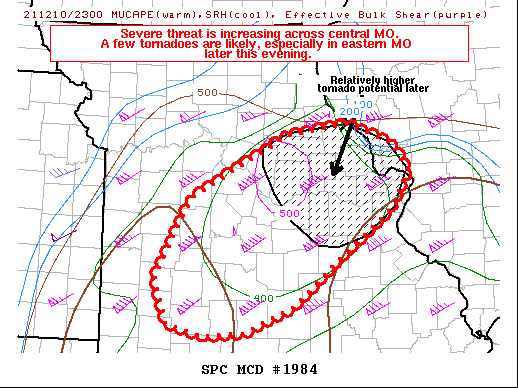
Areas affected...Portions of southwest into east-central Missouri
Concerning...Tornado Watch 553...
Valid 102327Z - 110230Z
The severe weather threat for Tornado Watch 553 continues.
SUMMARY...The severe threat appears to be gradually increasing
across portions of central Missouri. Large hail and damaging wind
gusts appear to be the primary threats, though a few tornadoes are
also likely, especially across eastern Missouri later this evening.
DISCUSSION...Deep-moist convection has recently initiated across
portions of southwest MO, just northwest of SGF within the past
hour. These storms are developing along the western fringes of a
moist warm sector, where near 60 F surface dewpoints are overspread
by 7 C/km mid-level lapse rates (evident via 22Z mesoanalysis and
previously noted by the 19Z SGF observed sounding). While the
surface winds are somewhat veered, the 21Z SGF VWP showed a modestly
curved but long hodograph depicting well over 300 m2/s2 SRH in both
the 0-1 km and 0-3 km layers.
As deep-layer ascent increases across the area and convective
inhibition continues to wane, additional storms are expected to
develop over the next several hours. A mixed mode of linear segments
and semi-discrete storms are expected, with all severe hazards
(including a couple of tornadoes) likely. The best chance for
tornadoes will be later this evening across eastern MO as the more
mature storms progress farther east into the LLJ axis, where
low-level shear is expected to be strongest and where MLCAPE may
exceed 1000 J/kg.
..Squitieri/Grams.. 12/10/2021
...Please see www.spc.noaa.gov for graphic product...
ATTN...WFO...LSX...SGF...EAX...
LAT...LON 37409190 37119260 37079314 37229368 37739385 38629335
39359194 39469106 39249044 38939021 38509047 38009114
37409190
|
|
Top/All Mesoscale Discussions/Forecast Products/Home
|
|


 @NWSSPC