|
| Mesoscale Discussion 32 |
|
< Previous MD Next MD >
|
|
Mesoscale Discussion 0032
NWS Storm Prediction Center Norman OK
0206 AM CST Wed Jan 04 2023
Areas affected...Alabama...Western Georgia...Western and Central
Florida Panhandle
Concerning...Tornado Watch 11...
Valid 040806Z - 041000Z
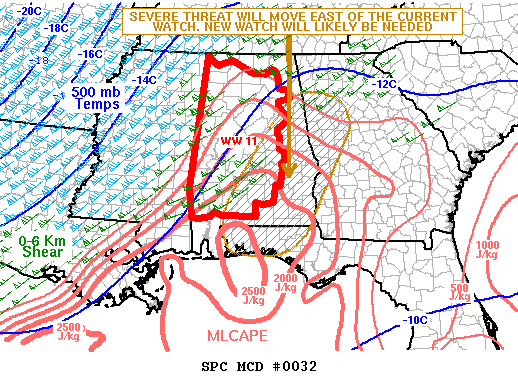
The severe weather threat for Tornado Watch 11 continues.
SUMMARY...A severe threat, with a potential for wind damage and
tornadoes, will develop to the east of WW 11 over the next couple of
hours. New weather watch issuance is expected by 10Z.
DISCUSSION...The latest mosaic radar imagery across the central Gulf
Coast region shows an organized convective line from southern
Mississippi extending northeastward into far northwest Georgia.
Along the leading edge, several short bowing line segments and
embedded supercells are ongoing. Moderate instability is analyzed by
the RAP ahead of the middle and southern sections of the line, where
MLCAPE generally ranges from 1200 to 2500 J/kg. In addition, WSR-88D
VWPs ahead of the line have 0-6 km shear near 60 knots with 0-3
storm relative helicities near 400 m2/s2. This environment will
continue to support supercells with tornado potential. Supercells,
along with short bowing line segments, will also have wind-damage
potential. The threat will continue to move eastward and may
eventually affect western Georgia early this morning.
..Broyles.. 01/04/2023
...Please see www.spc.noaa.gov for graphic product...
ATTN...WFO...FFC...TAE...BMX...MOB...
LAT...LON 31718734 31258754 30858754 30518741 30348700 30368600
30818532 31278507 32888423 33368407 33878431 34118497
34008566 33338627 32428692 31718734
|
|
Top/All Mesoscale Discussions/Forecast Products/Home
|
|


 @NWSSPC