|
| Mesoscale Discussion 31 |
|
< Previous MD Next MD >
|
|
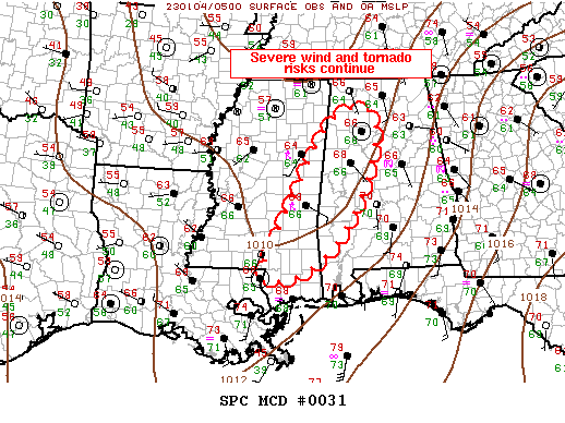
   Mesoscale Discussion 0031
   NWS Storm Prediction Center Norman OK
   1137 PM CST Tue Jan 03 2023

   Areas affected...Mississippi/Alabama

   Concerning...Tornado Watch 11...

   Valid 040537Z - 040700Z

   The severe weather threat for Tornado Watch 11 continues.

   SUMMARY...Severe wind/tornado risk will spread east across
   Mississippi into Alabama over the next several hours.

   DISCUSSION...Pre-frontal band of broken convection is gradually
   expanding in areal coverage late this evening. Numerous
   robust/severe thunderstorms extend along a corridor from southeast
   LA, through east-central MS, into northwest AL. Within this
   corridor, several long-lived supercells continue with one
   potentially tornadic storm over Clarke County MS, moving toward
   Choctaw County AL. This activity is maturing within a strongly
   sheared environment coincident with a 35kt LLJ. Instability has
   gradually recovered ahead of this convection with roughly 2000 J/kg
   MUCAPE now evident across the southern half of ww011. Damaging
   winds, along with some tornado risk, continue.

   ..Darrow.. 01/04/2023

   ...Please see www.spc.noaa.gov for graphic product...

   ATTN...WFO...BMX...HUN...MOB...MEG...JAN...LIX...

   LAT...LON   30818975 32528900 34158801 34168700 32428742 31108849
               30818975
|
|
Top/All Mesoscale Discussions/Forecast Products/Home
|
|


 @NWSSPC