|
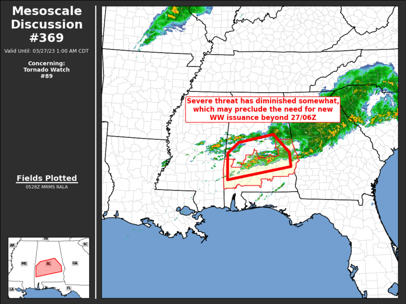
| Mesoscale Discussion 369 |
|
< Previous MD Next MD >
|
|
   Mesoscale Discussion 0369
   NWS Storm Prediction Center Norman OK
   1231 AM CDT Mon Mar 27 2023

   Areas affected...central and southern Alabama

   Concerning...Tornado Watch 89...

   Valid 270531Z - 270600Z

   The severe weather threat for Tornado Watch 89 continues.

   SUMMARY...Severe risk has decreased recently, and may remain
   sufficiently limited so as to not require new WW issuance beyond the
   currently scheduled 27/06Z expiration time of WW 89.

   DISCUSSION...Latest radar loop shows storms continuing across much
   of central and parts of southern Alabama.  More nearly surface-based
   storms are ongoing along the roughly west-to-east outflow/front,
   while farther north, more decidedly elevated storms continue to
   develop over east-central Mississippi, spreading repeatedly into
   west-central/central Alabama.

   Assessment of the current environment indicates ample CAPE
   (most-unstable values 1000 to 2000 J/kg across the WW area), and
   shear sufficient for organized updrafts with occasional mid-level
   rotation.  However, with low-level flow largely veered, tornado
   threat appears likely to remain limited/local over the next several
   hours.  While marginal severe risk will linger with
   stronger/longer-lived updrafts, overall risk appears sufficiently
   limited so as to not require new WW issuance.

   ..Goss.. 03/27/2023

   ...Please see www.spc.noaa.gov for graphic product...

   ATTN...WFO...BMX...MOB...

   LAT...LON   32548827 32978776 33308610 32588536 32018530 31488826
               32548827
|
|
Top/All Mesoscale Discussions/Forecast Products/Home
|
|


 @NWSSPC