 Note:
The expiration time in the watch graphic is amended if the watch is
replaced, cancelled or extended.
Note:
Note:
The expiration time in the watch graphic is amended if the watch is
replaced, cancelled or extended.
Note: Click for
Watch Status Reports.
SEL9
URGENT - IMMEDIATE BROADCAST REQUESTED
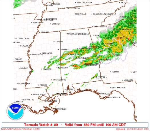
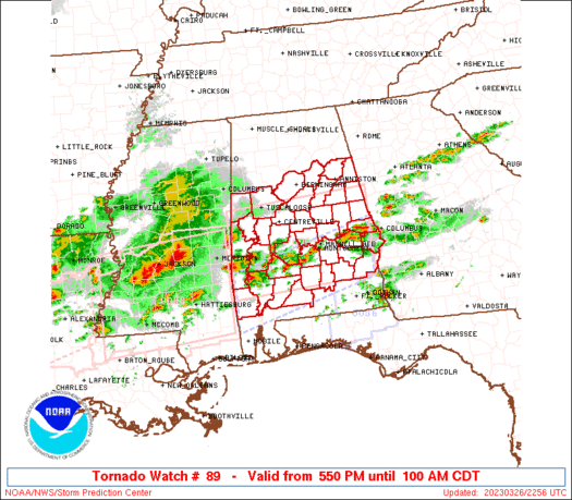
Tornado Watch Number 89
NWS Storm Prediction Center Norman OK
550 PM CDT Sun Mar 26 2023
The NWS Storm Prediction Center has issued a
* Tornado Watch for portions of
Central and southern Alabama
* Effective this Sunday afternoon and Monday morning from 550 PM
until 100 AM CDT.
* Primary threats include...
A few tornadoes likely with a couple intense tornadoes possible
Scattered large hail and isolated very large hail events to 3
inches in diameter likely
Scattered damaging wind gusts to 70 mph likely
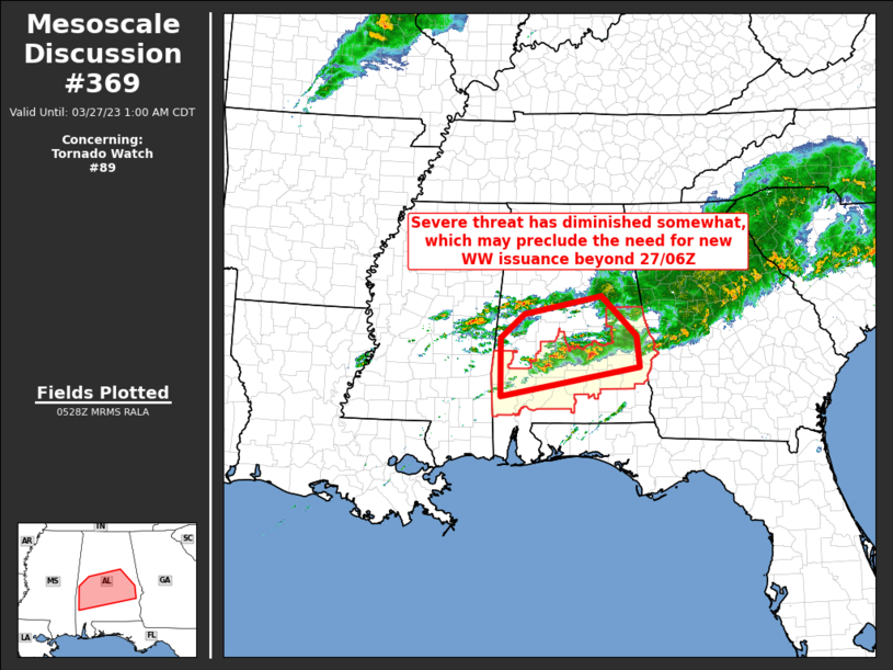
SUMMARY...Initial splitting supercells will persist this evening
across southern/central Alabama, with the threat for isolated very
large hail (2-3 inches in diameter). Later this evening, supercell
clusters will spread eastward from Mississippi into Alabama, when
the storm environment will become more favorable for tornadoes (a
couple of which could be strong). The threat for damaging winds to
70 mph and very large hail will persist into the early overnight
hours.
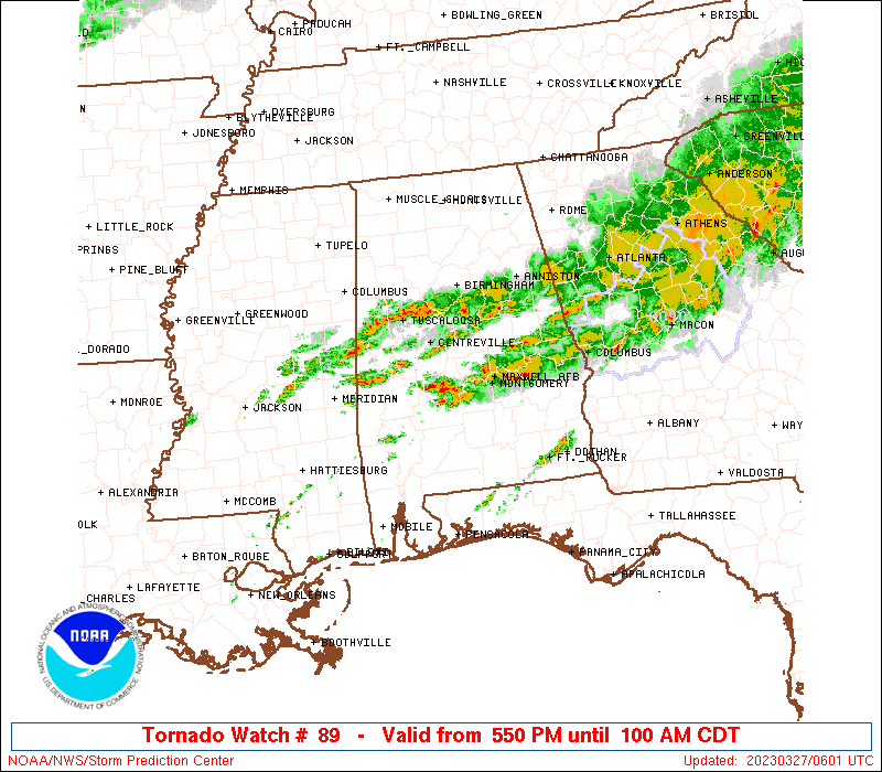
The tornado watch area is approximately along and 60 statute miles
north and south of a line from 85 miles west of Selma AL to 15 miles
east southeast of Auburn AL. For a complete depiction of the watch
see the associated watch outline update (WOUS64 KWNS WOU9).
PRECAUTIONARY/PREPAREDNESS ACTIONS...
REMEMBER...A Tornado Watch means conditions are favorable for
tornadoes and severe thunderstorms in and close to the watch
area. Persons in these areas should be on the lookout for
threatening weather conditions and listen for later statements
and possible warnings.
&&
OTHER WATCH INFORMATION...CONTINUE...WW 86...WW 87...WW 88...
AVIATION...Tornadoes and a few severe thunderstorms with hail
surface and aloft to 3 inches. Extreme turbulence and surface wind
gusts to 60 knots. A few cumulonimbi with maximum tops to 550. Mean
storm motion vector 25035.
...Thompson
   SEL9

   URGENT - IMMEDIATE BROADCAST REQUESTED
   Tornado Watch Number 89
   NWS Storm Prediction Center Norman OK
   550 PM CDT Sun Mar 26 2023

   The NWS Storm Prediction Center has issued a

   * Tornado Watch for portions of
     Central and southern Alabama

   * Effective this Sunday afternoon and Monday morning from 550 PM
     until 100 AM CDT.

   * Primary threats include...
     A few tornadoes likely with a couple intense tornadoes possible
     Scattered large hail and isolated very large hail events to 3
       inches in diameter likely
     Scattered damaging wind gusts to 70 mph likely

   SUMMARY...Initial splitting supercells will persist this evening
   across southern/central Alabama, with the threat for isolated very
   large hail (2-3 inches in diameter).  Later this evening, supercell
   clusters will spread eastward from Mississippi into Alabama, when
   the storm environment will become more favorable for tornadoes (a
   couple of which could be strong).  The threat for damaging winds to
   70 mph and very large hail will persist into the early overnight
   hours.

   The tornado watch area is approximately along and 60 statute miles
   north and south of a line from 85 miles west of Selma AL to 15 miles
   east southeast of Auburn AL. For a complete depiction of the watch
   see the associated watch outline update (WOUS64 KWNS WOU9).

   PRECAUTIONARY/PREPAREDNESS ACTIONS...

   REMEMBER...A Tornado Watch means conditions are favorable for
   tornadoes and severe thunderstorms in and close to the watch
   area. Persons in these areas should be on the lookout for
   threatening weather conditions and listen for later statements
   and possible warnings.

   &&

   OTHER WATCH INFORMATION...CONTINUE...WW 86...WW 87...WW 88...

   AVIATION...Tornadoes and a few severe thunderstorms with hail
   surface and aloft to 3 inches. Extreme turbulence and surface wind
   gusts to 60 knots. A few cumulonimbi with maximum tops to 550. Mean
   storm motion vector 25035.

   ...Thompson
 Note:
The Aviation Watch (SAW) product is an approximation to the watch area.
The actual watch is depicted by the shaded areas.
Note:
The Aviation Watch (SAW) product is an approximation to the watch area.
The actual watch is depicted by the shaded areas.
SAW9
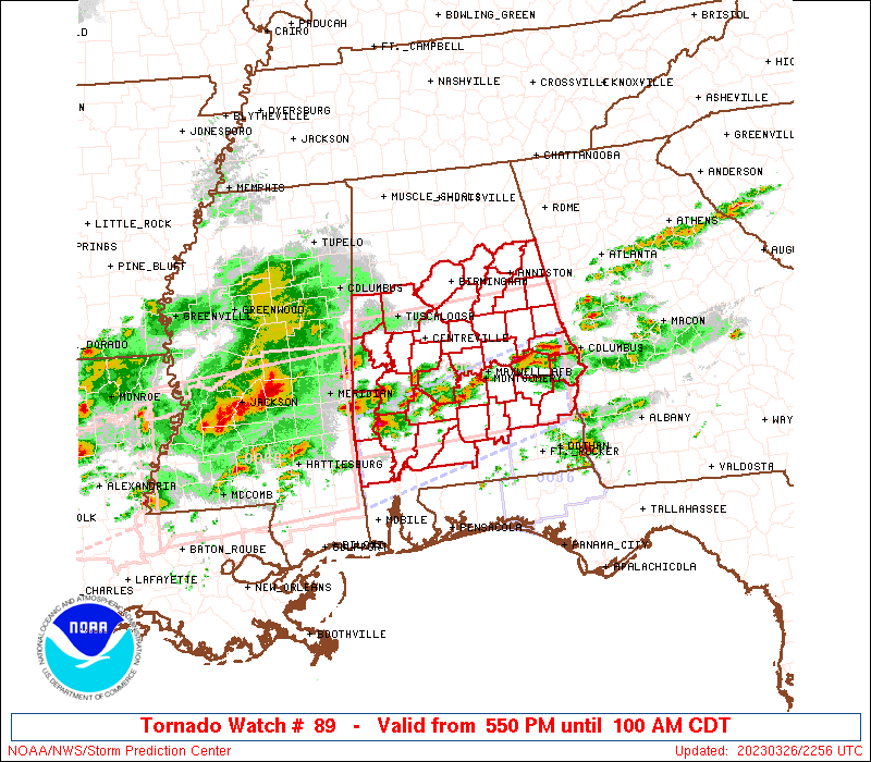
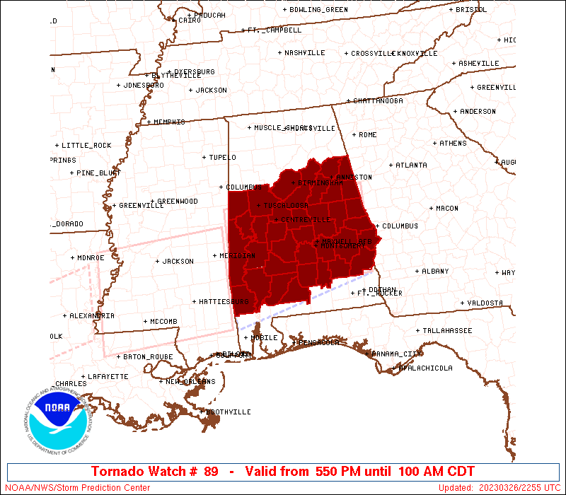
WW 89 TORNADO AL 262250Z - 270600Z
AXIS..60 STATUTE MILES NORTH AND SOUTH OF LINE..
85W SEM/SELMA AL/ - 15ESE AUO/AUBURN AL/
..AVIATION COORDS.. 50NM N/S /19E MEI - 31S LGC/
HAIL SURFACE AND ALOFT..3 INCHES. WIND GUSTS..60 KNOTS.
MAX TOPS TO 550. MEAN STORM MOTION VECTOR 25035.
LAT...LON 33218844 33408519 31668519 31478844
THIS IS AN APPROXIMATION TO THE WATCH AREA. FOR A
COMPLETE DEPICTION OF THE WATCH SEE WOUS64 KWNS
FOR WOU9.
Watch 89 Status Report Messages:
STATUS REPORT #5 ON WW 89

VALID 270430Z - 270540Z

SEVERE WEATHER THREAT CONTINUES RIGHT OF A LINE FROM 20 E MEI TO
15 W CSG.

..KERR..03/27/23

ATTN...WFO...BMX...MOB...

&&

STATUS REPORT FOR WT 89

SEVERE WEATHER THREAT CONTINUES FOR THE FOLLOWING AREAS

ALC005-011-013-023-025-041-047-081-085-087-099-101-109-113-131-
270540-

AL
.    ALABAMA COUNTIES INCLUDED ARE

BARBOUR 	     BULLOCK		 BUTLER
CHOCTAW 	     CLARKE		 CRENSHAW
DALLAS		     LEE		 LOWNDES
MACON		     MONROE		 MONTGOMERY
PIKE		     RUSSELL		 WILCOX
$$


THE WATCH STATUS MESSAGE IS FOR GUIDANCE PURPOSES ONLY.  PLEASE
REFER TO WATCH COUNTY NOTIFICATION STATEMENTS FOR OFFICIAL
INFORMATION ON COUNTIES...INDEPENDENT CITIES AND MARINE ZONES
CLEARED FROM SEVERE THUNDERSTORM AND TORNADO WATCHES.
$$

STATUS REPORT #4 ON WW 89

VALID 270330Z - 270440Z

SEVERE WEATHER THREAT CONTINUES RIGHT OF A LINE FROM 25 SE MEI TO
5 N MGM TO 45 WNW AUO TO 15 NW LGC.

..KERR..03/27/23

ATTN...WFO...BMX...MOB...

&&

STATUS REPORT FOR WT 89

SEVERE WEATHER THREAT CONTINUES FOR THE FOLLOWING AREAS

ALC005-011-013-017-023-025-041-047-081-085-087-099-101-109-113-
123-131-270440-

AL
.    ALABAMA COUNTIES INCLUDED ARE

BARBOUR 	     BULLOCK		 BUTLER
CHAMBERS	     CHOCTAW		 CLARKE
CRENSHAW	     DALLAS		 LEE
LOWNDES 	     MACON		 MONROE
MONTGOMERY	     PIKE		 RUSSELL
TALLAPOOSA	     WILCOX
$$


THE WATCH STATUS MESSAGE IS FOR GUIDANCE PURPOSES ONLY.  PLEASE
REFER TO WATCH COUNTY NOTIFICATION STATEMENTS FOR OFFICIAL
INFORMATION ON COUNTIES...INDEPENDENT CITIES AND MARINE ZONES
CLEARED FROM SEVERE THUNDERSTORM AND TORNADO WATCHES.
$$

STATUS REPORT #3 ON WW 89

VALID 270230Z - 270340Z

SEVERE WEATHER THREAT CONTINUES RIGHT OF A LINE FROM 20 E MEI TO
10 WNW SEM TO 35 N SEM TO 10 WSW LGC.

..KERR..03/27/23

ATTN...WFO...BMX...MOB...

&&

STATUS REPORT FOR WT 89

SEVERE WEATHER THREAT CONTINUES FOR THE FOLLOWING AREAS

ALC001-005-011-013-017-021-023-025-035-037-041-047-051-081-085-
087-091-099-101-109-113-123-129-131-270340-

AL
.    ALABAMA COUNTIES INCLUDED ARE

AUTAUGA 	     BARBOUR		 BULLOCK
BUTLER		     CHAMBERS		 CHILTON
CHOCTAW 	     CLARKE		 CONECUH
COOSA		     CRENSHAW		 DALLAS
ELMORE		     LEE		 LOWNDES
MACON		     MARENGO		 MONROE
MONTGOMERY	     PIKE		 RUSSELL
TALLAPOOSA	     WASHINGTON 	 WILCOX
$$


THE WATCH STATUS MESSAGE IS FOR GUIDANCE PURPOSES ONLY.  PLEASE
REFER TO WATCH COUNTY NOTIFICATION STATEMENTS FOR OFFICIAL
INFORMATION ON COUNTIES...INDEPENDENT CITIES AND MARINE ZONES
CLEARED FROM SEVERE THUNDERSTORM AND TORNADO WATCHES.
$$

STATUS REPORT #2 ON WW 89

VALID 270145Z - 270240Z

SEVERE WEATHER THREAT CONTINUES RIGHT OF A LINE FROM 35 NE MEI TO
15 SW TCL TO 30 NNW LGC.

..KERR..03/27/23

ATTN...WFO...BMX...MOB...

&&

STATUS REPORT FOR WT 89

SEVERE WEATHER THREAT CONTINUES FOR THE FOLLOWING AREAS

ALC001-005-007-011-013-017-021-023-025-027-029-035-037-041-047-
051-063-065-081-085-087-091-099-101-105-109-111-113-117-119-121-
123-129-131-270240-

AL
.    ALABAMA COUNTIES INCLUDED ARE

AUTAUGA 	     BARBOUR		 BIBB
BULLOCK 	     BUTLER		 CHAMBERS
CHILTON 	     CHOCTAW		 CLARKE
CLAY		     CLEBURNE		 CONECUH
COOSA		     CRENSHAW		 DALLAS
ELMORE		     GREENE		 HALE
LEE		     LOWNDES		 MACON
MARENGO 	     MONROE		 MONTGOMERY
PERRY		     PIKE		 RANDOLPH
RUSSELL 	     SHELBY		 SUMTER
TALLADEGA	     TALLAPOOSA 	 WASHINGTON
WILCOX
$$


THE WATCH STATUS MESSAGE IS FOR GUIDANCE PURPOSES ONLY.  PLEASE
REFER TO WATCH COUNTY NOTIFICATION STATEMENTS FOR OFFICIAL
INFORMATION ON COUNTIES...INDEPENDENT CITIES AND MARINE ZONES
CLEARED FROM SEVERE THUNDERSTORM AND TORNADO WATCHES.
$$

STATUS REPORT #1 ON WW 89

VALID 270035Z - 270140Z

THE SEVERE WEATHER THREAT CONTINUES ACROSS THE ENTIRE WATCH AREA.

FOR ADDITIONAL INFORMATION SEE MESOSCALE DISCUSSION 363

..THORNTON..03/27/23

ATTN...WFO...BMX...MOB...

&&

STATUS REPORT FOR WT 89

SEVERE WEATHER THREAT CONTINUES FOR THE FOLLOWING AREAS

ALC001-005-007-011-013-015-017-021-023-025-027-029-035-037-041-
047-051-063-065-073-081-085-087-091-099-101-105-107-109-111-113-
115-117-119-121-123-125-129-131-270140-

AL
.    ALABAMA COUNTIES INCLUDED ARE

AUTAUGA 	     BARBOUR		 BIBB
BULLOCK 	     BUTLER		 CALHOUN
CHAMBERS	     CHILTON		 CHOCTAW
CLARKE		     CLAY		 CLEBURNE
CONECUH 	     COOSA		 CRENSHAW
DALLAS		     ELMORE		 GREENE
HALE		     JEFFERSON		 LEE
LOWNDES 	     MACON		 MARENGO
MONROE		     MONTGOMERY 	 PERRY
PICKENS 	     PIKE		 RANDOLPH
RUSSELL 	     ST. CLAIR		 SHELBY
SUMTER		     TALLADEGA		 TALLAPOOSA
TUSCALOOSA	     WASHINGTON 	 WILCOX
$$


THE WATCH STATUS MESSAGE IS FOR GUIDANCE PURPOSES ONLY.  PLEASE
REFER TO WATCH COUNTY NOTIFICATION STATEMENTS FOR OFFICIAL
INFORMATION ON COUNTIES...INDEPENDENT CITIES AND MARINE ZONES
CLEARED FROM SEVERE THUNDERSTORM AND TORNADO WATCHES.
$$
Note:
Click for Complete Product Text.
Tornadoes
Probability of 2 or more tornadoes
|
High (70%)
|
Probability of 1 or more strong (EF2-EF5) tornadoes
|
Mod (50%)
|
Wind
Probability of 10 or more severe wind events
|
Mod (60%)
|
Probability of 1 or more wind events > 65 knots
|
Low (20%)
|
Hail
Probability of 10 or more severe hail events
|
Mod (60%)
|
Probability of 1 or more hailstones > 2 inches
|
Mod (60%)
|
Combined Severe Hail/Wind
Probability of 6 or more combined severe hail/wind events
|
High (>95%)
|
For each watch, probabilities for particular events inside the watch
(listed above in each table) are determined by the issuing forecaster.
The "Low" category contains probability values ranging from less than 2%
to 20% (EF2-EF5 tornadoes), less than 5% to 20% (all other probabilities),
"Moderate" from 30% to 60%, and "High" from 70% to greater than 95%.
High values are bolded and lighter in color to provide awareness of
an increased threat for a particular event.


 @NWSSPC