|
| Mesoscale Discussion 1099 |
|
< Previous MD Next MD >
|
|
Mesoscale Discussion 1099
NWS Storm Prediction Center Norman OK
0641 AM CDT Fri Jun 16 2023
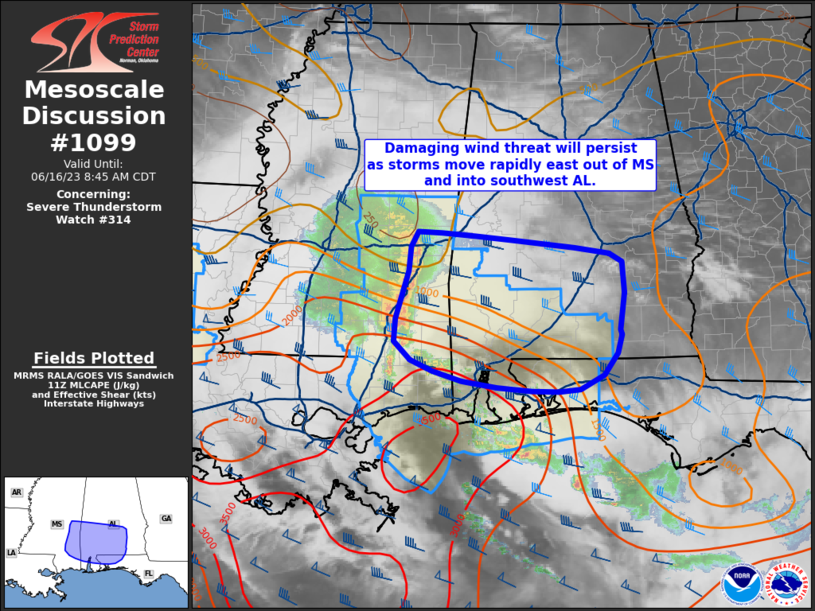
Areas affected...central and southern Mississippi into southern
Alabama and the western Florida Panhandle
Concerning...Severe Thunderstorm Watch 314...
Valid 161141Z - 161345Z
The severe weather threat for Severe Thunderstorm Watch 314
continues.
SUMMARY...The threat for damaging winds is greatest currently over
east-central Mississippi, and will extend into southwest Alabama
shortly. Small areas in Alabama just north of the watch may have a
damaging-wind threat as well.
DISCUSSION...A steady-state MCS continues to move rapidly east
across central and into east-central MS, at a speed around 55 kt.
This MCS is currently riding along the instability gradient which is
oriented from northwest to southeast from southern MS into the FL
Panhandle. Given this orientation, it is possible that northern
portions of the MCS may weaken over time, with the stronger storm
cores translating southeastward into the warmer air mass. While
parts of southern AL and the FL Panhandle are cooler at the surface
due to outflow from the overnight storms/flooding, veered/westerly
winds above this relative cool layer should aid elevated
instability, which may continue to fuel the MCS with damaging-wind
potential.
..Jewell.. 06/16/2023
...Please see www.spc.noaa.gov for graphic product...
ATTN...WFO...TAE...BMX...MOB...JAN...
LAT...LON 32508889 32318670 32248623 32158605 31778602 31348607
31278605 31058611 30808630 30638664 30608731 30728829
30978899 31198923 31478921 32048903 32328899 32508889
|
|
Top/All Mesoscale Discussions/Forecast Products/Home
|
|


 @NWSSPC