 Note:
The expiration time in the watch graphic is amended if the watch is
replaced, cancelled or extended.
Note:
Note:
The expiration time in the watch graphic is amended if the watch is
replaced, cancelled or extended.
Note: Click for
Watch Status Reports.
SEL4
URGENT - IMMEDIATE BROADCAST REQUESTED
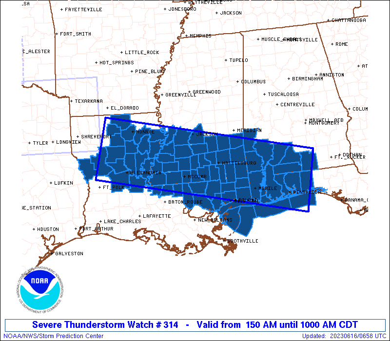
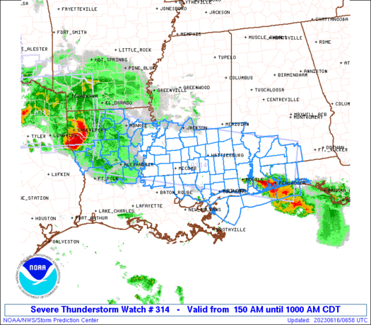
Severe Thunderstorm Watch Number 314
NWS Storm Prediction Center Norman OK
150 AM CDT Fri Jun 16 2023
The NWS Storm Prediction Center has issued a
* Severe Thunderstorm Watch for portions of
Southern Alabama
Western Florida Panhandle
Northern to eastern Louisiana
Southern to parts of central Mississippi
Coastal Waters
* Effective this Friday morning from 150 AM until 1000 AM CDT.
* Primary threats include...
Scattered damaging winds likely with isolated significant gusts
to 80 mph possible
Isolated very large hail events to 2 inches in diameter possible
A tornado or two possible
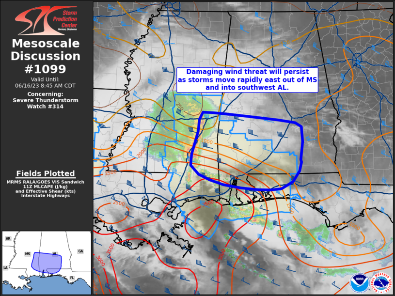
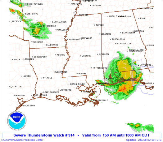
SUMMARY...A bowing MCS will sweep east-southeastward near a
slow-moving frontal zone through much of the remainder of the
morning, offering severe winds with isolated gusts of 75+ mph and
derecho extent possible. A tornado or two may spin up in embedded
QLCS mesovortices, and isolated large hail also is possible.
The severe thunderstorm watch area is approximately along and 60
statute miles either side of a line from 25 miles north of
Natchitoches LA to 5 miles southeast of Crestview FL. For a complete
depiction of the watch see the associated watch outline update
(WOUS64 KWNS WOU4).
PRECAUTIONARY/PREPAREDNESS ACTIONS...
REMEMBER...A Severe Thunderstorm Watch means conditions are
favorable for severe thunderstorms in and close to the watch area.
Persons in these areas should be on the lookout for threatening
weather conditions and listen for later statements and possible
warnings. Severe thunderstorms can and occasionally do produce
tornadoes.
&&
OTHER WATCH INFORMATION...CONTINUE...WW 312...WW 313...
AVIATION...A few severe thunderstorms with hail surface and aloft to
2 inches. Extreme turbulence and surface wind gusts to 70 knots. A
few cumulonimbi with maximum tops to 600. Mean storm motion vector
29045.
...Edwards
   SEL4

   URGENT - IMMEDIATE BROADCAST REQUESTED
   Severe Thunderstorm Watch Number 314
   NWS Storm Prediction Center Norman OK
   150 AM CDT Fri Jun 16 2023

   The NWS Storm Prediction Center has issued a

   * Severe Thunderstorm Watch for portions of
     Southern Alabama
     Western Florida Panhandle
     Northern to eastern Louisiana
     Southern to parts of central Mississippi
     Coastal Waters

   * Effective this Friday morning from 150 AM until 1000 AM CDT.

   * Primary threats include...
     Scattered damaging winds likely with isolated significant gusts
       to 80 mph possible
     Isolated very large hail events to 2 inches in diameter possible
     A tornado or two possible

   SUMMARY...A bowing MCS will sweep east-southeastward near a
   slow-moving frontal zone through much of the remainder of the
   morning, offering severe winds with isolated gusts of 75+ mph and
   derecho extent possible.  A tornado or two may spin up in embedded
   QLCS mesovortices, and isolated large hail also is possible.

   The severe thunderstorm watch area is approximately along and 60
   statute miles either side of a line from 25 miles north of
   Natchitoches LA to 5 miles southeast of Crestview FL. For a complete
   depiction of the watch see the associated watch outline update
   (WOUS64 KWNS WOU4).

   PRECAUTIONARY/PREPAREDNESS ACTIONS...

   REMEMBER...A Severe Thunderstorm Watch means conditions are
   favorable for severe thunderstorms in and close to the watch area.
   Persons in these areas should be on the lookout for threatening
   weather conditions and listen for later statements and possible
   warnings. Severe thunderstorms can and occasionally do produce
   tornadoes.

   &&

   OTHER WATCH INFORMATION...CONTINUE...WW 312...WW 313...

   AVIATION...A few severe thunderstorms with hail surface and aloft to
   2 inches. Extreme turbulence and surface wind gusts to 70 knots. A
   few cumulonimbi with maximum tops to 600. Mean storm motion vector
   29045.

   ...Edwards
 Note:
The Aviation Watch (SAW) product is an approximation to the watch area.
The actual watch is depicted by the shaded areas.
Note:
The Aviation Watch (SAW) product is an approximation to the watch area.
The actual watch is depicted by the shaded areas.
   SAW4
   WW 314 SEVERE TSTM AL FL LA MS CW 160650Z - 161500Z
   AXIS..60 STATUTE MILES EITHER SIDE OF LINE..
   25N IER/NATCHITOCHES LA/ - 5SE CEW/CRESTVIEW FL/
   ..AVIATION COORDS.. 50NM EITHER SIDE /54SE EIC - 13ESE CEW/
   HAIL SURFACE AND ALOFT..2 INCHES. WIND GUSTS..70 KNOTS.
   MAX TOPS TO 600. MEAN STORM MOTION VECTOR 29045.

   LAT...LON 32959289 31588626 29888666 31259330

   THIS IS AN APPROXIMATION TO THE WATCH AREA.  FOR A
   COMPLETE DEPICTION OF THE WATCH SEE WOUS64 KWNS
   FOR WOU4.
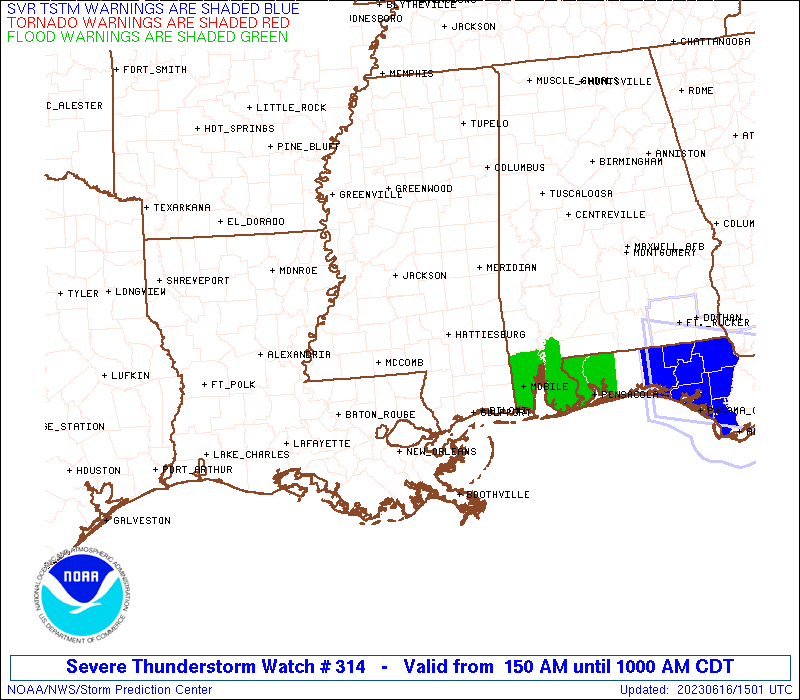
Watch 314 Status Report Messages:
STATUS REPORT #3 ON WW 314

VALID 161255Z - 161340Z

SEVERE WEATHER THREAT CONTINUES RIGHT OF A LINE FROM 55 WSW MCB
TO 30 NNW ASD TO 35 N GPT TO 40 NNW MOB TO 55 SE MEI TO 55 WSW
SEM TO 40 W SEM.

..JEWELL..06/16/23

ATTN...WFO...MOB...LCH...SHV...JAN...LIX...

&&

STATUS REPORT FOR WS 314

SEVERE WEATHER THREAT CONTINUES FOR THE FOLLOWING AREAS

ALC003-025-035-039-053-097-099-129-161340-

AL
.    ALABAMA COUNTIES INCLUDED ARE

BALDWIN 	     CLARKE		 CONECUH
COVINGTON	     ESCAMBIA		 MOBILE
MONROE		     WASHINGTON
$$


FLC033-091-113-161340-

FL
.    FLORIDA COUNTIES INCLUDED ARE

ESCAMBIA	     OKALOOSA		 SANTA ROSA
$$


MSC039-047-059-131-161340-

MS
.    MISSISSIPPI COUNTIES INCLUDED ARE

GEORGE		     HARRISON		 JACKSON
STONE
$$


GMZ532-536-557-630-631-632-633-634-635-636-650-655-161340-

CW

.    ADJACENT COASTAL WATERS INCLUDED ARE

MISSISSIPPI SOUND

CHANDELEUR SOUND

COASTAL WATERS FROM PASCAGOULA MISSISSIPPI TO STAKE ISLAND OUT 20
NM

NORTH MOBILE BAY

SOUTH MOBILE BAY

MISSISSIPPI SOUND

PERDIDO BAY AREA

PENSACOLA BAY AREA INCLUDING SANTA ROSA SOUND

WESTERN CHOCTAWHATCHEE BAY

EASTERN CHOCTAWHATCHEE BAY

COASTAL WATERS FROM PENSACOLA FL TO PASCAGOULA MS OUT 20 NM

COASTAL WATERS FROM OKALOOSA-WALTON COUNTY LINE TO PENSACOLA FL
OUT 20 NM

$$
THE WATCH STATUS MESSAGE IS FOR GUIDANCE PURPOSES ONLY.  PLEASE
REFER TO WATCH COUNTY NOTIFICATION STATEMENTS FOR OFFICIAL
INFORMATION ON COUNTIES...INDEPENDENT CITIES AND MARINE ZONES
CLEARED FROM SEVERE THUNDERSTORM AND TORNADO WATCHES.
$$

STATUS REPORT #2 ON WW 314

VALID 161100Z - 161240Z

SEVERE WEATHER THREAT CONTINUES RIGHT OF A LINE FROM 50 W IER TO
20 SW IER TO 25 SE IER TO 5 ENE ESF TO 20 SSW HEZ TO 15 NNE MCB
TO 40 NNE MCB TO 70 NW PIB TO 65 S GWO TO 30 SW GWO.

..JEWELL..06/16/23

ATTN...WFO...MOB...LCH...SHV...JAN...LIX...

&&

STATUS REPORT FOR WS 314

SEVERE WEATHER THREAT CONTINUES FOR THE FOLLOWING AREAS

ALC003-023-025-035-039-053-097-099-129-161240-

AL
.    ALABAMA COUNTIES INCLUDED ARE

BALDWIN 	     CHOCTAW		 CLARKE
CONECUH 	     COVINGTON		 ESCAMBIA
MOBILE		     MONROE		 WASHINGTON
$$


FLC033-091-113-161240-

FL
.    FLORIDA COUNTIES INCLUDED ARE

ESCAMBIA	     OKALOOSA		 SANTA ROSA
$$


LAC009-037-079-091-103-105-117-125-161240-

LA
.    LOUISIANA PARISHES INCLUDED ARE

AVOYELLES	     EAST FELICIANA	 RAPIDES
ST. HELENA	     ST. TAMMANY	 TANGIPAHOA
WASHINGTON	     WEST FELICIANA
$$


MSC005-023-029-031-035-039-041-045-047-059-061-065-067-069-073-
075-077-079-085-089-091-099-101-109-111-113-121-123-127-129-131-
147-153-157-163-161240-

MS
.    MISSISSIPPI COUNTIES INCLUDED ARE

AMITE		     CLARKE		 COPIAH
COVINGTON	     FORREST		 GEORGE
GREENE		     HANCOCK		 HARRISON
JACKSON 	     JASPER		 JEFFERSON DAVIS
JONES		     KEMPER		 LAMAR
LAUDERDALE	     LAWRENCE		 LEAKE
LINCOLN 	     MADISON		 MARION
NESHOBA 	     NEWTON		 PEARL RIVER
PERRY		     PIKE		 RANKIN
SCOTT		     SIMPSON		 SMITH
STONE		     WALTHALL		 WAYNE
WILKINSON	     YAZOO
$$


GMZ532-536-557-630-631-632-633-634-635-636-650-655-161240-

CW

.    ADJACENT COASTAL WATERS INCLUDED ARE

MISSISSIPPI SOUND

CHANDELEUR SOUND

COASTAL WATERS FROM PASCAGOULA MISSISSIPPI TO STAKE ISLAND OUT 20
NM

NORTH MOBILE BAY

SOUTH MOBILE BAY

MISSISSIPPI SOUND

PERDIDO BAY AREA

PENSACOLA BAY AREA INCLUDING SANTA ROSA SOUND

WESTERN CHOCTAWHATCHEE BAY

EASTERN CHOCTAWHATCHEE BAY

COASTAL WATERS FROM PENSACOLA FL TO PASCAGOULA MS OUT 20 NM

COASTAL WATERS FROM OKALOOSA-WALTON COUNTY LINE TO PENSACOLA FL
OUT 20 NM

$$
THE WATCH STATUS MESSAGE IS FOR GUIDANCE PURPOSES ONLY.  PLEASE
REFER TO WATCH COUNTY NOTIFICATION STATEMENTS FOR OFFICIAL
INFORMATION ON COUNTIES...INDEPENDENT CITIES AND MARINE ZONES
CLEARED FROM SEVERE THUNDERSTORM AND TORNADO WATCHES.
$$

STATUS REPORT #1 ON WW 314

VALID 161100Z - 161240Z

SEVERE WEATHER THREAT CONTINUES RIGHT OF A LINE FROM 50 W IER TO
20 SW IER TO 25 SE IER TO 5 ENE ESF TO 20 SSW HEZ TO 15 NNE MCB
TO 40 NNE MCB TO 70 NW PIB TO 65 S GWO TO 30 SW GWO.

..JEWELL..06/16/23

ATTN...WFO...MOB...LCH...SHV...JAN...LIX...

&&

STATUS REPORT FOR WS 314

SEVERE WEATHER THREAT CONTINUES FOR THE FOLLOWING AREAS

ALC003-023-025-035-039-053-097-099-129-161240-

AL
.    ALABAMA COUNTIES INCLUDED ARE

BALDWIN 	     CHOCTAW		 CLARKE
CONECUH 	     COVINGTON		 ESCAMBIA
MOBILE		     MONROE		 WASHINGTON
$$


FLC033-091-113-161240-

FL
.    FLORIDA COUNTIES INCLUDED ARE

ESCAMBIA	     OKALOOSA		 SANTA ROSA
$$


LAC009-037-079-091-103-105-117-125-161240-

LA
.    LOUISIANA PARISHES INCLUDED ARE

AVOYELLES	     EAST FELICIANA	 RAPIDES
ST. HELENA	     ST. TAMMANY	 TANGIPAHOA
WASHINGTON	     WEST FELICIANA
$$


MSC005-023-029-031-035-039-041-045-047-059-061-065-067-069-073-
075-077-079-085-089-091-099-101-109-111-113-121-123-127-129-131-
147-153-157-163-161240-

MS
.    MISSISSIPPI COUNTIES INCLUDED ARE

AMITE		     CLARKE		 COPIAH
COVINGTON	     FORREST		 GEORGE
GREENE		     HANCOCK		 HARRISON
JACKSON 	     JASPER		 JEFFERSON DAVIS
JONES		     KEMPER		 LAMAR
LAUDERDALE	     LAWRENCE		 LEAKE
LINCOLN 	     MADISON		 MARION
NESHOBA 	     NEWTON		 PEARL RIVER
PERRY		     PIKE		 RANKIN
SCOTT		     SIMPSON		 SMITH
STONE		     WALTHALL		 WAYNE
WILKINSON	     YAZOO
$$


GMZ532-536-557-630-631-632-633-634-635-636-650-655-161240-

CW

.    ADJACENT COASTAL WATERS INCLUDED ARE

MISSISSIPPI SOUND

CHANDELEUR SOUND

COASTAL WATERS FROM PASCAGOULA MISSISSIPPI TO STAKE ISLAND OUT 20
NM

NORTH MOBILE BAY

SOUTH MOBILE BAY

MISSISSIPPI SOUND

PERDIDO BAY AREA

PENSACOLA BAY AREA INCLUDING SANTA ROSA SOUND

WESTERN CHOCTAWHATCHEE BAY

EASTERN CHOCTAWHATCHEE BAY

COASTAL WATERS FROM PENSACOLA FL TO PASCAGOULA MS OUT 20 NM

COASTAL WATERS FROM OKALOOSA-WALTON COUNTY LINE TO PENSACOLA FL
OUT 20 NM

$$
THE WATCH STATUS MESSAGE IS FOR GUIDANCE PURPOSES ONLY.  PLEASE
REFER TO WATCH COUNTY NOTIFICATION STATEMENTS FOR OFFICIAL
INFORMATION ON COUNTIES...INDEPENDENT CITIES AND MARINE ZONES
CLEARED FROM SEVERE THUNDERSTORM AND TORNADO WATCHES.
$$
Note:
Click for Complete Product Text.
Tornadoes
Probability of 2 or more tornadoes
|
Low (20%)
|
Probability of 1 or more strong (EF2-EF5) tornadoes
|
Low (10%)
|
Wind
Probability of 10 or more severe wind events
|
High (70%)
|
Probability of 1 or more wind events > 65 knots
|
Mod (30%)
|
Hail
Probability of 10 or more severe hail events
|
Mod (30%)
|
Probability of 1 or more hailstones > 2 inches
|
Mod (30%)
|
Combined Severe Hail/Wind
Probability of 6 or more combined severe hail/wind events
|
High (>95%)
|
For each watch, probabilities for particular events inside the watch
(listed above in each table) are determined by the issuing forecaster.
The "Low" category contains probability values ranging from less than 2%
to 20% (EF2-EF5 tornadoes), less than 5% to 20% (all other probabilities),
"Moderate" from 30% to 60%, and "High" from 70% to greater than 95%.
High values are bolded and lighter in color to provide awareness of
an increased threat for a particular event.


 @NWSSPC