|
| Mesoscale Discussion 395 |
|
< Previous MD Next MD >
|
|
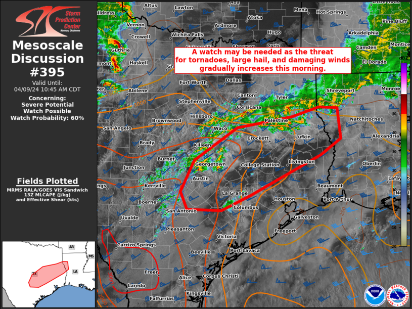
   Mesoscale Discussion 0395
   NWS Storm Prediction Center Norman OK
   0848 AM CDT Tue Apr 09 2024

   Areas affected...Portions of central/east TX into northwestern LA

   Concerning...Severe potential...Watch possible

   Valid 091348Z - 091545Z

   Probability of Watch Issuance...60 percent

   SUMMARY...A watch may be needed as the threat for tornadoes, large
   hail, and damaging winds gradually increases this morning.

   DISCUSSION...Warm advection associated with a 35-45 kt southerly
   low-level jet, along with ascent attendant to the left exit region
   of a southwesterly mid/upper-level jet, is aiding convection across
   parts of central/east TX into northwestern LA. Some of this activity
   across central TX is occurring near a convectively reinforced
   outflow boundary, with a rich low-level airmass present along/south
   of this boundary. Steep mid-level lapse rates are supporting
   1500-2000 J/kg of MLCAPE in central TX, even though daytime heating
   remains muted thus far, with lesser instability into east TX and
   northwestern LA. Still, strong deep-layer shear of 50+ kt will
   foster updraft organization and supercell potential. Large to very
   large hail will be a concern with these supercells as they spread
   east-northeastward this morning. An increasing potential for
   severe/damaging winds may be realized if a cluster forms along the
   outflow boundary/front. Sufficient low-level shear is also present
   for low-level updraft rotation and some tornado threat. Watch
   issuance may be needed if convection continues to increase in
   coverage and intensity across central TX.

   ..Gleason/Thompson.. 04/09/2024

   ...Please see www.spc.noaa.gov for graphic product...

   ATTN...WFO...LCH...SHV...HGX...FWD...EWX...

   LAT...LON   30029806 30829766 31659640 31939477 32179397 32159343
               31369333 30959394 29939603 29559685 29579786 30029806
|
|
Top/All Mesoscale Discussions/Forecast Products/Home
|
|


 @NWSSPC