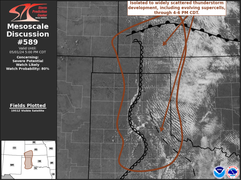
   Mesoscale Discussion 0589
   NWS Storm Prediction Center Norman OK
   0257 PM CDT Wed May 01 2024

   Areas affected...parts of northwest Texas and the Texas Panhandle
   into southwestern Kansas

   Concerning...Severe potential...Watch likely

   Valid 011957Z - 012200Z

   Probability of Watch Issuance...80 percent

   SUMMARY...Isolated to widely scattered thunderstorm development
   appears increasingly likely through 4-6 PM CDT, including the
   evolution of supercells with potential to produce large hail in
   excess of 2 inches in diameter, and a risk for tornadoes.

   DISCUSSION...Deepening convective development is evident
   south-southeast through northeast of Amarillo, along a sharpening
   dryline that extends northward into southwestern Kansas near Garden
   City.  To the east of this boundary, the western flank of a
   boundary-layer air mass impacted by convective outflow appears to be
   gradually modifying  across the eastern Texas Panhandle into the
   Childress vicinity, in response to continuing isolation.

   Aside from weak lower/mid-tropospheric warm advection, large-scale
   forcing for ascent may remain weak to negligible into early evening,
   and the warming aloft will contribute to increasing inhibition to
   the east of the dryline.  However, with further surface heating, it
   appears that the approach of convective temperatures along the
   dryline and differential heating boundary will contribute to
   increasing probabilities for isolated to widely scattered
   thunderstorm development through 21-23Z.

   With 60s to near 70F surface dew points contributing to large
   mixed-layer CAPE on the order of 2000-3000 J/kg along the surface
   boundaries, in the presence of steep lapse rates,  the environment
   is becoming increasingly support of potential for supercells beneath
   30-40 kt west-southwesterly flow around 500 mb.  Models suggest that
   this may veer to more of a westerly component by early evening,
   while modest southerly flow around 850 mb backs with time and
   strengthens to around 30+ kt across the eastern Texas Panhandle.  As
   this occurs, profiles appear likely to become increasingly
   supportive of strengthening low-level mesocyclones with potential to
   produce tornadoes.

   Tornadic potential may become maximized with stronger cells tending
   to propagate eastward and southeastward across the differential
   heating boundary, before they tend to weaken as they encounter more
   stable updraft inflow.  However, in the wake of this activity,
   renewed vigorous thunderstorm development is likely to persist along
   the stationary to slowly retreating dryline into early evening, with
   a continuing risk for large hail and tornadoes.

   ..Kerr/Hart.. 05/01/2024

   ...Please see www.spc.noaa.gov for graphic product...

   ATTN...WFO...OUN...DDC...LUB...AMA...PUB...

   LAT...LON   34920202 36060177 37020206 37600219 38140090 38339969
               37339938 36359964 35579977 34949963 34299960 33650005
               33440120 33690192 34350178 34920202
|


 @NWSSPC