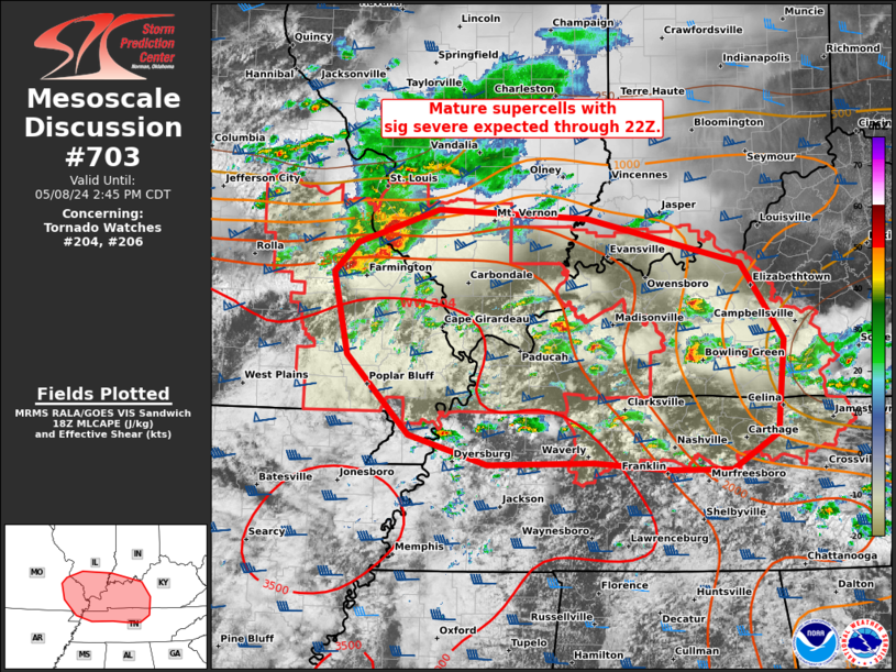
   Mesoscale Discussion 0703
   NWS Storm Prediction Center Norman OK
   0150 PM CDT Wed May 08 2024

   Areas affected...parts of the Mid-MS...Lower OH...and TN Valleys

   Concerning...Tornado Watch 204...206...

   Valid 081850Z - 081945Z

   The severe weather threat for Tornado Watch 204, 206 continues.

   SUMMARY...Very large hail, isolated severe wind gusts, and tornadoes
   will remain probable with mature supercells across parts of the
   Mid-Mississippi to Lower Ohio and Tennessee Valleys through the rest
   of the afternoon.

   DISCUSSION...Several supercells are ongoing with two distinct
   regimes. An intense, long-track supercell in cluster regime persists
   across a part of the Mid-MS Valley, between STL and CGI. Numerous
   large hail up to baseball size have been reported during the past
   hour. This supercell cluster should continue to evolve east along
   the tight instability gradient across southern IL, with potential
   for further upscale growth along its southwest flank. Damaging winds
   of 70-80 mph, along with attempts at occasional tornadogenesis will
   remain possible.

   Farther southeast, more discrete supercells continue to
   increase/mature. Low-level SRH is relatively greater across
   south-central KY into northern Middle TN near/northeast of the
   residual outflow from the morning MCS. Low-level flow has become
   veered to the southwest per time-series of PAH VWP data, tempering
   warm-sector hodograph enlargement. Overall, a mix of all severe
   hazards, some of which may be significant, is anticipated in/near
   both tornado watches through 22Z.

   ..Grams.. 05/08/2024

   ...Please see www.spc.noaa.gov for graphic product...

   ATTN...WFO...LMK...OHX...PAH...MEG...LSX...

   LAT...LON   38089051 38418956 38328779 37898597 37178547 36298555
               35948610 35958683 36028771 35998897 36278990 37039062
               37819079 38089051
|


 @NWSSPC