|
| Mesoscale Discussion 736 |
|
< Previous MD Next MD >
|
|
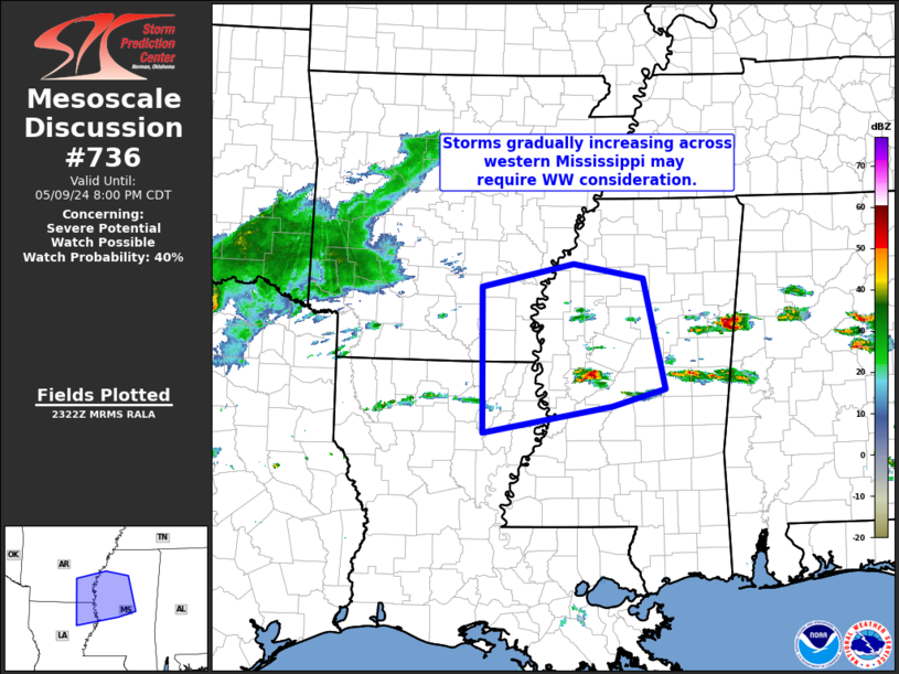
   Mesoscale Discussion 0736
   NWS Storm Prediction Center Norman OK
   0624 PM CDT Thu May 09 2024

   Areas affected...northeastern Louisiana...southeastern
   Arkansas...and west-central Mississippi

   Concerning...Severe potential...Watch possible

   Valid 092324Z - 100100Z

   Probability of Watch Issuance...40 percent

   SUMMARY...Storms continue to gradually increase across the
   west-central Mississippi Vicinity.  Additional storm development may
   require WW issuance to be considered.

   DISCUSSION...Latest radar loop shows convection gradually increasing
   in coverage and intensity across the west-central Mississippi
   vicinity, in the vicinity of a west-to-east baroclinic zone.  Though
   broad-scale ascent remains weak, the thermodynamic environment
   (characterized by 4000 to 5000 J/kg mixed-layer CAPE) remains
   strongly favorable for intense convection.  Given enhanced mid-level
   westerlies contributing to favorable shear for organized storms,
   conditional severe-weather potential may be realized across this
   region over the next few hours.  We will continue to monitor
   convective evolution, with additional development potentially
   requiring consideration of new WW issuance, or extension of
   existing/nearby watches.

   ..Goss/Hart.. 05/09/2024

   ...Please see www.spc.noaa.gov for graphic product...

   ATTN...WFO...MEG...JAN...LZK...SHV...

   LAT...LON   33919194 34209061 34018960 32678929 32469005 32139191
               33919194
|
|
Top/All Mesoscale Discussions/Forecast Products/Home
|
|


 @NWSSPC