|
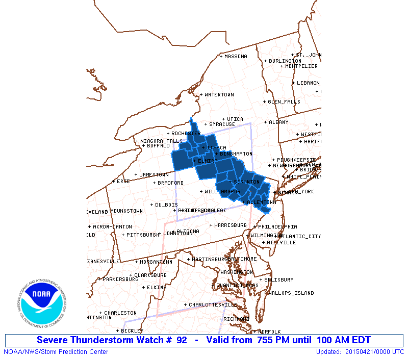
Initial List of Counties in SPC Severe Thunderstorm Watch 92 (WOU)
|
Back to Watch 92
|
 |
   WOUS64 KWNS 202354
   WOU2

   BULLETIN - IMMEDIATE BROADCAST REQUESTED
   SEVERE THUNDERSTORM WATCH OUTLINE UPDATE FOR WS 92
   NWS STORM PREDICTION CENTER NORMAN OK
   755 PM EDT MON APR 20 2015

   SEVERE THUNDERSTORM WATCH 92 IS IN EFFECT UNTIL 100 AM EDT
   FOR THE FOLLOWING LOCATIONS

   NJC019-021-027-035-037-041-210500-
   /O.NEW.KWNS.SV.A.0092.150420T2355Z-150421T0500Z/

   NJ
   .    NEW JERSEY COUNTIES INCLUDED ARE

   HUNTERDON            MERCER              MORRIS
   SOMERSET             SUSSEX              WARREN


   NYC007-011-015-023-097-099-101-107-109-123-210500-
   /O.NEW.KWNS.SV.A.0092.150420T2355Z-150421T0500Z/

   NY
   .    NEW YORK COUNTIES INCLUDED ARE

   BROOME               CAYUGA              CHEMUNG
   CORTLAND             SCHUYLER            SENECA
   STEUBEN              TIOGA               TOMPKINS
   YATES


   PAC015-025-069-079-089-095-103-115-127-131-210500-
   /O.NEW.KWNS.SV.A.0092.150420T2355Z-150421T0500Z/

   PA
   .    PENNSYLVANIA COUNTIES INCLUDED ARE

   BRADFORD             CARBON              LACKAWANNA
   LUZERNE              MONROE              NORTHAMPTON
   PIKE                 SUSQUEHANNA         WAYNE
   WYOMING


   ATTN...WFO...PHI...BGM...BUF...
|
| Aviation Watch (SAW) for WW92 |
|---|
 |
| Note:
The Aviation Watch (SAW) product is an approximation to the watch area.
The actual watch is depicted by the shaded areas. |
   SAW2
   WW 92 SEVERE TSTM NJ NY PA 202355Z - 210500Z
   AXIS..80 STATUTE MILES EAST AND WEST OF LINE..
   35NE ITH/ITHACA NY/ - 50SSE IPT/WILLIAMSPORT PA/
   ..AVIATION COORDS.. 70NM E/W /22SSE SYR - 30NE HAR/
   HAIL SURFACE AND ALOFT..1.5 INCHES. WIND GUSTS..60 KNOTS.
   MAX TOPS TO 450. MEAN STORM MOTION VECTOR 25030.

   LAT...LON 42837437 40567502 40567808 42837754

   THIS IS AN APPROXIMATION TO THE WATCH AREA.  FOR A
   COMPLETE DEPICTION OF THE WATCH SEE WOUS64 KWNS
   FOR WOU2.
|
|


 @NWSSPC