 Note:
The expiration time in the watch graphic is amended if the watch is
replaced, cancelled or extended.
Note:
Note:
The expiration time in the watch graphic is amended if the watch is
replaced, cancelled or extended.
Note: Click for
Watch Status Reports.
SEL6
URGENT - IMMEDIATE BROADCAST REQUESTED
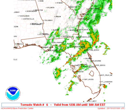
Tornado Watch Number 6
NWS Storm Prediction Center Norman OK
1235 AM EST Sat Jan 7 2017
The NWS Storm Prediction Center has issued a
* Tornado Watch for portions of
Northwest Florida
Coastal Waters
* Effective this Saturday morning from 1235 AM until 500 AM EST.
* Primary threats include...
A couple tornadoes possible
Isolated damaging wind gusts to 65 mph possible
SUMMARY...A cluster of storms over the northeast Gulf of Mexico
should spread inland across parts of northwest Florida early this
morning, with the risk of a brief tornado or two and locally
damaging winds.
The tornado watch area is approximately along and 30 statute miles
either side of a line from 50 miles northwest of Cross City FL to
105 miles south southeast of Cross City FL. For a complete depiction
of the watch see the associated watch outline update (WOUS64 KWNS
WOU6).
PRECAUTIONARY/PREPAREDNESS ACTIONS...
REMEMBER...A Tornado Watch means conditions are favorable for
tornadoes and severe thunderstorms in and close to the watch
area. Persons in these areas should be on the lookout for
threatening weather conditions and listen for later statements
and possible warnings.
&&
AVIATION...Tornadoes and a few severe thunderstorms with hail
surface and aloft to 1 inch. Extreme turbulence and surface wind
gusts to 55 knots. A few cumulonimbi with maximum tops to 500. Mean
storm motion vector 24030.
...Grams
   SEL6

   URGENT - IMMEDIATE BROADCAST REQUESTED
   Tornado Watch Number 6
   NWS Storm Prediction Center Norman OK
   1235 AM EST Sat Jan 7 2017

   The NWS Storm Prediction Center has issued a

   * Tornado Watch for portions of
     Northwest Florida
     Coastal Waters

   * Effective this Saturday morning from 1235 AM until 500 AM EST.

   * Primary threats include...
     A couple tornadoes possible
     Isolated damaging wind gusts to 65 mph possible

   SUMMARY...A cluster of storms over the northeast Gulf of Mexico
   should spread inland across parts of northwest Florida early this
   morning, with the risk of a brief tornado or two and locally
   damaging winds.

   The tornado watch area is approximately along and 30 statute miles
   either side of a line from 50 miles northwest of Cross City FL to
   105 miles south southeast of Cross City FL. For a complete depiction
   of the watch see the associated watch outline update (WOUS64 KWNS
   WOU6).

   PRECAUTIONARY/PREPAREDNESS ACTIONS...

   REMEMBER...A Tornado Watch means conditions are favorable for
   tornadoes and severe thunderstorms in and close to the watch
   area. Persons in these areas should be on the lookout for
   threatening weather conditions and listen for later statements
   and possible warnings.

   &&

   AVIATION...Tornadoes and a few severe thunderstorms with hail
   surface and aloft to 1 inch. Extreme turbulence and surface wind
   gusts to 55 knots. A few cumulonimbi with maximum tops to 500. Mean
   storm motion vector 24030.

   ...Grams
 Note:
The Aviation Watch (SAW) product is an approximation to the watch area.
The actual watch is depicted by the shaded areas.
Note:
The Aviation Watch (SAW) product is an approximation to the watch area.
The actual watch is depicted by the shaded areas.
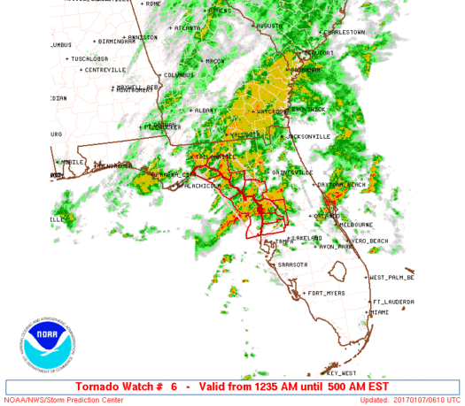
   SAW6
   WW 6 TORNADO FL CW 070535Z - 071000Z
   AXIS..30 STATUTE MILES EITHER SIDE OF LINE..
   50NW CTY/CROSS CITY FL/ - 105SSE CTY/CROSS CITY FL/
   ..AVIATION COORDS.. 25NM EITHER SIDE /43SE TLH - 23NE PIE/
   HAIL SURFACE AND ALOFT..1 INCH. WIND GUSTS..55 KNOTS.
   MAX TOPS TO 500. MEAN STORM MOTION VECTOR 24030.

   LAT...LON 30388327 28478204 27968283 29888409

   THIS IS AN APPROXIMATION TO THE WATCH AREA.  FOR A
   COMPLETE DEPICTION OF THE WATCH SEE WOUS64 KWNS
   FOR WOU6.
Watch 6 Status Report Messages:
STATUS REPORT #1 ON WW 6

VALID 070831Z - 070940Z

SEVERE WEATHER THREAT CONTINUES RIGHT OF A LINE FROM 65 NW PIE TO
20 WNW OCF.

MESOSCALE DISCUSSION FORTHCOMING.

..EDWARDS..01/07/17

ATTN...WFO...TBW...TAE...

&&

STATUS REPORT FOR WT 6

SEVERE WEATHER THREAT CONTINUES FOR THE FOLLOWING AREAS

FLC017-053-057-075-081-101-103-115-119-070940-

FL
.    FLORIDA COUNTIES INCLUDED ARE

CITRUS		     HERNANDO		 HILLSBOROUGH
LEVY		     MANATEE		 PASCO
PINELLAS	     SARASOTA		 SUMTER
$$


GMZ830-850-853-070940-

CW

.    ADJACENT COASTAL WATERS INCLUDED ARE

TAMPA BAY WATERS

COASTAL WATERS FROM TARPON SPRINGS TO SUWANNEE RIVER FL OUT 20 NM

COASTAL WATERS FROM ENGLEWOOD TO TARPON SPRINGS FL OUT 20 NM

$$
THE WATCH STATUS MESSAGE IS FOR GUIDANCE PURPOSES ONLY.  PLEASE
REFER TO WATCH COUNTY NOTIFICATION STATEMENTS FOR OFFICIAL
INFORMATION ON COUNTIES...INDEPENDENT CITIES AND MARINE ZONES
CLEARED FROM SEVERE THUNDERSTORM AND TORNADO WATCHES.
$$
Note:
Click for Complete Product Text.
Tornadoes
Probability of 2 or more tornadoes
|
Mod (30%)
|
Probability of 1 or more strong (F2-F5) tornadoes
|
Low (20%)
|
Wind
Probability of 10 or more severe wind events
|
Low (20%)
|
Probability of 1 or more wind events > 65 knots
|
Low (10%)
|
Hail
Probability of 10 or more severe hail events
|
Low (10%)
|
Probability of 1 or more hailstones > 2 inches
|
Low (<5%)
|
Combined Severe Hail/Wind
Probability of 6 or more combined severe hail/wind events
|
Mod (30%)
|
For each watch, probabilities for particular events inside the watch
(listed above in each table) are determined by the issuing forecaster.
The "Low" category contains probability values ranging from less than 2%
to 20% (F2-F5 tornadoes), less than 5% to 20% (all other probabilities),
"Moderate" from 30% to 60%, and "High" from 70% to greater than 95%.
High values are bolded and lighter in color to provide awareness of
an increased threat for a particular event.


 @NWSSPC


