 Note:
The expiration time in the watch graphic is amended if the watch is
replaced, cancelled or extended.
Note:
Note:
The expiration time in the watch graphic is amended if the watch is
replaced, cancelled or extended.
Note: Click for
Watch Status Reports.
SEL8
URGENT - IMMEDIATE BROADCAST REQUESTED
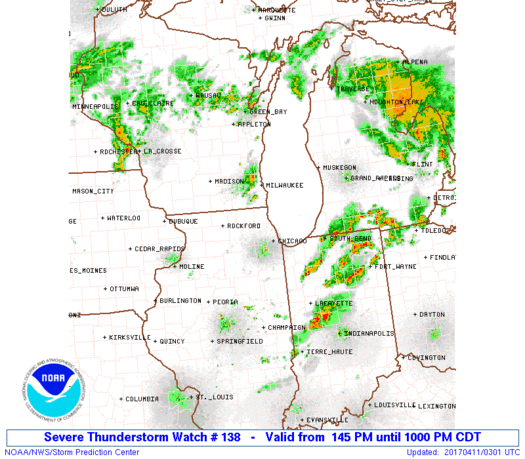
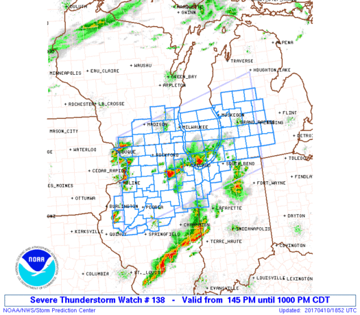
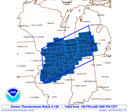
Severe Thunderstorm Watch Number 138
NWS Storm Prediction Center Norman OK
145 PM CDT Mon Apr 10 2017
The NWS Storm Prediction Center has issued a
* Severe Thunderstorm Watch for portions of
Northern and central Illinois
Northwest Indiana
Southwest Lower Michigan
Southern Wisconsin
Lake Michigan
* Effective this Monday afternoon and evening from 145 PM until
1000 PM CDT.
* Primary threats include...
Scattered damaging winds and isolated significant gusts to 75
mph possible
Scattered large hail and isolated very large hail events to 2
inches in diameter possible
A tornado or two possible
SUMMARY...Increasingly scattered storms are expected along and ahead
of a cold front into this evening, which may develop into a
fast-moving cluster. Severe hail and damaging winds are the primary
hazards.
The severe thunderstorm watch area is approximately along and 100
statute miles north and south of a line from 5 miles south of Moline
IL to 40 miles east of Grand Rapids MI. For a complete depiction of
the watch see the associated watch outline update (WOUS64 KWNS
WOU8).
PRECAUTIONARY/PREPAREDNESS ACTIONS...
REMEMBER...A Severe Thunderstorm Watch means conditions are
favorable for severe thunderstorms in and close to the watch area.
Persons in these areas should be on the lookout for threatening
weather conditions and listen for later statements and possible
warnings. Severe thunderstorms can and occasionally do produce
tornadoes.
&&
AVIATION...A few severe thunderstorms with hail surface and aloft to
2 inches. Extreme turbulence and surface wind gusts to 65 knots. A
few cumulonimbi with maximum tops to 500. Mean storm motion vector
24035.
...Grams
   SEL8

   URGENT - IMMEDIATE BROADCAST REQUESTED
   Severe Thunderstorm Watch Number 138
   NWS Storm Prediction Center Norman OK
   145 PM CDT Mon Apr 10 2017

   The NWS Storm Prediction Center has issued a

   * Severe Thunderstorm Watch for portions of
     Northern and central Illinois
     Northwest Indiana
     Southwest Lower Michigan
     Southern Wisconsin
     Lake Michigan

   * Effective this Monday afternoon and evening from 145 PM until
     1000 PM CDT.

   * Primary threats include...
     Scattered damaging winds and isolated significant gusts to 75
       mph possible
     Scattered large hail and isolated very large hail events to 2
       inches in diameter possible
     A tornado or two possible

   SUMMARY...Increasingly scattered storms are expected along and ahead
   of a cold front into this evening, which may develop into a
   fast-moving cluster. Severe hail and damaging winds are the primary
   hazards.

   The severe thunderstorm watch area is approximately along and 100
   statute miles north and south of a line from 5 miles south of Moline
   IL to 40 miles east of Grand Rapids MI. For a complete depiction of
   the watch see the associated watch outline update (WOUS64 KWNS
   WOU8).

   PRECAUTIONARY/PREPAREDNESS ACTIONS...

   REMEMBER...A Severe Thunderstorm Watch means conditions are
   favorable for severe thunderstorms in and close to the watch area.
   Persons in these areas should be on the lookout for threatening
   weather conditions and listen for later statements and possible
   warnings. Severe thunderstorms can and occasionally do produce
   tornadoes.

   &&

   AVIATION...A few severe thunderstorms with hail surface and aloft to
   2 inches. Extreme turbulence and surface wind gusts to 65 knots. A
   few cumulonimbi with maximum tops to 500. Mean storm motion vector
   24035.

   ...Grams
 Note:
The Aviation Watch (SAW) product is an approximation to the watch area.
The actual watch is depicted by the shaded areas.
Note:
The Aviation Watch (SAW) product is an approximation to the watch area.
The actual watch is depicted by the shaded areas.
   SAW8
   WW 138 SEVERE TSTM IL IN MI WI LM 101845Z - 110300Z
   AXIS..100 STATUTE MILES NORTH AND SOUTH OF LINE..
   5S MLI/MOLINE IL/ - 40E GRR/GRAND RAPIDS MI/
   ..AVIATION COORDS.. 85NM N/S /43WNW BDF - 34E GRR/
   HAIL SURFACE AND ALOFT..2 INCHES. WIND GUSTS..65 KNOTS.
   MAX TOPS TO 500. MEAN STORM MOTION VECTOR 24035.

   LAT...LON 42819050 44318473 41438473 39939050

   THIS IS AN APPROXIMATION TO THE WATCH AREA.  FOR A
   COMPLETE DEPICTION OF THE WATCH SEE WOUS64 KWNS
   FOR WOU8.
Watch 138 Status Report Messages:
STATUS REPORT #7 ON WW 138

VALID 110225Z - 110300Z

SEVERE WEATHER THREAT CONTINUES RIGHT OF A LINE FROM 10 NE SLO TO
15 NNE CMI TO 25 NNE VPZ TO 25 W AZO TO 30 SW LAN TO 25 NW ARB.

WW 138 WILL BE ALLOWED TO EXPIRE AT 110300Z.

FOR ADDITIONAL INFORMATION SEE MESOSCALE DISCUSSION 481

..COOK..04/11/17

ATTN...WFO...LOT...DVN...ILX...IWX...GRR...MKX...

&&

STATUS REPORT FOR WS 138

SEVERE WEATHER THREAT CONTINUES FOR THE FOLLOWING AREAS

ILC029-035-041-045-053-075-091-183-110300-

IL
.    ILLINOIS COUNTIES INCLUDED ARE

COLES		     CUMBERLAND 	 DOUGLAS
EDGAR		     FORD		 IROQUOIS
KANKAKEE	     VERMILION
$$


INC007-073-089-111-127-110300-

IN
.    INDIANA COUNTIES INCLUDED ARE

BENTON		     JASPER		 LAKE
NEWTON		     PORTER
$$


MIC015-025-037-045-065-067-075-110300-

MI
.    MICHIGAN COUNTIES INCLUDED ARE

BARRY		     CALHOUN		 CLINTON
EATON		     INGHAM		 IONIA
JACKSON
$$


THE WATCH STATUS MESSAGE IS FOR GUIDANCE PURPOSES ONLY.  PLEASE
REFER TO WATCH COUNTY NOTIFICATION STATEMENTS FOR OFFICIAL
INFORMATION ON COUNTIES...INDEPENDENT CITIES AND MARINE ZONES
CLEARED FROM SEVERE THUNDERSTORM AND TORNADO WATCHES.
$$

STATUS REPORT #6 ON WW 138

VALID 110140Z - 110240Z

SEVERE WEATHER THREAT CONTINUES RIGHT OF A LINE FROM 35 ENE ALN
TO 15 SW DEC TO 40 NE BMI TO 40 NNW VPZ TO 15 NNW GRR TO 10 NNE
MBS.

..COOK..04/11/17

ATTN...WFO...LOT...DVN...ILX...IWX...GRR...MKX...

&&

STATUS REPORT FOR WS 138

SEVERE WEATHER THREAT CONTINUES FOR THE FOLLOWING AREAS

ILC019-021-029-035-041-045-049-053-075-091-115-139-147-173-183-
110240-

IL
.    ILLINOIS COUNTIES INCLUDED ARE

CHAMPAIGN	     CHRISTIAN		 COLES
CUMBERLAND	     DOUGLAS		 EDGAR
EFFINGHAM	     FORD		 IROQUOIS
KANKAKEE	     MACON		 MOULTRIE
PIATT		     SHELBY		 VERMILION
$$


INC007-073-089-111-127-110240-

IN
.    INDIANA COUNTIES INCLUDED ARE

BENTON		     JASPER		 LAKE
NEWTON		     PORTER
$$


MIC005-015-025-037-045-065-067-075-077-159-110240-

MI
.    MICHIGAN COUNTIES INCLUDED ARE

ALLEGAN 	     BARRY		 CALHOUN
CLINTON 	     EATON		 INGHAM
IONIA		     JACKSON		 KALAMAZOO
VAN BUREN
$$


THE WATCH STATUS MESSAGE IS FOR GUIDANCE PURPOSES ONLY.  PLEASE
REFER TO WATCH COUNTY NOTIFICATION STATEMENTS FOR OFFICIAL
INFORMATION ON COUNTIES...INDEPENDENT CITIES AND MARINE ZONES
CLEARED FROM SEVERE THUNDERSTORM AND TORNADO WATCHES.
$$

STATUS REPORT #5 ON WW 138

VALID 110035Z - 110140Z

SEVERE WEATHER THREAT CONTINUES RIGHT OF A LINE FROM 20 SW SPI TO
20 SE PIA TO 35 ESE RFD TO 20 ENE MKE TO 5 SE MBL AND 30 SSW SPI
TO 15 SSW BMI TO 25 SSE MMO TO 35 S RAC TO 30 WSW MKG TO 35 WSW
HTL.

..COOK..04/11/17

ATTN...WFO...LOT...DVN...ILX...IWX...GRR...MKX...

&&

STATUS REPORT FOR WS 138

SEVERE WEATHER THREAT CONTINUES FOR THE FOLLOWING AREAS

ILC019-021-029-035-041-045-049-053-075-091-115-139-147-173-183-
110140-

IL
.    ILLINOIS COUNTIES INCLUDED ARE

CHAMPAIGN	     CHRISTIAN		 COLES
CUMBERLAND	     DOUGLAS		 EDGAR
EFFINGHAM	     FORD		 IROQUOIS
KANKAKEE	     MACON		 MOULTRIE
PIATT		     SHELBY		 VERMILION
$$


INC007-073-089-111-127-110140-

IN
.    INDIANA COUNTIES INCLUDED ARE

BENTON		     JASPER		 LAKE
NEWTON		     PORTER
$$


MIC005-015-025-037-045-057-065-067-073-075-077-081-107-117-121-
123-139-159-110140-

MI
.    MICHIGAN COUNTIES INCLUDED ARE

ALLEGAN 	     BARRY		 CALHOUN
CLINTON 	     EATON		 GRATIOT
INGHAM		     IONIA		 ISABELLA
JACKSON 	     KALAMAZOO		 KENT
MECOSTA 	     MONTCALM		 MUSKEGON
NEWAYGO 	     OTTAWA		 VAN BUREN
$$


LMZ844-845-846-847-872-874-876-878-110140-

CW

.    ADJACENT COASTAL WATERS INCLUDED ARE

ST JOSEPH TO SOUTH HAVEN MI

SOUTH HAVEN TO HOLLAND MI

HOLLAND TO GRAND HAVEN MI

GRAND HAVEN TO WHITEHALL MI

LAKE MICHIGAN FROM GRAND HAVEN TO WHITEHALL MI 5NM OFFSHORE TO
MID LAKE

LAKE MICHIGAN FROM HOLLAND TO GRAND HAVEN MI 5NM OFFSHORE TO MID
LAKE

LAKE MICHIGAN FROM SOUTH HAVEN TO HOLLAND MI 5NM OFFSHORE TO MID
LAKE

LAKE MICHIGAN FROM ST JOSEPH TO SOUTH HAVEN MI 5NM OFFSHORE TO
MID LAKE

$$
THE WATCH STATUS MESSAGE IS FOR GUIDANCE PURPOSES ONLY.  PLEASE
REFER TO WATCH COUNTY NOTIFICATION STATEMENTS FOR OFFICIAL
INFORMATION ON COUNTIES...INDEPENDENT CITIES AND MARINE ZONES
CLEARED FROM SEVERE THUNDERSTORM AND TORNADO WATCHES.
$$

STATUS REPORT #4 ON WW 138

VALID 102325Z - 110040Z

SEVERE WEATHER THREAT CONTINUES RIGHT OF A LINE FROM 20 SW SPI TO
20 SE PIA TO 35 ESE RFD TO 20 ENE MKE TO 5 SE MBL.

FOR ADDITIONAL INFORMATION SEE MESOSCALE DISCUSSION 479

..COOK..04/10/17

ATTN...WFO...LOT...DVN...ILX...IWX...GRR...MKX...

&&

STATUS REPORT FOR WS 138

SEVERE WEATHER THREAT CONTINUES FOR THE FOLLOWING AREAS

ILC019-021-031-037-039-043-053-063-075-089-091-093-097-099-105-
107-113-115-147-167-183-197-110040-

IL
.    ILLINOIS COUNTIES INCLUDED ARE

CHAMPAIGN	     CHRISTIAN		 COOK
DE KALB 	     DE WITT		 DUPAGE
FORD		     GRUNDY		 IROQUOIS
KANE		     KANKAKEE		 KENDALL
LAKE		     LA SALLE		 LIVINGSTON
LOGAN		     MCLEAN		 MACON
PIATT		     SANGAMON		 VERMILION
WILL
$$


INC007-073-089-091-111-127-141-149-110040-

IN
.    INDIANA COUNTIES INCLUDED ARE

BENTON		     JASPER		 LAKE
LA PORTE	     NEWTON		 PORTER
ST. JOSEPH	     STARKE
$$


MIC005-015-021-023-025-027-037-045-057-065-067-073-075-077-081-
107-117-121-123-139-149-159-110040-

MI
.    MICHIGAN COUNTIES INCLUDED ARE

ALLEGAN 	     BARRY		 BERRIEN
BRANCH		     CALHOUN		 CASS
CLINTON 	     EATON		 GRATIOT
INGHAM		     IONIA		 ISABELLA
JACKSON 	     KALAMAZOO		 KENT
MECOSTA 	     MONTCALM		 MUSKEGON
NEWAYGO 	     OTTAWA		 ST. JOSEPH
VAN BUREN
$$


LMZ043-046-080-673-675-740-741-742-743-744-745-777-779-844-845-
846-847-872-874-876-878-110040-

CW

.    ADJACENT COASTAL WATERS INCLUDED ARE

NEW BUFFALO MI TO ST JOSEPH MI

MICHIGAN CITY IN TO NEW BUFFALO MI

LAKE MICHIGAN MICHIGAN CITY IN TO ST. JOSEPH MI 5 NM OFFSHORE TO
MID-LINE OF LAKE.

LAKE MICHIGAN FROM NORTH POINT LIGHT TO WIND POINT WI 5NM
OFFSHORE TO MID LAKE

LAKE MICHIGAN FROM WIND POINT WI TO WINTHROP HARBOR IL 5NM
OFFSHORE TO MID LAKE

WINTHROP HARBOR TO WILMETTE HARBOR IL

WILMETTE HARBOR TO NORTHERLY ISLAND IL

NORTHERLY ISLAND TO CALUMET HARBOR IL

CALUMET HARBOR IL TO GARY IN

GARY TO BURNS HARBOR IN

BURNS HARBOR TO MICHIGAN CITY IN

LAKE MICHIGAN FROM WINTHROP HARBOR TO WILMETTE HARBOR IL 5NM
OFFSHORE TO MID LAKE

LAKE MICHIGAN FROM WILMETTE HARBOR TO MICHIGAN CITY IN 5NM
OFFSHORE TO MID LAKE

ST JOSEPH TO SOUTH HAVEN MI

SOUTH HAVEN TO HOLLAND MI

HOLLAND TO GRAND HAVEN MI

GRAND HAVEN TO WHITEHALL MI

LAKE MICHIGAN FROM GRAND HAVEN TO WHITEHALL MI 5NM OFFSHORE TO
MID LAKE

LAKE MICHIGAN FROM HOLLAND TO GRAND HAVEN MI 5NM OFFSHORE TO MID
LAKE

LAKE MICHIGAN FROM SOUTH HAVEN TO HOLLAND MI 5NM OFFSHORE TO MID
LAKE

LAKE MICHIGAN FROM ST JOSEPH TO SOUTH HAVEN MI 5NM OFFSHORE TO
MID LAKE

$$
THE WATCH STATUS MESSAGE IS FOR GUIDANCE PURPOSES ONLY.  PLEASE
REFER TO WATCH COUNTY NOTIFICATION STATEMENTS FOR OFFICIAL
INFORMATION ON COUNTIES...INDEPENDENT CITIES AND MARINE ZONES
CLEARED FROM SEVERE THUNDERSTORM AND TORNADO WATCHES.
$$

STATUS REPORT #3 ON WW 138

VALID 102235Z - 102340Z

SEVERE WEATHER THREAT CONTINUES RIGHT OF A LINE FROM 20 WNW SPI
TO 20 S PIA TO 35 NE PIA TO 25 SSE RFD TO 5 S JVL TO 10 WNW MSN.

..COOK..04/10/17

ATTN...WFO...LOT...DVN...ILX...IWX...GRR...MKX...

&&

STATUS REPORT FOR WS 138

SEVERE WEATHER THREAT CONTINUES FOR THE FOLLOWING AREAS

ILC019-021-031-037-039-043-053-063-075-089-091-093-097-099-105-
107-113-115-147-167-183-197-102340-

IL
.    ILLINOIS COUNTIES INCLUDED ARE

CHAMPAIGN	     CHRISTIAN		 COOK
DE KALB 	     DE WITT		 DUPAGE
FORD		     GRUNDY		 IROQUOIS
KANE		     KANKAKEE		 KENDALL
LAKE		     LA SALLE		 LIVINGSTON
LOGAN		     MCLEAN		 MACON
PIATT		     SANGAMON		 VERMILION
WILL
$$


INC007-073-089-091-111-127-141-149-102340-

IN
.    INDIANA COUNTIES INCLUDED ARE

BENTON		     JASPER		 LAKE
LA PORTE	     NEWTON		 PORTER
ST. JOSEPH	     STARKE
$$


MIC005-015-021-023-025-027-037-045-057-065-067-073-075-077-081-
107-117-121-123-139-149-159-102340-

MI
.    MICHIGAN COUNTIES INCLUDED ARE

ALLEGAN 	     BARRY		 BERRIEN
BRANCH		     CALHOUN		 CASS
CLINTON 	     EATON		 GRATIOT
INGHAM		     IONIA		 ISABELLA
JACKSON 	     KALAMAZOO		 KENT
MECOSTA 	     MONTCALM		 MUSKEGON
NEWAYGO 	     OTTAWA		 ST. JOSEPH
VAN BUREN
$$


LMZ043-046-080-673-675-740-741-742-743-744-745-777-779-844-845-
846-847-872-874-876-878-102340-

CW

.    ADJACENT COASTAL WATERS INCLUDED ARE

NEW BUFFALO MI TO ST JOSEPH MI

MICHIGAN CITY IN TO NEW BUFFALO MI

LAKE MICHIGAN MICHIGAN CITY IN TO ST. JOSEPH MI 5 NM OFFSHORE TO
MID-LINE OF LAKE.

LAKE MICHIGAN FROM NORTH POINT LIGHT TO WIND POINT WI 5NM
OFFSHORE TO MID LAKE

LAKE MICHIGAN FROM WIND POINT WI TO WINTHROP HARBOR IL 5NM
OFFSHORE TO MID LAKE

WINTHROP HARBOR TO WILMETTE HARBOR IL

WILMETTE HARBOR TO NORTHERLY ISLAND IL

NORTHERLY ISLAND TO CALUMET HARBOR IL

CALUMET HARBOR IL TO GARY IN

GARY TO BURNS HARBOR IN

BURNS HARBOR TO MICHIGAN CITY IN

LAKE MICHIGAN FROM WINTHROP HARBOR TO WILMETTE HARBOR IL 5NM
OFFSHORE TO MID LAKE

LAKE MICHIGAN FROM WILMETTE HARBOR TO MICHIGAN CITY IN 5NM
OFFSHORE TO MID LAKE

ST JOSEPH TO SOUTH HAVEN MI

SOUTH HAVEN TO HOLLAND MI

HOLLAND TO GRAND HAVEN MI

GRAND HAVEN TO WHITEHALL MI

LAKE MICHIGAN FROM GRAND HAVEN TO WHITEHALL MI 5NM OFFSHORE TO
MID LAKE

LAKE MICHIGAN FROM HOLLAND TO GRAND HAVEN MI 5NM OFFSHORE TO MID
LAKE

LAKE MICHIGAN FROM SOUTH HAVEN TO HOLLAND MI 5NM OFFSHORE TO MID
LAKE

LAKE MICHIGAN FROM ST JOSEPH TO SOUTH HAVEN MI 5NM OFFSHORE TO
MID LAKE

$$
THE WATCH STATUS MESSAGE IS FOR GUIDANCE PURPOSES ONLY.  PLEASE
REFER TO WATCH COUNTY NOTIFICATION STATEMENTS FOR OFFICIAL
INFORMATION ON COUNTIES...INDEPENDENT CITIES AND MARINE ZONES
CLEARED FROM SEVERE THUNDERSTORM AND TORNADO WATCHES.
$$

STATUS REPORT #2 ON WW 138

VALID 102130Z - 102240Z

SEVERE WEATHER THREAT CONTINUES RIGHT OF A LINE FROM 25 WNW SPI
TO 35 N PIA TO 20 NW RFD TO 15 W MSN.

FOR ADDITIONAL INFORMATION SEE MESOSCALE DISCUSSION 477

..COHEN..04/10/17

ATTN...WFO...LOT...DVN...ILX...IWX...GRR...MKX...

&&

STATUS REPORT FOR WS 138

SEVERE WEATHER THREAT CONTINUES FOR THE FOLLOWING AREAS

ILC007-011-019-021-031-037-039-043-053-063-075-089-091-093-097-
099-103-105-107-111-113-115-123-125-129-141-143-147-155-167-175-
179-183-197-201-203-102240-

IL
.    ILLINOIS COUNTIES INCLUDED ARE

BOONE		     BUREAU		 CHAMPAIGN
CHRISTIAN	     COOK		 DE KALB
DE WITT 	     DUPAGE		 FORD
GRUNDY		     IROQUOIS		 KANE
KANKAKEE	     KENDALL		 LAKE
LA SALLE	     LEE		 LIVINGSTON
LOGAN		     MCHENRY		 MCLEAN
MACON		     MARSHALL		 MASON
MENARD		     OGLE		 PEORIA
PIATT		     PUTNAM		 SANGAMON
STARK		     TAZEWELL		 VERMILION
WILL		     WINNEBAGO		 WOODFORD
$$


INC007-073-089-091-111-127-141-149-102240-

IN
.    INDIANA COUNTIES INCLUDED ARE

BENTON		     JASPER		 LAKE
LA PORTE	     NEWTON		 PORTER
ST. JOSEPH	     STARKE
$$


MIC005-015-021-023-025-027-037-045-057-065-067-073-075-077-081-
107-117-121-123-139-149-159-102240-

MI
.    MICHIGAN COUNTIES INCLUDED ARE

ALLEGAN 	     BARRY		 BERRIEN
BRANCH		     CALHOUN		 CASS
CLINTON 	     EATON		 GRATIOT
INGHAM		     IONIA		 ISABELLA
JACKSON 	     KALAMAZOO		 KENT
MECOSTA 	     MONTCALM		 MUSKEGON
NEWAYGO 	     OTTAWA		 ST. JOSEPH
VAN BUREN
$$


WIC025-027-055-059-079-089-101-105-127-131-133-102240-

WI
.    WISCONSIN COUNTIES INCLUDED ARE

DANE		     DODGE		 JEFFERSON
KENOSHA 	     MILWAUKEE		 OZAUKEE
RACINE		     ROCK		 WALWORTH
WASHINGTON	     WAUKESHA
$$


LMZ043-046-080-644-645-646-671-673-675-740-741-742-743-744-745-
777-779-844-845-846-847-872-874-876-878-102240-

CW

.    ADJACENT COASTAL WATERS INCLUDED ARE

NEW BUFFALO MI TO ST JOSEPH MI

MICHIGAN CITY IN TO NEW BUFFALO MI

LAKE MICHIGAN MICHIGAN CITY IN TO ST. JOSEPH MI 5 NM OFFSHORE TO
MID-LINE OF LAKE.

PORT WASHINGTON TO NORTH POINT LIGHT WI

NORTH POINT LIGHT TO WIND POINT WI

WIND POINT WI TO WINTHROP HARBOR IL

LAKE MICHIGAN FROM PORT WASHINGTON TO NORTH POINT LIGHT WI 5NM
OFFSHORE TO MID LAKE

LAKE MICHIGAN FROM NORTH POINT LIGHT TO WIND POINT WI 5NM
OFFSHORE TO MID LAKE

LAKE MICHIGAN FROM WIND POINT WI TO WINTHROP HARBOR IL 5NM
OFFSHORE TO MID LAKE

WINTHROP HARBOR TO WILMETTE HARBOR IL

WILMETTE HARBOR TO NORTHERLY ISLAND IL

NORTHERLY ISLAND TO CALUMET HARBOR IL

CALUMET HARBOR IL TO GARY IN

GARY TO BURNS HARBOR IN

BURNS HARBOR TO MICHIGAN CITY IN

LAKE MICHIGAN FROM WINTHROP HARBOR TO WILMETTE HARBOR IL 5NM
OFFSHORE TO MID LAKE

LAKE MICHIGAN FROM WILMETTE HARBOR TO MICHIGAN CITY IN 5NM
OFFSHORE TO MID LAKE

ST JOSEPH TO SOUTH HAVEN MI

SOUTH HAVEN TO HOLLAND MI

HOLLAND TO GRAND HAVEN MI

GRAND HAVEN TO WHITEHALL MI

LAKE MICHIGAN FROM GRAND HAVEN TO WHITEHALL MI 5NM OFFSHORE TO
MID LAKE

LAKE MICHIGAN FROM HOLLAND TO GRAND HAVEN MI 5NM OFFSHORE TO MID
LAKE

LAKE MICHIGAN FROM SOUTH HAVEN TO HOLLAND MI 5NM OFFSHORE TO MID
LAKE

LAKE MICHIGAN FROM ST JOSEPH TO SOUTH HAVEN MI 5NM OFFSHORE TO
MID LAKE

$$
THE WATCH STATUS MESSAGE IS FOR GUIDANCE PURPOSES ONLY.  PLEASE
REFER TO WATCH COUNTY NOTIFICATION STATEMENTS FOR OFFICIAL
INFORMATION ON COUNTIES...INDEPENDENT CITIES AND MARINE ZONES
CLEARED FROM SEVERE THUNDERSTORM AND TORNADO WATCHES.
$$

STATUS REPORT #1 ON WW 138

VALID 102030Z - 102140Z

SEVERE WEATHER THREAT CONTINUES RIGHT OF A LINE FROM 35 W SPI TO
40 ENE MLI TO 45 WSW JVL TO 20 S LNR.

FOR ADDITIONAL INFORMATION SEE MESOSCALE DISCUSSION 477

..COHEN..04/10/17

ATTN...WFO...LOT...DVN...ILX...IWX...GRR...MKX...

&&

STATUS REPORT FOR WS 138

SEVERE WEATHER THREAT CONTINUES FOR THE FOLLOWING AREAS

ILC007-011-017-031-037-039-043-053-057-063-075-089-091-093-095-
097-099-103-105-107-111-113-123-125-129-141-143-155-175-179-197-
201-203-102140-

IL
.    ILLINOIS COUNTIES INCLUDED ARE

BOONE		     BUREAU		 CASS
COOK		     DE KALB		 DE WITT
DUPAGE		     FORD		 FULTON
GRUNDY		     IROQUOIS		 KANE
KANKAKEE	     KENDALL		 KNOX
LAKE		     LA SALLE		 LEE
LIVINGSTON	     LOGAN		 MCHENRY
MCLEAN		     MARSHALL		 MASON
MENARD		     OGLE		 PEORIA
PUTNAM		     STARK		 TAZEWELL
WILL		     WINNEBAGO		 WOODFORD
$$


INC007-073-089-091-111-127-141-149-102140-

IN
.    INDIANA COUNTIES INCLUDED ARE

BENTON		     JASPER		 LAKE
LA PORTE	     NEWTON		 PORTER
ST. JOSEPH	     STARKE
$$


MIC005-015-021-023-025-027-037-045-057-065-067-073-075-077-081-
107-117-121-123-139-149-159-102140-

MI
.    MICHIGAN COUNTIES INCLUDED ARE

ALLEGAN 	     BARRY		 BERRIEN
BRANCH		     CALHOUN		 CASS
CLINTON 	     EATON		 GRATIOT
INGHAM		     IONIA		 ISABELLA
JACKSON 	     KALAMAZOO		 KENT
MECOSTA 	     MONTCALM		 MUSKEGON
NEWAYGO 	     OTTAWA		 ST. JOSEPH
VAN BUREN
$$


WIC025-027-045-055-059-079-089-101-105-127-131-133-102140-

WI
.    WISCONSIN COUNTIES INCLUDED ARE

DANE		     DODGE		 GREEN
JEFFERSON	     KENOSHA		 MILWAUKEE
OZAUKEE 	     RACINE		 ROCK
WALWORTH	     WASHINGTON 	 WAUKESHA
$$


LMZ043-046-080-644-645-646-671-673-675-740-741-742-743-744-745-
777-779-844-845-846-847-872-874-876-878-102140-

CW

.    ADJACENT COASTAL WATERS INCLUDED ARE

NEW BUFFALO MI TO ST JOSEPH MI

MICHIGAN CITY IN TO NEW BUFFALO MI

LAKE MICHIGAN MICHIGAN CITY IN TO ST. JOSEPH MI 5 NM OFFSHORE TO
MID-LINE OF LAKE.

PORT WASHINGTON TO NORTH POINT LIGHT WI

NORTH POINT LIGHT TO WIND POINT WI

WIND POINT WI TO WINTHROP HARBOR IL

LAKE MICHIGAN FROM PORT WASHINGTON TO NORTH POINT LIGHT WI 5NM
OFFSHORE TO MID LAKE

LAKE MICHIGAN FROM NORTH POINT LIGHT TO WIND POINT WI 5NM
OFFSHORE TO MID LAKE

LAKE MICHIGAN FROM WIND POINT WI TO WINTHROP HARBOR IL 5NM
OFFSHORE TO MID LAKE

WINTHROP HARBOR TO WILMETTE HARBOR IL

WILMETTE HARBOR TO NORTHERLY ISLAND IL

NORTHERLY ISLAND TO CALUMET HARBOR IL

CALUMET HARBOR IL TO GARY IN

GARY TO BURNS HARBOR IN

BURNS HARBOR TO MICHIGAN CITY IN

LAKE MICHIGAN FROM WINTHROP HARBOR TO WILMETTE HARBOR IL 5NM
OFFSHORE TO MID LAKE

LAKE MICHIGAN FROM WILMETTE HARBOR TO MICHIGAN CITY IN 5NM
OFFSHORE TO MID LAKE

ST JOSEPH TO SOUTH HAVEN MI

SOUTH HAVEN TO HOLLAND MI

HOLLAND TO GRAND HAVEN MI

GRAND HAVEN TO WHITEHALL MI

LAKE MICHIGAN FROM GRAND HAVEN TO WHITEHALL MI 5NM OFFSHORE TO
MID LAKE

LAKE MICHIGAN FROM HOLLAND TO GRAND HAVEN MI 5NM OFFSHORE TO MID
LAKE

LAKE MICHIGAN FROM SOUTH HAVEN TO HOLLAND MI 5NM OFFSHORE TO MID
LAKE

LAKE MICHIGAN FROM ST JOSEPH TO SOUTH HAVEN MI 5NM OFFSHORE TO
MID LAKE

$$
THE WATCH STATUS MESSAGE IS FOR GUIDANCE PURPOSES ONLY.  PLEASE
REFER TO WATCH COUNTY NOTIFICATION STATEMENTS FOR OFFICIAL
INFORMATION ON COUNTIES...INDEPENDENT CITIES AND MARINE ZONES
CLEARED FROM SEVERE THUNDERSTORM AND TORNADO WATCHES.
$$
Note:
Click for Complete Product Text.
Tornadoes
Probability of 2 or more tornadoes
|
Low (20%)
|
Probability of 1 or more strong (F2-F5) tornadoes
|
Low (10%)
|
Wind
Probability of 10 or more severe wind events
|
Mod (40%)
|
Probability of 1 or more wind events > 65 knots
|
Mod (30%)
|
Hail
Probability of 10 or more severe hail events
|
Mod (40%)
|
Probability of 1 or more hailstones > 2 inches
|
Mod (30%)
|
Combined Severe Hail/Wind
Probability of 6 or more combined severe hail/wind events
|
High (70%)
|
For each watch, probabilities for particular events inside the watch
(listed above in each table) are determined by the issuing forecaster.
The "Low" category contains probability values ranging from less than 2%
to 20% (F2-F5 tornadoes), less than 5% to 20% (all other probabilities),
"Moderate" from 30% to 60%, and "High" from 70% to greater than 95%.
High values are bolded and lighter in color to provide awareness of
an increased threat for a particular event.


 @NWSSPC


