Note:
The expiration time in the watch graphic is amended if the watch is
replaced, cancelled or extended.
Note:
Note:
The expiration time in the watch graphic is amended if the watch is
replaced, cancelled or extended.
Note: Click for
Watch Status Reports.
SEL4
URGENT - IMMEDIATE BROADCAST REQUESTED
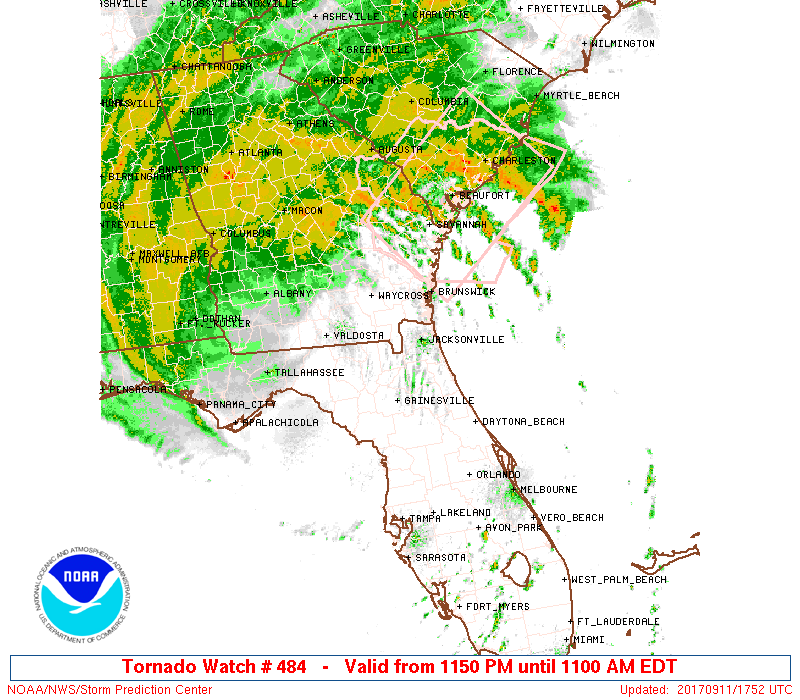
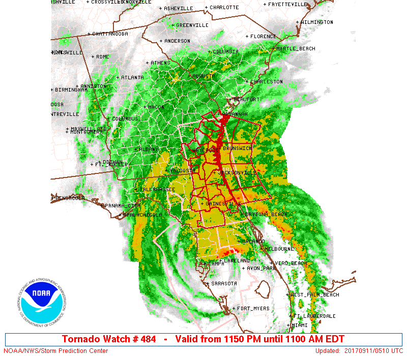
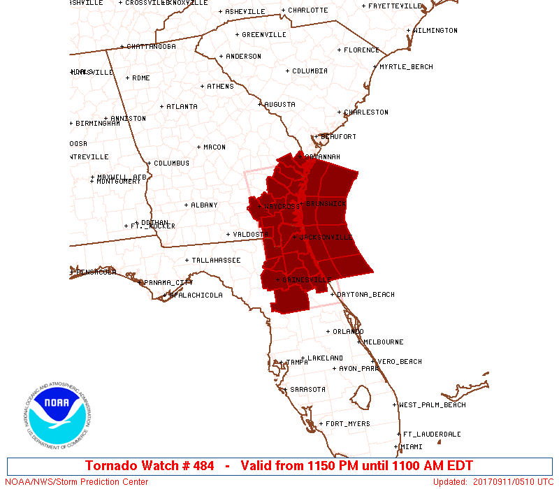
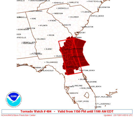
Tornado Watch Number 484
NWS Storm Prediction Center Norman OK
1150 PM EDT Sun Sep 10 2017
The NWS Storm Prediction Center has issued a
* Tornado Watch for portions of
Northeast Florida
Southeast Georgia
Coastal Waters
* Effective this Sunday night and Monday morning from 1150 PM
until 1100 AM EDT.
* Primary threats include...
A couple tornadoes possible
SUMMARY...The risk for a couple tornadoes will persist as Tropical
Cyclone Irma moves north this morning.
The tornado watch area is approximately along and 45 statute miles
east and west of a line from 65 miles north northwest of Brunswick
GA to 35 miles west southwest of Daytona Beach FL. For a complete
depiction of the watch see the associated watch outline update
(WOUS64 KWNS WOU4).
PRECAUTIONARY/PREPAREDNESS ACTIONS...
REMEMBER...A Tornado Watch means conditions are favorable for
tornadoes and severe thunderstorms in and close to the watch
area. Persons in these areas should be on the lookout for
threatening weather conditions and listen for later statements
and possible warnings.
&&
OTHER WATCH INFORMATION...CONTINUE...WW 483...
AVIATION...Tornadoes and a few severe thunderstorms with hail
surface and aloft to 0.5 inches. Extreme turbulence and surface wind
gusts to 50 knots. A few cumulonimbi with maximum tops to 500. Mean
storm motion vector 11050.
...Grams
 Note:
The Aviation Watch (SAW) product is an approximation to the watch area.
The actual watch is depicted by the shaded areas.
Note:
The Aviation Watch (SAW) product is an approximation to the watch area.
The actual watch is depicted by the shaded areas.
   SAW4
   WW 484 TORNADO FL GA CW 110350Z - 111500Z
   AXIS..45 STATUTE MILES EAST AND WEST OF LINE..
   65NNW SSI/BRUNSWICK GA/ - 35WSW DAB/DAYTONA BEACH FL/
   ..AVIATION COORDS.. 40NM E/W /40WSW SAV - 30NNW ORL/
   HAIL SURFACE AND ALOFT..0.5 INCH. WIND GUSTS..50 KNOTS.
   MAX TOPS TO 500. MEAN STORM MOTION VECTOR 11050.

   LAT...LON 32028111 28978083 28978233 32028263

   THIS IS AN APPROXIMATION TO THE WATCH AREA.  FOR A
   COMPLETE DEPICTION OF THE WATCH SEE WOUS64 KWNS
   FOR WOU4.
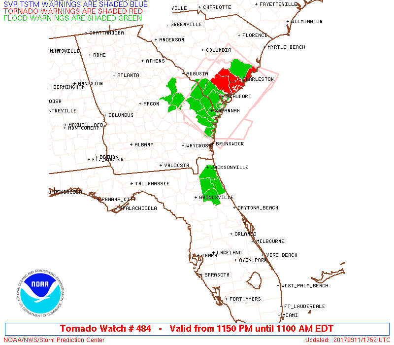
Watch 484 Status Report Messages:
STATUS REPORT #1 ON WW 484

VALID 111430Z - 111500Z

SEVERE WEATHER THREAT CONTINUES RIGHT OF A LINE FROM 30 ESE SSI
TO 10 N SSI TO 5 S VDI.

WW 484 WILL BE ALLOWED TO EXPIRE AT 111500Z.

..JIRAK..09/11/17

ATTN...WFO...JAX...CHS...

&&

STATUS REPORT FOR WT 484

SEVERE WEATHER THREAT CONTINUES FOR THE FOLLOWING AREAS

GAC029-051-179-183-191-111500-

GA
.    GEORGIA COUNTIES INCLUDED ARE

BRYAN		     CHATHAM		 LIBERTY
LONG		     MCINTOSH
$$


SCC013-015-019-029-035-053-111500-

SC
.    SOUTH CAROLINA COUNTIES INCLUDED ARE

BEAUFORT	     BERKELEY		 CHARLESTON
COLLETON	     DORCHESTER 	 JASPER
$$


AMZ330-350-352-354-370-372-374-111500-

CW

.    ADJACENT COASTAL WATERS INCLUDED ARE

CHARLESTON HARBOR

COASTAL WATERS FROM SOUTH SANTEE RIVER TO EDISTO BEACH SC OUT 20
NM

COASTAL WATERS FROM EDISTO BEACH SC TO SAVANNAH GA OUT 20 NM

COASTAL WATERS FROM SAVANNAH GA TO ALTAMAHA SOUND GA OUT 20 NM
...INCLUDING GRAYS REEF NATIONAL MARINE SANCTUARY

WATERS FROM SOUTH SANTEE RIVER SC TO EDISTO BEACH SC EXTENDING
FROM 20 NM TO 40 NM

WATERS FROM EDISTO BEACH SC TO SAVANNAH GA EXTENDING FROM 20 NM
TO 40 NM

WATERS FROM SAVANNAH GA TO ALTAMAHA SOUND GA EXTENDING FROM 20 NM
TO 60 NM

$$
THE WATCH STATUS MESSAGE IS FOR GUIDANCE PURPOSES ONLY.  PLEASE
REFER TO WATCH COUNTY NOTIFICATION STATEMENTS FOR OFFICIAL
INFORMATION ON COUNTIES...INDEPENDENT CITIES AND MARINE ZONES
CLEARED FROM SEVERE THUNDERSTORM AND TORNADO WATCHES.
$$
Note:
Click for Complete Product Text.
Tornadoes
Probability of 2 or more tornadoes
|
Mod (40%)
|
Probability of 1 or more strong (F2-F5) tornadoes
|
Low (20%)
|
Wind
Probability of 10 or more severe wind events
|
Low (10%)
|
Probability of 1 or more wind events > 65 knots
|
Low (10%)
|
Hail
Probability of 10 or more severe hail events
|
Low (<5%)
|
Probability of 1 or more hailstones > 2 inches
|
Low (<5%)
|
Combined Severe Hail/Wind
Probability of 6 or more combined severe hail/wind events
|
Mod (30%)
|
For each watch, probabilities for particular events inside the watch
(listed above in each table) are determined by the issuing forecaster.
The "Low" category contains probability values ranging from less than 2%
to 20% (F2-F5 tornadoes), less than 5% to 20% (all other probabilities),
"Moderate" from 30% to 60%, and "High" from 70% to greater than 95%.
High values are bolded and lighter in color to provide awareness of
an increased threat for a particular event.


 @NWSSPC