 Note:
The expiration time in the watch graphic is amended if the watch is
replaced, cancelled or extended.
Note:
Note:
The expiration time in the watch graphic is amended if the watch is
replaced, cancelled or extended.
Note: Click for
Watch Status Reports.
SEL4
URGENT - IMMEDIATE BROADCAST REQUESTED
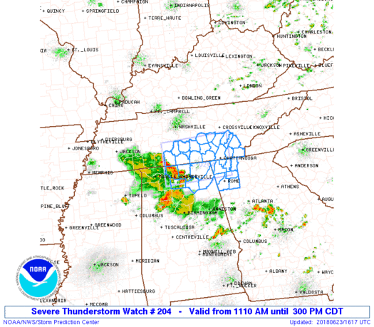
Severe Thunderstorm Watch Number 204
NWS Storm Prediction Center Norman OK
1110 AM CDT Sat Jun 23 2018
The NWS Storm Prediction Center has issued a
* Severe Thunderstorm Watch for portions of
Northeast Alabama
Northwest Georgia
Southern middle and southeast Tennessee
* Effective this Saturday morning and afternoon from 1110 AM
until 300 PM CDT.
* Primary threats include...
Scattered damaging wind gusts to 70 mph possible
SUMMARY...An organized storm cluster has been persistent this
morning moving along the Alabama-Tennessee border, and may persist
into the afternoon. A few damaging outflow gusts will be the main
threat for the next few hours.
The severe thunderstorm watch area is approximately along and 45
statute miles north and south of a line from 40 miles northwest of
Huntsville AL to 20 miles east northeast of Chattanooga TN. For a
complete depiction of the watch see the associated watch outline
update (WOUS64 KWNS WOU4).
PRECAUTIONARY/PREPAREDNESS ACTIONS...
REMEMBER...A Severe Thunderstorm Watch means conditions are
favorable for severe thunderstorms in and close to the watch area.
Persons in these areas should be on the lookout for threatening
weather conditions and listen for later statements and possible
warnings. Severe thunderstorms can and occasionally do produce
tornadoes.
&&
AVIATION...A few severe thunderstorms with hail surface and aloft to
1 inch. Extreme turbulence and surface wind gusts to 60 knots. A few
cumulonimbi with maximum tops to 450. Mean storm motion vector
26045.
...Thompson

   SEL4

   URGENT - IMMEDIATE BROADCAST REQUESTED
   Severe Thunderstorm Watch Number 204
   NWS Storm Prediction Center Norman OK
   1110 AM CDT Sat Jun 23 2018

   The NWS Storm Prediction Center has issued a

   * Severe Thunderstorm Watch for portions of
     Northeast Alabama
     Northwest Georgia
     Southern middle and southeast Tennessee

   * Effective this Saturday morning and afternoon from 1110 AM
     until 300 PM CDT.

   * Primary threats include...
     Scattered damaging wind gusts to 70 mph possible

   SUMMARY...An organized storm cluster has been persistent this
   morning moving along the Alabama-Tennessee border, and may persist
   into the afternoon.  A few damaging outflow gusts will be the main
   threat for the next few hours.

   The severe thunderstorm watch area is approximately along and 45
   statute miles north and south of a line from 40 miles northwest of
   Huntsville AL to 20 miles east northeast of Chattanooga TN. For a
   complete depiction of the watch see the associated watch outline
   update (WOUS64 KWNS WOU4).

   PRECAUTIONARY/PREPAREDNESS ACTIONS...

   REMEMBER...A Severe Thunderstorm Watch means conditions are
   favorable for severe thunderstorms in and close to the watch area.
   Persons in these areas should be on the lookout for threatening
   weather conditions and listen for later statements and possible
   warnings. Severe thunderstorms can and occasionally do produce
   tornadoes.

   &&

   AVIATION...A few severe thunderstorms with hail surface and aloft to
   1 inch. Extreme turbulence and surface wind gusts to 60 knots. A few
   cumulonimbi with maximum tops to 450. Mean storm motion vector
   26045.

   ...Thompson
 Note:
The Aviation Watch (SAW) product is an approximation to the watch area.
The actual watch is depicted by the shaded areas.
Note:
The Aviation Watch (SAW) product is an approximation to the watch area.
The actual watch is depicted by the shaded areas.
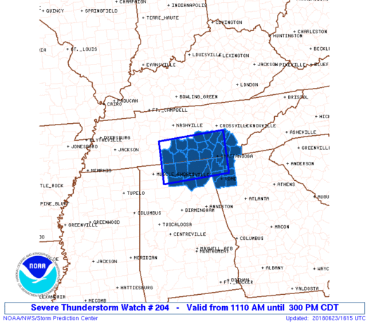
   SAW4
   WW 204 SEVERE TSTM AL GA TN 231610Z - 232000Z
   AXIS..45 STATUTE MILES NORTH AND SOUTH OF LINE..
   40NW HSV/HUNTSVILLE AL/ - 20ENE CHA/CHATTANOOGA TN/
   ..AVIATION COORDS.. 40NM N/S /24NNE MSL - 17NE GQO/
   HAIL SURFACE AND ALOFT..1 INCH. WIND GUSTS..60 KNOTS.
   MAX TOPS TO 450. MEAN STORM MOTION VECTOR 26045.

   LAT...LON 35708727 35798487 34498487 34408727

   THIS IS AN APPROXIMATION TO THE WATCH AREA.  FOR A
   COMPLETE DEPICTION OF THE WATCH SEE WOUS64 KWNS
   FOR WOU4.
Watch 204 Status Report Messages:
STATUS REPORT #5 ON WW 204

VALID 231900Z - 232000Z

SEVERE WEATHER THREAT CONTINUES RIGHT OF A LINE FROM 30 NE CHA TO
20 SW CSV.

WW 204 WILL BE ALLOWED TO EXPIRE AT 232000Z.

..SMITH..06/23/18

ATTN...WFO...HUN...FFC...OHX...MRX...

&&

STATUS REPORT FOR WS 204

SEVERE WEATHER THREAT CONTINUES FOR THE FOLLOWING AREAS

TNC007-107-121-139-143-232000-

TN
.    TENNESSEE COUNTIES INCLUDED ARE

BLEDSOE 	     MCMINN		 MEIGS
POLK		     RHEA
$$


THE WATCH STATUS MESSAGE IS FOR GUIDANCE PURPOSES ONLY.  PLEASE
REFER TO WATCH COUNTY NOTIFICATION STATEMENTS FOR OFFICIAL
INFORMATION ON COUNTIES...INDEPENDENT CITIES AND MARINE ZONES
CLEARED FROM SEVERE THUNDERSTORM AND TORNADO WATCHES.
$$

STATUS REPORT #4 ON WW 204

VALID 231825Z - 231940Z

SEVERE WEATHER THREAT CONTINUES RIGHT OF A LINE FROM 15 NE RMG TO
35 WSW CSV.

..SMITH..06/23/18

ATTN...WFO...HUN...FFC...OHX...MRX...

&&

STATUS REPORT FOR WS 204

SEVERE WEATHER THREAT CONTINUES FOR THE FOLLOWING AREAS

GAC047-129-213-313-231940-

GA
.    GEORGIA COUNTIES INCLUDED ARE

CATOOSA 	     GORDON		 MURRAY
WHITFIELD
$$


TNC007-011-065-107-121-139-143-153-231940-

TN
.    TENNESSEE COUNTIES INCLUDED ARE

BLEDSOE 	     BRADLEY		 HAMILTON
MCMINN		     MEIGS		 POLK
RHEA		     SEQUATCHIE
$$


THE WATCH STATUS MESSAGE IS FOR GUIDANCE PURPOSES ONLY.  PLEASE
REFER TO WATCH COUNTY NOTIFICATION STATEMENTS FOR OFFICIAL
INFORMATION ON COUNTIES...INDEPENDENT CITIES AND MARINE ZONES
CLEARED FROM SEVERE THUNDERSTORM AND TORNADO WATCHES.
$$

STATUS REPORT #3 ON WW 204

VALID 231820Z - 231940Z

SEVERE WEATHER THREAT CONTINUES RIGHT OF A LINE FROM 20 NE RMG TO
35 WSW CSV.

..SMITH..06/23/18

ATTN...WFO...HUN...FFC...OHX...MRX...

&&

STATUS REPORT FOR WS 204

SEVERE WEATHER THREAT CONTINUES FOR THE FOLLOWING AREAS

GAC015-047-129-213-313-231940-

GA
.    GEORGIA COUNTIES INCLUDED ARE

BARTOW		     CATOOSA		 GORDON
MURRAY		     WHITFIELD
$$


TNC007-011-065-107-115-121-139-143-153-175-231940-

TN
.    TENNESSEE COUNTIES INCLUDED ARE

BLEDSOE 	     BRADLEY		 HAMILTON
MCMINN		     MARION		 MEIGS
POLK		     RHEA		 SEQUATCHIE
VAN BUREN
$$


THE WATCH STATUS MESSAGE IS FOR GUIDANCE PURPOSES ONLY.  PLEASE
REFER TO WATCH COUNTY NOTIFICATION STATEMENTS FOR OFFICIAL
INFORMATION ON COUNTIES...INDEPENDENT CITIES AND MARINE ZONES
CLEARED FROM SEVERE THUNDERSTORM AND TORNADO WATCHES.
$$

STATUS REPORT #2 ON WW 204

VALID 231755Z - 231840Z

SEVERE WEATHER THREAT CONTINUES RIGHT OF A LINE FROM 15 NW RMG TO
40 WSW CSV.

..SMITH..06/23/18

ATTN...WFO...HUN...FFC...OHX...MRX...

&&

STATUS REPORT FOR WS 204

SEVERE WEATHER THREAT CONTINUES FOR THE FOLLOWING AREAS

GAC015-047-055-083-115-129-213-295-313-231840-

GA
.    GEORGIA COUNTIES INCLUDED ARE

BARTOW		     CATOOSA		 CHATTOOGA
DADE		     FLOYD		 GORDON
MURRAY		     WALKER		 WHITFIELD
$$


TNC007-011-061-065-107-115-121-139-143-153-175-177-231840-

TN
.    TENNESSEE COUNTIES INCLUDED ARE

BLEDSOE 	     BRADLEY		 GRUNDY
HAMILTON	     MCMINN		 MARION
MEIGS		     POLK		 RHEA
SEQUATCHIE	     VAN BUREN		 WARREN
$$


THE WATCH STATUS MESSAGE IS FOR GUIDANCE PURPOSES ONLY.  PLEASE
REFER TO WATCH COUNTY NOTIFICATION STATEMENTS FOR OFFICIAL
INFORMATION ON COUNTIES...INDEPENDENT CITIES AND MARINE ZONES
CLEARED FROM SEVERE THUNDERSTORM AND TORNADO WATCHES.
$$

STATUS REPORT #1 ON WW 204

VALID 231720Z - 231840Z

SEVERE WEATHER THREAT CONTINUES RIGHT OF A LINE FROM 35 NNE GAD
TO 30 SSE BNA.

..SMITH..06/23/18

ATTN...WFO...HUN...FFC...OHX...MRX...

&&

STATUS REPORT FOR WS 204

SEVERE WEATHER THREAT CONTINUES FOR THE FOLLOWING AREAS

ALC049-071-231840-

AL
.    ALABAMA COUNTIES INCLUDED ARE

DEKALB		     JACKSON
$$


GAC015-047-055-083-115-129-213-295-313-231840-

GA
.    GEORGIA COUNTIES INCLUDED ARE

BARTOW		     CATOOSA		 CHATTOOGA
DADE		     FLOYD		 GORDON
MURRAY		     WALKER		 WHITFIELD
$$


TNC003-007-011-031-051-061-065-107-115-121-127-139-143-153-175-
177-231840-

TN
.    TENNESSEE COUNTIES INCLUDED ARE

BEDFORD 	     BLEDSOE		 BRADLEY
COFFEE		     FRANKLIN		 GRUNDY
HAMILTON	     MCMINN		 MARION
MEIGS		     MOORE		 POLK
RHEA		     SEQUATCHIE 	 VAN BUREN
WARREN
$$


THE WATCH STATUS MESSAGE IS FOR GUIDANCE PURPOSES ONLY.  PLEASE
REFER TO WATCH COUNTY NOTIFICATION STATEMENTS FOR OFFICIAL
INFORMATION ON COUNTIES...INDEPENDENT CITIES AND MARINE ZONES
CLEARED FROM SEVERE THUNDERSTORM AND TORNADO WATCHES.
$$
Note:
Click for Complete Product Text.
Tornadoes
Probability of 2 or more tornadoes
|
Low (<5%)
|
Probability of 1 or more strong (F2-F5) tornadoes
|
Low (<2%)
|
Wind
Probability of 10 or more severe wind events
|
Mod (40%)
|
Probability of 1 or more wind events > 65 knots
|
Low (20%)
|
Hail
Probability of 10 or more severe hail events
|
Low (<5%)
|
Probability of 1 or more hailstones > 2 inches
|
Low (<5%)
|
Combined Severe Hail/Wind
Probability of 6 or more combined severe hail/wind events
|
Mod (50%)
|
For each watch, probabilities for particular events inside the watch
(listed above in each table) are determined by the issuing forecaster.
The "Low" category contains probability values ranging from less than 2%
to 20% (F2-F5 tornadoes), less than 5% to 20% (all other probabilities),
"Moderate" from 30% to 60%, and "High" from 70% to greater than 95%.
High values are bolded and lighter in color to provide awareness of
an increased threat for a particular event.


 @NWSSPC


