 Note:
The expiration time in the watch graphic is amended if the watch is
replaced, cancelled or extended.
Note:
Note:
The expiration time in the watch graphic is amended if the watch is
replaced, cancelled or extended.
Note: Click for
Watch Status Reports.
SEL3
URGENT - IMMEDIATE BROADCAST REQUESTED
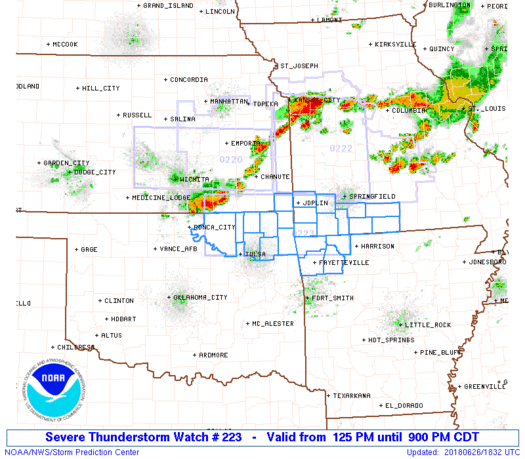
Severe Thunderstorm Watch Number 223
NWS Storm Prediction Center Norman OK
125 PM CDT Tue Jun 26 2018
The NWS Storm Prediction Center has issued a
* Severe Thunderstorm Watch for portions of
Northwestern Arkansas
Extreme southeastern Kansas
Southwestern Missouri
Northeastern Oklahoma
* Effective this Tuesday afternoon and evening from 125 PM until
900 PM CDT.
* Primary threats include...
Scattered large hail likely with isolated very large hail events
to 2 inches in diameter possible
Scattered damaging wind gusts to 70 mph likely
SUMMARY...A small cluster of storms has recently intensified over
southern Kansas, and this trend should continue through the
afternoon as the storms move east-southeastward into northeastern
Oklahoma. A very unstable environment is present in advance of the
storms, which will support a threat for damaging winds and large
hail.
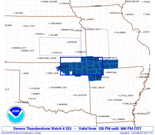
The severe thunderstorm watch area is approximately along and 40
statute miles north and south of a line from 40 miles west of
Bartlesville OK to 35 miles east southeast of Monett MO. For a
complete depiction of the watch see the associated watch outline
update (WOUS64 KWNS WOU3).
PRECAUTIONARY/PREPAREDNESS ACTIONS...
REMEMBER...A Severe Thunderstorm Watch means conditions are
favorable for severe thunderstorms in and close to the watch area.
Persons in these areas should be on the lookout for threatening
weather conditions and listen for later statements and possible
warnings. Severe thunderstorms can and occasionally do produce
tornadoes.
&&
OTHER WATCH INFORMATION...CONTINUE...WW 220...WW 221...WW 222...
AVIATION...A few severe thunderstorms with hail surface and aloft to
2 inches. Extreme turbulence and surface wind gusts to 60 knots. A
few cumulonimbi with maximum tops to 600. Mean storm motion vector
29030.
...Thompson
   SEL3

   URGENT - IMMEDIATE BROADCAST REQUESTED
   Severe Thunderstorm Watch Number 223
   NWS Storm Prediction Center Norman OK
   125 PM CDT Tue Jun 26 2018

   The NWS Storm Prediction Center has issued a

   * Severe Thunderstorm Watch for portions of
     Northwestern Arkansas
     Extreme southeastern Kansas
     Southwestern Missouri
     Northeastern Oklahoma

   * Effective this Tuesday afternoon and evening from 125 PM until
     900 PM CDT.

   * Primary threats include...
     Scattered large hail likely with isolated very large hail events
       to 2 inches in diameter possible
     Scattered damaging wind gusts to 70 mph likely

   SUMMARY...A small cluster of storms has recently intensified over
   southern Kansas, and this trend should continue through the
   afternoon as the storms move east-southeastward into northeastern
   Oklahoma.  A very unstable environment is present in advance of the
   storms, which will support a threat for damaging winds and large
   hail.

   The severe thunderstorm watch area is approximately along and 40
   statute miles north and south of a line from 40 miles west of
   Bartlesville OK to 35 miles east southeast of Monett MO. For a
   complete depiction of the watch see the associated watch outline
   update (WOUS64 KWNS WOU3).

   PRECAUTIONARY/PREPAREDNESS ACTIONS...

   REMEMBER...A Severe Thunderstorm Watch means conditions are
   favorable for severe thunderstorms in and close to the watch area.
   Persons in these areas should be on the lookout for threatening
   weather conditions and listen for later statements and possible
   warnings. Severe thunderstorms can and occasionally do produce
   tornadoes.

   &&

   OTHER WATCH INFORMATION...CONTINUE...WW 220...WW 221...WW 222...

   AVIATION...A few severe thunderstorms with hail surface and aloft to
   2 inches. Extreme turbulence and surface wind gusts to 60 knots. A
   few cumulonimbi with maximum tops to 600. Mean storm motion vector
   29030.

   ...Thompson
 Note:
The Aviation Watch (SAW) product is an approximation to the watch area.
The actual watch is depicted by the shaded areas.
Note:
The Aviation Watch (SAW) product is an approximation to the watch area.
The actual watch is depicted by the shaded areas.
   SAW3
   WW 223 SEVERE TSTM AR KS MO OK 261825Z - 270200Z
   AXIS..40 STATUTE MILES NORTH AND SOUTH OF LINE..
   40W BVO/BARTLESVILLE OK/ - 35ESE UMN/MONETT MO/
   ..AVIATION COORDS.. 35NM N/S /57NW TUL - 41S SGF/
   HAIL SURFACE AND ALOFT..2 INCHES. WIND GUSTS..60 KNOTS.
   MAX TOPS TO 600. MEAN STORM MOTION VECTOR 29030.

   LAT...LON 37349673 37259331 36119331 36189673

   THIS IS AN APPROXIMATION TO THE WATCH AREA.  FOR A
   COMPLETE DEPICTION OF THE WATCH SEE WOUS64 KWNS
   FOR WOU3.
Watch 223 Status Report Messages:
STATUS REPORT #3 ON WW 223

VALID 262355Z - 270040Z

SEVERE WEATHER THREAT CONTINUES RIGHT OF A LINE FROM 20 WSW HRO
TO 10 WSW HRO.

FOR ADDITIONAL INFORMATION SEE MESOSCALE DISCUSSION 897.

..PETERS..06/26/18

ATTN...WFO...TSA...SGF...

&&

STATUS REPORT FOR WS 223

SEVERE WEATHER THREAT CONTINUES FOR THE FOLLOWING AREAS

ARC015-087-270040-

AR
.    ARKANSAS COUNTIES INCLUDED ARE

CARROLL 	     MADISON
$$


MOC067-153-270040-

MO
.    MISSOURI COUNTIES INCLUDED ARE

DOUGLAS 	     OZARK
$$


THE WATCH STATUS MESSAGE IS FOR GUIDANCE PURPOSES ONLY.  PLEASE
REFER TO WATCH COUNTY NOTIFICATION STATEMENTS FOR OFFICIAL
INFORMATION ON COUNTIES...INDEPENDENT CITIES AND MARINE ZONES
CLEARED FROM SEVERE THUNDERSTORM AND TORNADO WATCHES.
$$

STATUS REPORT #2 ON WW 223

VALID 262240Z - 262340Z

SEVERE WEATHER THREAT CONTINUES RIGHT OF A LINE FROM 30 S GMJ TO
25 S UMN TO 20 ESE SGF.

..EDWARDS..06/26/18

ATTN...WFO...TSA...SGF...

&&

STATUS REPORT FOR WS 223

SEVERE WEATHER THREAT CONTINUES FOR THE FOLLOWING AREAS

ARC007-015-087-143-262340-

AR
.    ARKANSAS COUNTIES INCLUDED ARE

BENTON		     CARROLL		 MADISON
WASHINGTON
$$


MOC009-043-067-153-209-213-262340-

MO
.    MISSOURI COUNTIES INCLUDED ARE

BARRY		     CHRISTIAN		 DOUGLAS
OZARK		     STONE		 TANEY
$$


THE WATCH STATUS MESSAGE IS FOR GUIDANCE PURPOSES ONLY.  PLEASE
REFER TO WATCH COUNTY NOTIFICATION STATEMENTS FOR OFFICIAL
INFORMATION ON COUNTIES...INDEPENDENT CITIES AND MARINE ZONES
CLEARED FROM SEVERE THUNDERSTORM AND TORNADO WATCHES.
$$

STATUS REPORT #1 ON WW 223

VALID 262200Z - 262340Z

SEVERE WEATHER THREAT CONTINUES RIGHT OF A LINE FROM 30 E TUL TO
20 SW GMJ TO 15 E GMJ TO 15 WNW UMN TO 10 NNE UMN TO 10 WNW SGF.

..PETERS..06/26/18

ATTN...WFO...TSA...SGF...

&&

STATUS REPORT FOR WS 223

SEVERE WEATHER THREAT CONTINUES FOR THE FOLLOWING AREAS

ARC007-015-087-143-262340-

AR
.    ARKANSAS COUNTIES INCLUDED ARE

BENTON		     CARROLL		 MADISON
WASHINGTON
$$


MOC009-043-067-109-119-145-153-209-213-262340-

MO
.    MISSOURI COUNTIES INCLUDED ARE

BARRY		     CHRISTIAN		 DOUGLAS
LAWRENCE	     MCDONALD		 NEWTON
OZARK		     STONE		 TANEY
$$


OKC041-097-262340-

OK
.    OKLAHOMA COUNTIES INCLUDED ARE

DELAWARE	     MAYES
$$


THE WATCH STATUS MESSAGE IS FOR GUIDANCE PURPOSES ONLY.  PLEASE
REFER TO WATCH COUNTY NOTIFICATION STATEMENTS FOR OFFICIAL
INFORMATION ON COUNTIES...INDEPENDENT CITIES AND MARINE ZONES
CLEARED FROM SEVERE THUNDERSTORM AND TORNADO WATCHES.
$$
Note:
Click for Complete Product Text.
Tornadoes
Probability of 2 or more tornadoes
|
Low (10%)
|
Probability of 1 or more strong (F2-F5) tornadoes
|
Low (<2%)
|
Wind
Probability of 10 or more severe wind events
|
Mod (60%)
|
Probability of 1 or more wind events > 65 knots
|
Low (20%)
|
Hail
Probability of 10 or more severe hail events
|
Mod (60%)
|
Probability of 1 or more hailstones > 2 inches
|
Mod (30%)
|
Combined Severe Hail/Wind
Probability of 6 or more combined severe hail/wind events
|
High (>95%)
|
For each watch, probabilities for particular events inside the watch
(listed above in each table) are determined by the issuing forecaster.
The "Low" category contains probability values ranging from less than 2%
to 20% (F2-F5 tornadoes), less than 5% to 20% (all other probabilities),
"Moderate" from 30% to 60%, and "High" from 70% to greater than 95%.
High values are bolded and lighter in color to provide awareness of
an increased threat for a particular event.


 @NWSSPC


