|
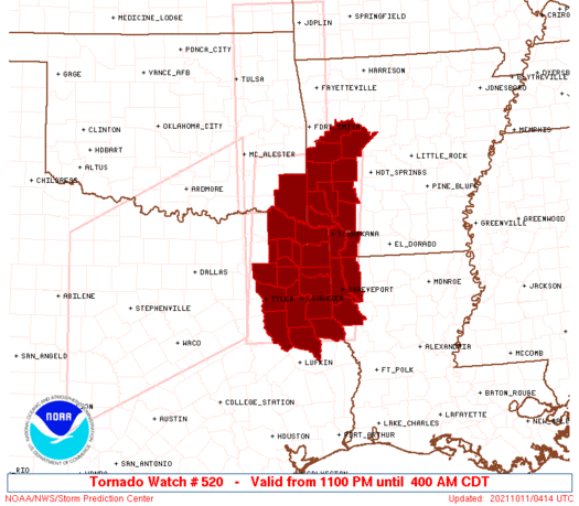
Initial List of Counties in SPC Tornado Watch 520 (WOU)
|
Back to Watch 520
|
 |
   WOUS64 KWNS 110403
   WOU0

   BULLETIN - IMMEDIATE BROADCAST REQUESTED
   TORNADO WATCH OUTLINE UPDATE FOR WT 520
   NWS STORM PREDICTION CENTER NORMAN OK
   1100 PM CDT SUN OCT 10 2021

   TORNADO WATCH 520 IS IN EFFECT UNTIL 400 AM CDT FOR THE
    FOLLOWING LOCATIONS

   ARC057-061-073-081-083-091-097-109-113-127-133-149-110900-
   /O.NEW.KWNS.TO.A.0520.211011T0400Z-211011T0900Z/

   AR
   .    ARKANSAS COUNTIES INCLUDED ARE

   HEMPSTEAD            HOWARD              LAFAYETTE
   LITTLE RIVER         LOGAN               MILLER
   MONTGOMERY           PIKE                POLK
   SCOTT                SEVIER              YELL


   LAC015-017-031-110900-
   /O.NEW.KWNS.TO.A.0520.211011T0400Z-211011T0900Z/

   LA
   .    LOUISIANA PARISHES INCLUDED ARE

   BOSSIER              CADDO               DE SOTO


   OKC089-110900-
   /O.NEW.KWNS.TO.A.0520.211011T0400Z-211011T0900Z/

   OK
   .    OKLAHOMA COUNTIES INCLUDED ARE

   MCCURTAIN


   TXC037-063-067-073-159-183-203-315-343-347-365-387-401-419-423-
   449-459-499-110900-
   /O.NEW.KWNS.TO.A.0520.211011T0400Z-211011T0900Z/

   TX
   .    TEXAS COUNTIES INCLUDED ARE

   BOWIE                CAMP                CASS
   CHEROKEE             FRANKLIN            GREGG
   HARRISON             MARION              MORRIS
   NACOGDOCHES          PANOLA              RED RIVER
   RUSK                 SHELBY              SMITH
   TITUS                UPSHUR              WOOD


   ATTN...WFO...SHV...LZK...
|
| Aviation Watch (SAW) for WW520 |
|---|
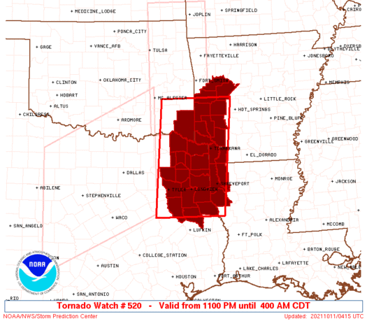 |
| Note:
The Aviation Watch (SAW) product is an approximation to the watch area.
The actual watch is depicted by the shaded areas. |
   SAW0
   WW 520 TORNADO AR LA OK TX 110400Z - 110900Z
   AXIS..65 STATUTE MILES EAST AND WEST OF LINE..
   55N DEQ/DE QUEEN AR/ - 55S GGG/LONGVIEW TX/
   ..AVIATION COORDS.. 55NM E/W /33SSW FSM - 25N LFK/
   HAIL SURFACE AND ALOFT..1.5 INCHES. WIND GUSTS..65 KNOTS.
   MAX TOPS TO 500. MEAN STORM MOTION VECTOR 27040.

   LAT...LON 34849325 31589362 31589582 34849555

   THIS IS AN APPROXIMATION TO THE WATCH AREA.  FOR A
   COMPLETE DEPICTION OF THE WATCH SEE WOUS64 KWNS
   FOR WOU0.
|
|


 @NWSSPC
