Note:
The expiration time in the watch graphic is amended if the watch is
replaced, cancelled or extended.
Note:
Note:
The expiration time in the watch graphic is amended if the watch is
replaced, cancelled or extended.
Note: Click for
Watch Status Reports.
SEL0
URGENT - IMMEDIATE BROADCAST REQUESTED
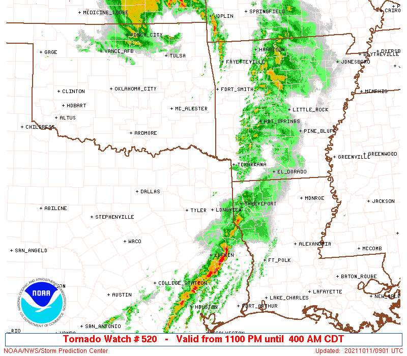
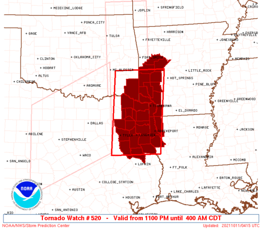
Tornado Watch Number 520
NWS Storm Prediction Center Norman OK
1100 PM CDT Sun Oct 10 2021
The NWS Storm Prediction Center has issued a
* Tornado Watch for portions of
Western Arkansas
Northwest Louisiana
Southeast Oklahoma
Northeast Texas
* Effective this Sunday night and Monday morning from 1100 PM
until 400 AM CDT.
* Primary threats include...
A few tornadoes possible
Scattered damaging winds likely with isolated significant gusts
to 75 mph possible
Isolated large hail events to 1.5 inches in diameter possible
SUMMARY...Line of storms with embedded bowing segments and
mesovortices will continue east through northeast TX and into the
Arklatex region tonight. Damaging wind and a few tornadoes are the
main threats.
The tornado watch area is approximately along and 65 statute miles
east and west of a line from 55 miles north of De Queen AR to 55
miles south of Longview TX. For a complete depiction of the watch
see the associated watch outline update (WOUS64 KWNS WOU0).
PRECAUTIONARY/PREPAREDNESS ACTIONS...
REMEMBER...A Tornado Watch means conditions are favorable for
tornadoes and severe thunderstorms in and close to the watch
area. Persons in these areas should be on the lookout for
threatening weather conditions and listen for later statements
and possible warnings.
&&
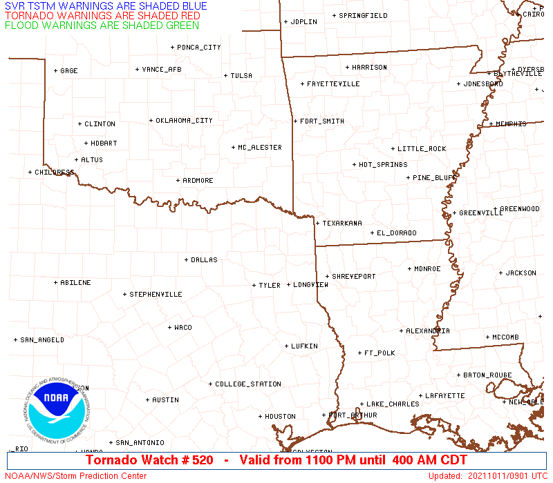
OTHER WATCH INFORMATION...CONTINUE...WW 518...WW 519...
AVIATION...Tornadoes and a few severe thunderstorms with hail
surface and aloft to 1.5 inches. Extreme turbulence and surface wind
gusts to 65 knots. A few cumulonimbi with maximum tops to 500. Mean
storm motion vector 27040.
...Dial
 Note:
The Aviation Watch (SAW) product is an approximation to the watch area.
The actual watch is depicted by the shaded areas.
Note:
The Aviation Watch (SAW) product is an approximation to the watch area.
The actual watch is depicted by the shaded areas.
   SAW0
   WW 520 TORNADO AR LA OK TX 110400Z - 110900Z
   AXIS..65 STATUTE MILES EAST AND WEST OF LINE..
   55N DEQ/DE QUEEN AR/ - 55S GGG/LONGVIEW TX/
   ..AVIATION COORDS.. 55NM E/W /33SSW FSM - 25N LFK/
   HAIL SURFACE AND ALOFT..1.5 INCHES. WIND GUSTS..65 KNOTS.
   MAX TOPS TO 500. MEAN STORM MOTION VECTOR 27040.

   LAT...LON 34849325 31589362 31589582 34849555

   THIS IS AN APPROXIMATION TO THE WATCH AREA.  FOR A
   COMPLETE DEPICTION OF THE WATCH SEE WOUS64 KWNS
   FOR WOU0.
Watch 520 Status Report Messages:
STATUS REPORT #4 ON WW 520
VALID 110835Z - 110900Z
SEVERE WEATHER THREAT CONTINUES RIGHT OF A LINE FROM 10 N LFK TO
15 W SHV TO 5 N TXK TO 40 NNE TXK TO 35 S HOT.
WW 520 WILL BE ALLOWED TO EXPIRE AT 110900Z.
..GLEASON..10/11/21
ATTN...WFO...SHV...LZK...
&&
STATUS REPORT FOR WT 520
SEVERE WEATHER THREAT CONTINUES FOR THE FOLLOWING AREAS
ARC057-073-091-110900-
AR
. ARKANSAS COUNTIES INCLUDED ARE
HEMPSTEAD LAFAYETTE MILLER
$$
LAC015-017-031-110900-
LA
. LOUISIANA PARISHES INCLUDED ARE
BOSSIER CADDO DE SOTO
$$
TXC365-419-110900-
TX
. TEXAS COUNTIES INCLUDED ARE
PANOLA SHELBY
$$
THE WATCH STATUS MESSAGE IS FOR GUIDANCE PURPOSES ONLY. PLEASE
REFER TO WATCH COUNTY NOTIFICATION STATEMENTS FOR OFFICIAL
INFORMATION ON COUNTIES...INDEPENDENT CITIES AND MARINE ZONES
CLEARED FROM SEVERE THUNDERSTORM AND TORNADO WATCHES.
$$
STATUS REPORT #3 ON WW 520
VALID 110725Z - 110840Z
SEVERE WEATHER THREAT CONTINUES RIGHT OF A LINE FROM 35 NW LFK TO
15 SSE GGG TO 35 SW TXK TO 35 W HOT TO 35 WNW RUE.
..GLEASON..10/11/21
ATTN...WFO...SHV...LZK...
&&
STATUS REPORT FOR WT 520
SEVERE WEATHER THREAT CONTINUES FOR THE FOLLOWING AREAS
ARC057-061-073-081-083-091-097-109-149-110840-
AR
. ARKANSAS COUNTIES INCLUDED ARE
HEMPSTEAD HOWARD LAFAYETTE
LITTLE RIVER LOGAN MILLER
MONTGOMERY PIKE YELL
$$
LAC015-017-031-110840-
LA
. LOUISIANA PARISHES INCLUDED ARE
BOSSIER CADDO DE SOTO
$$
TXC037-067-073-203-315-347-365-401-419-110840-
TX
. TEXAS COUNTIES INCLUDED ARE
BOWIE CASS CHEROKEE
HARRISON MARION NACOGDOCHES
PANOLA RUSK SHELBY
$$
THE WATCH STATUS MESSAGE IS FOR GUIDANCE PURPOSES ONLY. PLEASE
REFER TO WATCH COUNTY NOTIFICATION STATEMENTS FOR OFFICIAL
INFORMATION ON COUNTIES...INDEPENDENT CITIES AND MARINE ZONES
CLEARED FROM SEVERE THUNDERSTORM AND TORNADO WATCHES.
$$
STATUS REPORT #2 ON WW 520
VALID 110635Z - 110740Z
SEVERE WEATHER THREAT CONTINUES RIGHT OF A LINE FROM 55 N UTS TO
35 SSE TYR TO 35 NNW GGG TO 40 SSW DEQ TO 30 NE DEQ TO 15 SE FSM.
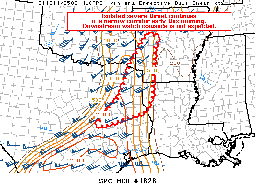
FOR ADDITIONAL INFORMATION SEE MESOSCALE DISCUSSION 1828
..GLEASON..10/11/21
ATTN...WFO...SHV...LZK...
&&
STATUS REPORT FOR WT 520
SEVERE WEATHER THREAT CONTINUES FOR THE FOLLOWING AREAS
ARC057-061-073-081-083-091-097-109-113-127-133-149-110740-
AR
. ARKANSAS COUNTIES INCLUDED ARE
HEMPSTEAD HOWARD LAFAYETTE
LITTLE RIVER LOGAN MILLER
MONTGOMERY PIKE POLK
SCOTT SEVIER YELL
$$
LAC015-017-031-110740-
LA
. LOUISIANA PARISHES INCLUDED ARE
BOSSIER CADDO DE SOTO
$$
TXC037-067-073-183-203-315-343-347-365-401-419-423-459-110740-
TX
. TEXAS COUNTIES INCLUDED ARE
BOWIE CASS CHEROKEE
GREGG HARRISON MARION
MORRIS NACOGDOCHES PANOLA
RUSK SHELBY SMITH
UPSHUR
$$
THE WATCH STATUS MESSAGE IS FOR GUIDANCE PURPOSES ONLY. PLEASE
REFER TO WATCH COUNTY NOTIFICATION STATEMENTS FOR OFFICIAL
INFORMATION ON COUNTIES...INDEPENDENT CITIES AND MARINE ZONES
CLEARED FROM SEVERE THUNDERSTORM AND TORNADO WATCHES.
$$
STATUS REPORT #1 ON WW 520
VALID 110525Z - 110640Z
SEVERE WEATHER THREAT CONTINUES RIGHT OF A LINE FROM 25 W TYR TO
15 WNW TYR TO 25 SSE PRX TO 10 ESE RKR.
..GLEASON..10/11/21
ATTN...WFO...SHV...LZK...
&&
STATUS REPORT FOR WT 520
SEVERE WEATHER THREAT CONTINUES FOR THE FOLLOWING AREAS
ARC057-061-073-081-083-091-097-109-113-127-133-149-110640-
AR
. ARKANSAS COUNTIES INCLUDED ARE
HEMPSTEAD HOWARD LAFAYETTE
LITTLE RIVER LOGAN MILLER
MONTGOMERY PIKE POLK
SCOTT SEVIER YELL
$$
LAC015-017-031-110640-
LA
. LOUISIANA PARISHES INCLUDED ARE
BOSSIER CADDO DE SOTO
$$
OKC089-110640-
OK
. OKLAHOMA COUNTIES INCLUDED ARE
MCCURTAIN
$$
TXC037-063-067-073-159-183-203-315-343-347-365-387-401-419-423-
449-459-499-110640-
TX
. TEXAS COUNTIES INCLUDED ARE
BOWIE CAMP CASS
CHEROKEE FRANKLIN GREGG
HARRISON MARION MORRIS
NACOGDOCHES PANOLA RED RIVER
RUSK SHELBY SMITH
TITUS UPSHUR WOOD
$$
THE WATCH STATUS MESSAGE IS FOR GUIDANCE PURPOSES ONLY. PLEASE
REFER TO WATCH COUNTY NOTIFICATION STATEMENTS FOR OFFICIAL
INFORMATION ON COUNTIES...INDEPENDENT CITIES AND MARINE ZONES
CLEARED FROM SEVERE THUNDERSTORM AND TORNADO WATCHES.
$$
Note:
Click for Complete Product Text.
Tornadoes
Probability of 2 or more tornadoes
|
Mod (50%)
|
Probability of 1 or more strong (EF2-EF5) tornadoes
|
Low (20%)
|
Wind
Probability of 10 or more severe wind events
|
Mod (60%)
|
Probability of 1 or more wind events > 65 knots
|
Mod (30%)
|
Hail
Probability of 10 or more severe hail events
|
Mod (30%)
|
Probability of 1 or more hailstones > 2 inches
|
Low (20%)
|
Combined Severe Hail/Wind
Probability of 6 or more combined severe hail/wind events
|
High (80%)
|
For each watch, probabilities for particular events inside the watch
(listed above in each table) are determined by the issuing forecaster.
The "Low" category contains probability values ranging from less than 2%
to 20% (EF2-EF5 tornadoes), less than 5% to 20% (all other probabilities),
"Moderate" from 30% to 60%, and "High" from 70% to greater than 95%.
High values are bolded and lighter in color to provide awareness of
an increased threat for a particular event.


 @NWSSPC