Note:
The expiration time in the watch graphic is amended if the watch is
replaced, cancelled or extended.
Note:
Note:
The expiration time in the watch graphic is amended if the watch is
replaced, cancelled or extended.
Note: Click for
Watch Status Reports.
SEL0
URGENT - IMMEDIATE BROADCAST REQUESTED
Tornado Watch Number 30
NWS Storm Prediction Center Norman OK
1155 AM CDT Wed Mar 17 2021
The NWS Storm Prediction Center has issued a
* Tornado Watch for portions of
Southwest Louisiana
Far southeast Texas
Coastal Waters
* Effective this Wednesday morning and evening from 1155 AM until
600 PM CDT.
* Primary threats include...
A few tornadoes likely with a couple intense tornadoes possible
Scattered damaging winds and isolated significant gusts to 75
mph possible
Scattered large hail and isolated very large hail events to 2.5
inches in diameter possible
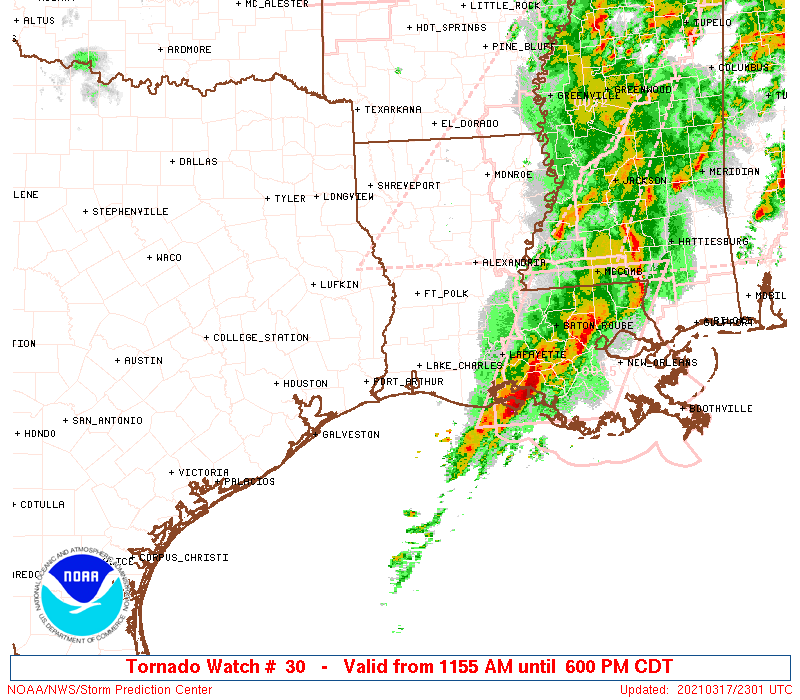
SUMMARY...A few discrete supercells should develop along and just
ahead of the cold front pushing east from southeast Texas. The
greatest tornado threat is expected towards central Louisiana during
the late afternoon.
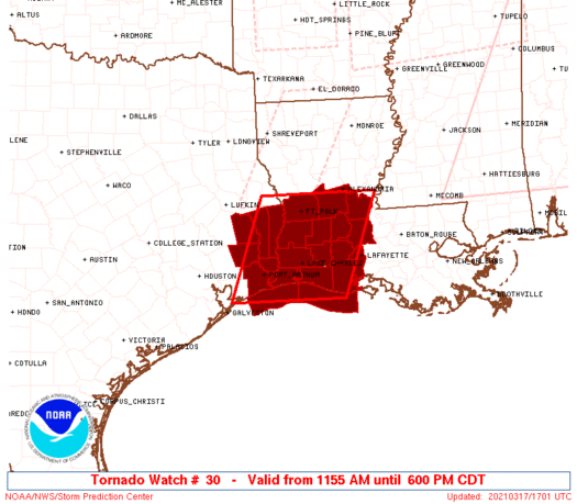
The tornado watch area is approximately along and 70 statute miles
east and west of a line from 30 miles northeast of Fort Polk LA to
50 miles south southwest of Lake Charles LA. For a complete
depiction of the watch see the associated watch outline update
(WOUS64 KWNS WOU0).
PRECAUTIONARY/PREPAREDNESS ACTIONS...
REMEMBER...A Tornado Watch means conditions are favorable for
tornadoes and severe thunderstorms in and close to the watch
area. Persons in these areas should be on the lookout for
threatening weather conditions and listen for later statements
and possible warnings.
&&
OTHER WATCH INFORMATION...CONTINUE...WW 26...WW 27...WW 28...WW
29...
AVIATION...Tornadoes and a few severe thunderstorms with hail
surface and aloft to 2.5 inches. Extreme turbulence and surface wind
gusts to 65 knots. A few cumulonimbi with maximum tops to 550. Mean
storm motion vector 24035.
...Grams
 Note:
The Aviation Watch (SAW) product is an approximation to the watch area.
The actual watch is depicted by the shaded areas.
Note:
The Aviation Watch (SAW) product is an approximation to the watch area.
The actual watch is depicted by the shaded areas.
   SAW0
   WW 30 TORNADO LA TX CW 171655Z - 172300Z
   AXIS..70 STATUTE MILES EAST AND WEST OF LINE..
   30NE POE/FORT POLK LA/ - 50SSW LCH/LAKE CHARLES LA/
   ..AVIATION COORDS.. 60NM E/W /17WNW AEX - 46SSW LCH/
   HAIL SURFACE AND ALOFT..2.5 INCHES. WIND GUSTS..65 KNOTS.
   MAX TOPS TO 550. MEAN STORM MOTION VECTOR 24035.

   LAT...LON 31359163 29469237 29469470 31359401

   THIS IS AN APPROXIMATION TO THE WATCH AREA.  FOR A
   COMPLETE DEPICTION OF THE WATCH SEE WOUS64 KWNS
   FOR WOU0.
Watch 30 Status Report Messages:
STATUS REPORT #4 ON WW 30

VALID 172230Z - 172300Z

SEVERE WEATHER THREAT CONTINUES RIGHT OF A LINE FROM 40 WSW 7R4
TO 30 NW 7R4 TO 40 NNW LFT TO 30 ENE ESF.

WW 30 WILL BE ALLOWED TO EXPIRE AT 172300Z.

..LYONS..03/17/21

ATTN...WFO...LCH...

&&

STATUS REPORT FOR WT 30

SEVERE WEATHER THREAT CONTINUES FOR THE FOLLOWING AREAS

LAC001-055-097-113-172300-

LA
.    LOUISIANA PARISHES INCLUDED ARE

ACADIA		     LAFAYETTE		 ST. LANDRY
VERMILION
$$


THE WATCH STATUS MESSAGE IS FOR GUIDANCE PURPOSES ONLY.  PLEASE
REFER TO WATCH COUNTY NOTIFICATION STATEMENTS FOR OFFICIAL
INFORMATION ON COUNTIES...INDEPENDENT CITIES AND MARINE ZONES
CLEARED FROM SEVERE THUNDERSTORM AND TORNADO WATCHES.
$$

STATUS REPORT #3 ON WW 30

VALID 172045Z - 172140Z

SEVERE WEATHER THREAT CONTINUES RIGHT OF A LINE FROM 45 SE BPT TO
5 SW LCH TO 20 SSE POE TO 30 SSE IER TO 20 NE IER.

..BENTLEY..03/17/21

ATTN...WFO...LCH...

&&

STATUS REPORT FOR WT 30

SEVERE WEATHER THREAT CONTINUES FOR THE FOLLOWING AREAS

LAC001-003-009-019-023-039-053-055-079-097-113-172140-

LA
.    LOUISIANA PARISHES INCLUDED ARE

ACADIA		     ALLEN		 AVOYELLES
CALCASIEU	     CAMERON		 EVANGELINE
JEFFERSON DAVIS      LAFAYETTE		 RAPIDES
ST. LANDRY	     VERMILION
$$


GMZ432-452-172140-

CW

.    ADJACENT COASTAL WATERS INCLUDED ARE

CALCASIEU LAKE

COASTAL WATERS FROM INTRACOASTAL CITY TO CAMERON LA OUT 20 NM

$$
THE WATCH STATUS MESSAGE IS FOR GUIDANCE PURPOSES ONLY.  PLEASE
REFER TO WATCH COUNTY NOTIFICATION STATEMENTS FOR OFFICIAL
INFORMATION ON COUNTIES...INDEPENDENT CITIES AND MARINE ZONES
CLEARED FROM SEVERE THUNDERSTORM AND TORNADO WATCHES.
$$

STATUS REPORT #2 ON WW 30

VALID 171930Z - 172040Z

SEVERE WEATHER THREAT CONTINUES RIGHT OF A LINE FROM 25 ESE GLS
TO 10 N BPT TO 45 NNE BPT TO 40 WSW POE TO 50 WNW POE.

..BENTLEY..03/17/21

ATTN...WFO...LCH...

&&

STATUS REPORT FOR WT 30

SEVERE WEATHER THREAT CONTINUES FOR THE FOLLOWING AREAS

LAC001-003-009-011-019-023-039-053-055-079-097-113-115-172040-

LA
.    LOUISIANA PARISHES INCLUDED ARE

ACADIA		     ALLEN		 AVOYELLES
BEAUREGARD	     CALCASIEU		 CAMERON
EVANGELINE	     JEFFERSON DAVIS	 LAFAYETTE
RAPIDES 	     ST. LANDRY 	 VERMILION
VERNON
$$


TXC245-351-361-172040-

TX
.    TEXAS COUNTIES INCLUDED ARE

JEFFERSON	     NEWTON		 ORANGE
$$


GMZ430-432-450-452-172040-

CW

.    ADJACENT COASTAL WATERS INCLUDED ARE

SABINE LAKE

CALCASIEU LAKE

COASTAL WATERS FROM CAMERON LA TO HIGH ISLAND TX OUT 20 NM

COASTAL WATERS FROM INTRACOASTAL CITY TO CAMERON LA OUT 20 NM

$$
THE WATCH STATUS MESSAGE IS FOR GUIDANCE PURPOSES ONLY.  PLEASE
REFER TO WATCH COUNTY NOTIFICATION STATEMENTS FOR OFFICIAL
INFORMATION ON COUNTIES...INDEPENDENT CITIES AND MARINE ZONES
CLEARED FROM SEVERE THUNDERSTORM AND TORNADO WATCHES.
$$

STATUS REPORT #1 ON WW 30

VALID 171740Z - 171840Z

THE SEVERE WEATHER THREAT CONTINUES ACROSS THE ENTIRE WATCH AREA.

..BENTLEY..03/17/21

ATTN...WFO...LCH...

&&

STATUS REPORT FOR WT 30

SEVERE WEATHER THREAT CONTINUES FOR THE FOLLOWING AREAS

LAC001-003-009-011-019-023-039-053-055-079-097-113-115-171840-

LA
.    LOUISIANA PARISHES INCLUDED ARE

ACADIA		     ALLEN		 AVOYELLES
BEAUREGARD	     CALCASIEU		 CAMERON
EVANGELINE	     JEFFERSON DAVIS	 LAFAYETTE
RAPIDES 	     ST. LANDRY 	 VERMILION
VERNON
$$


TXC199-241-245-351-361-457-171840-

TX
.    TEXAS COUNTIES INCLUDED ARE

HARDIN		     JASPER		 JEFFERSON
NEWTON		     ORANGE		 TYLER
$$


GMZ430-432-450-452-171840-

CW

.    ADJACENT COASTAL WATERS INCLUDED ARE

SABINE LAKE

CALCASIEU LAKE

COASTAL WATERS FROM CAMERON LA TO HIGH ISLAND TX OUT 20 NM

COASTAL WATERS FROM INTRACOASTAL CITY TO CAMERON LA OUT 20 NM

$$
THE WATCH STATUS MESSAGE IS FOR GUIDANCE PURPOSES ONLY.  PLEASE
REFER TO WATCH COUNTY NOTIFICATION STATEMENTS FOR OFFICIAL
INFORMATION ON COUNTIES...INDEPENDENT CITIES AND MARINE ZONES
CLEARED FROM SEVERE THUNDERSTORM AND TORNADO WATCHES.
$$
Note:
Click for Complete Product Text.
Tornadoes
Probability of 2 or more tornadoes
|
Mod (60%)
|
Probability of 1 or more strong (EF2-EF5) tornadoes
|
Mod (40%)
|
Wind
Probability of 10 or more severe wind events
|
Mod (40%)
|
Probability of 1 or more wind events > 65 knots
|
Mod (30%)
|
Hail
Probability of 10 or more severe hail events
|
Mod (40%)
|
Probability of 1 or more hailstones > 2 inches
|
Mod (40%)
|
Combined Severe Hail/Wind
Probability of 6 or more combined severe hail/wind events
|
High (70%)
|
For each watch, probabilities for particular events inside the watch
(listed above in each table) are determined by the issuing forecaster.
The "Low" category contains probability values ranging from less than 2%
to 20% (EF2-EF5 tornadoes), less than 5% to 20% (all other probabilities),
"Moderate" from 30% to 60%, and "High" from 70% to greater than 95%.
High values are bolded and lighter in color to provide awareness of
an increased threat for a particular event.


 @NWSSPC