 Note:
The expiration time in the watch graphic is amended if the watch is
replaced, cancelled or extended.
Note:
Note:
The expiration time in the watch graphic is amended if the watch is
replaced, cancelled or extended.
Note: Click for
Watch Status Reports.
SEL2
URGENT - IMMEDIATE BROADCAST REQUESTED
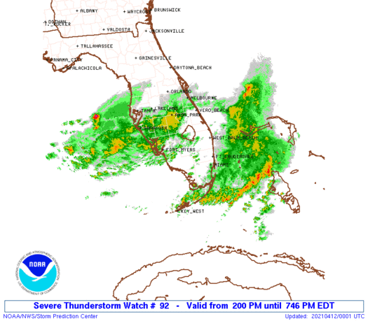
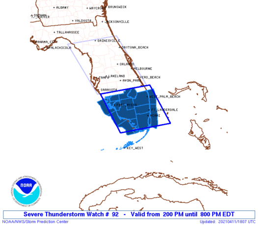
Severe Thunderstorm Watch Number 92
NWS Storm Prediction Center Norman OK
200 PM EDT Sun Apr 11 2021
The NWS Storm Prediction Center has issued a
* Severe Thunderstorm Watch for portions of
South Florida
Coastal Waters
* Effective this Sunday afternoon and evening from 200 PM until
800 PM EDT.
* Primary threats include...
Scattered damaging wind gusts to 70 mph possible
Isolated large hail events to 1 inch in diameter possible
SUMMARY...A band of storms with embedded clusters and bowing
segments will continue to develop southeastward across south Florida
through the afternoon. The strongest storms will be capable of
producing occasional damaging outflow winds and isolated large hail.
The severe thunderstorm watch area is approximately along and 80
statute miles east and west of a line from 60 miles northeast of
Fort Myers FL to 40 miles south southwest of Miami FL. For a
complete depiction of the watch see the associated watch outline
update (WOUS64 KWNS WOU2).
PRECAUTIONARY/PREPAREDNESS ACTIONS...
REMEMBER...A Severe Thunderstorm Watch means conditions are
favorable for severe thunderstorms in and close to the watch area.
Persons in these areas should be on the lookout for threatening
weather conditions and listen for later statements and possible
warnings. Severe thunderstorms can and occasionally do produce
tornadoes.
&&
OTHER WATCH INFORMATION...CONTINUE...WW 91...
AVIATION...A few severe thunderstorms with hail surface and aloft to
1 inch. Extreme turbulence and surface wind gusts to 60 knots. A few
cumulonimbi with maximum tops to 550. Mean storm motion vector
29035.
...Thompson
 Note:
The Aviation Watch (SAW) product is an approximation to the watch area.
The actual watch is depicted by the shaded areas.
Note:
The Aviation Watch (SAW) product is an approximation to the watch area.
The actual watch is depicted by the shaded areas.
   SAW2
   WW 92 SEVERE TSTM FL CW 111800Z - 120000Z
   AXIS..80 STATUTE MILES EAST AND WEST OF LINE..
   60NE FMY/FORT MYERS FL/ - 40SSW MIA/MIAMI FL/
   ..AVIATION COORDS.. 70NM E/W /47SW TRV - 34SSW MIA/
   HAIL SURFACE AND ALOFT..1 INCH. WIND GUSTS..60 KNOTS.
   MAX TOPS TO 550. MEAN STORM MOTION VECTOR 29035.

   LAT...LON 27197987 25267924 25268181 27198248

   THIS IS AN APPROXIMATION TO THE WATCH AREA.  FOR A
   COMPLETE DEPICTION OF THE WATCH SEE WOUS64 KWNS
   FOR WOU2.
Watch 92 Status Report Messages:
STATUS REPORT #4 ON WW 92

VALID 112225Z - 112340Z

SEVERE WEATHER THREAT CONTINUES RIGHT OF A LINE FROM 35 SSW APF
TO 30 SSE APF TO 25 W MIA TO 20 ESE MIA TO 45 E MIA TO 65 ENE MIA.

..JEWELL..04/11/21

ATTN...WFO...MFL...TBW...

&&

STATUS REPORT FOR WS 92

SEVERE WEATHER THREAT CONTINUES FOR THE FOLLOWING AREAS

FLC086-087-112340-

FL
.    FLORIDA COUNTIES INCLUDED ARE

MIAMI-DADE	     MONROE
$$


AMZ630-651-GMZ656-657-112340-

CW

.    ADJACENT COASTAL WATERS INCLUDED ARE

BISCAYNE BAY

COASTAL WATERS FROM DEERFIELD BEACH TO OCEAN REEF FL OUT 20 NM

COASTAL WATERS FROM CHOKOLOSKEE TO BONITA BEACH FL OUT 20 NM

COASTAL WATERS FROM EAST CAPE SABLE TO CHOKOLOSKEE FL OUT 20 NM

$$
THE WATCH STATUS MESSAGE IS FOR GUIDANCE PURPOSES ONLY.  PLEASE
REFER TO WATCH COUNTY NOTIFICATION STATEMENTS FOR OFFICIAL
INFORMATION ON COUNTIES...INDEPENDENT CITIES AND MARINE ZONES
CLEARED FROM SEVERE THUNDERSTORM AND TORNADO WATCHES.
$$

STATUS REPORT #3 ON WW 92

VALID 112130Z - 112240Z

SEVERE WEATHER THREAT CONTINUES RIGHT OF A LINE FROM 30 W APF TO
20 NE APF TO 45 ENE APF TO 40 NNW MIA TO 25 SSW PBI TO 45 SE PBI.

..JEWELL..04/11/21

ATTN...WFO...MFL...TBW...

&&

STATUS REPORT FOR WS 92

SEVERE WEATHER THREAT CONTINUES FOR THE FOLLOWING AREAS

FLC011-021-086-087-112240-

FL
.    FLORIDA COUNTIES INCLUDED ARE

BROWARD 	     COLLIER		 MIAMI-DADE
MONROE
$$


AMZ630-651-GMZ656-657-112240-

CW

.    ADJACENT COASTAL WATERS INCLUDED ARE

BISCAYNE BAY

COASTAL WATERS FROM DEERFIELD BEACH TO OCEAN REEF FL OUT 20 NM

COASTAL WATERS FROM CHOKOLOSKEE TO BONITA BEACH FL OUT 20 NM

COASTAL WATERS FROM EAST CAPE SABLE TO CHOKOLOSKEE FL OUT 20 NM

$$
THE WATCH STATUS MESSAGE IS FOR GUIDANCE PURPOSES ONLY.  PLEASE
REFER TO WATCH COUNTY NOTIFICATION STATEMENTS FOR OFFICIAL
INFORMATION ON COUNTIES...INDEPENDENT CITIES AND MARINE ZONES
CLEARED FROM SEVERE THUNDERSTORM AND TORNADO WATCHES.
$$

STATUS REPORT #2 ON WW 92

VALID 112125Z - 112240Z

SEVERE WEATHER THREAT CONTINUES RIGHT OF A LINE FROM 15 ESE SRQ
TO 10 SE FMY TO 20 NE APF TO 45 ENE APF TO 40 NNW MIA TO 25 SSW
PBI TO 45 SE PBI.

..JEWELL..04/11/21

ATTN...WFO...MFL...TBW...

&&

STATUS REPORT FOR WS 92

SEVERE WEATHER THREAT CONTINUES FOR THE FOLLOWING AREAS

FLC011-021-086-087-112240-

FL
.    FLORIDA COUNTIES INCLUDED ARE

BROWARD 	     COLLIER		 MIAMI-DADE
MONROE
$$


AMZ630-651-GMZ656-657-836-112240-

CW

.    ADJACENT COASTAL WATERS INCLUDED ARE

BISCAYNE BAY

COASTAL WATERS FROM DEERFIELD BEACH TO OCEAN REEF FL OUT 20 NM

COASTAL WATERS FROM CHOKOLOSKEE TO BONITA BEACH FL OUT 20 NM

COASTAL WATERS FROM EAST CAPE SABLE TO CHOKOLOSKEE FL OUT 20 NM

CHARLOTTE HARBOR AND PINE ISLAND SOUND

$$
THE WATCH STATUS MESSAGE IS FOR GUIDANCE PURPOSES ONLY.  PLEASE
REFER TO WATCH COUNTY NOTIFICATION STATEMENTS FOR OFFICIAL
INFORMATION ON COUNTIES...INDEPENDENT CITIES AND MARINE ZONES
CLEARED FROM SEVERE THUNDERSTORM AND TORNADO WATCHES.
$$

STATUS REPORT #1 ON WW 92

VALID 111935Z - 112040Z

THE SEVERE WEATHER THREAT CONTINUES ACROSS THE ENTIRE WATCH AREA.

..GUYER..04/11/21

ATTN...WFO...MFL...TBW...

&&

STATUS REPORT FOR WS 92

SEVERE WEATHER THREAT CONTINUES FOR THE FOLLOWING AREAS

FLC011-015-021-043-051-071-086-087-099-112040-

FL
.    FLORIDA COUNTIES INCLUDED ARE

BROWARD 	     CHARLOTTE		 COLLIER
GLADES		     HENDRY		 LEE
MIAMI-DADE	     MONROE		 PALM BEACH
$$


AMZ610-630-650-651-GMZ656-657-836-856-112040-

CW

.    ADJACENT COASTAL WATERS INCLUDED ARE

LAKE OKEECHOBEE

BISCAYNE BAY

COASTAL WATERS FROM JUPITER INLET TO DEERFIELD BEACH FL OUT 20 NM

COASTAL WATERS FROM DEERFIELD BEACH TO OCEAN REEF FL OUT 20 NM

COASTAL WATERS FROM CHOKOLOSKEE TO BONITA BEACH FL OUT 20 NM

COASTAL WATERS FROM EAST CAPE SABLE TO CHOKOLOSKEE FL OUT 20 NM

CHARLOTTE HARBOR AND PINE ISLAND SOUND

COASTAL WATERS FROM BONITA BEACH TO ENGLEWOOD FL OUT 20 NM

$$
THE WATCH STATUS MESSAGE IS FOR GUIDANCE PURPOSES ONLY.  PLEASE
REFER TO WATCH COUNTY NOTIFICATION STATEMENTS FOR OFFICIAL
INFORMATION ON COUNTIES...INDEPENDENT CITIES AND MARINE ZONES
CLEARED FROM SEVERE THUNDERSTORM AND TORNADO WATCHES.
$$
Note:
Click for Complete Product Text.
Tornadoes
Probability of 2 or more tornadoes
|
Low (10%)
|
Probability of 1 or more strong (EF2-EF5) tornadoes
|
Low (<2%)
|
Wind
Probability of 10 or more severe wind events
|
Mod (40%)
|
Probability of 1 or more wind events > 65 knots
|
Low (20%)
|
Hail
Probability of 10 or more severe hail events
|
Low (20%)
|
Probability of 1 or more hailstones > 2 inches
|
Low (10%)
|
Combined Severe Hail/Wind
Probability of 6 or more combined severe hail/wind events
|
Mod (60%)
|
For each watch, probabilities for particular events inside the watch
(listed above in each table) are determined by the issuing forecaster.
The "Low" category contains probability values ranging from less than 2%
to 20% (EF2-EF5 tornadoes), less than 5% to 20% (all other probabilities),
"Moderate" from 30% to 60%, and "High" from 70% to greater than 95%.
High values are bolded and lighter in color to provide awareness of
an increased threat for a particular event.


 @NWSSPC