Note:
The expiration time in the watch graphic is amended if the watch is
replaced, cancelled or extended.
Note:
Note:
The expiration time in the watch graphic is amended if the watch is
replaced, cancelled or extended.
Note: Click for
Watch Status Reports.
   SEL8

   URGENT - IMMEDIATE BROADCAST REQUESTED
   Severe Thunderstorm Watch Number 128
   NWS Storm Prediction Center Norman OK
   1150 AM CDT Mon May 3 2021

   The NWS Storm Prediction Center has issued a

   * Severe Thunderstorm Watch for portions of
     Alabama
     Eastern Mississippi

   * Effective this Monday morning and evening from 1150 AM until
     800 PM CDT.

   * Primary threats include...
     Scattered damaging wind gusts to 65 mph possible
     Isolated large hail events to 1.5 inches in diameter possible
     A tornado or two possible

   SUMMARY...Scattered thunderstorms are expected to be focused in two
   corridors of confluence across east-central to central Alabama and
   farther south in southern Alabama. Damaging winds and large hail are
   the primary threats.

   The severe thunderstorm watch area is approximately along and 105
   statute miles east and west of a line from 50 miles northwest of
   Birmingham AL to 40 miles south southeast of Evergreen AL. For a
   complete depiction of the watch see the associated watch outline
   update (WOUS64 KWNS WOU8).

   PRECAUTIONARY/PREPAREDNESS ACTIONS...

   REMEMBER...A Severe Thunderstorm Watch means conditions are
   favorable for severe thunderstorms in and close to the watch area.
   Persons in these areas should be on the lookout for threatening
   weather conditions and listen for later statements and possible
   warnings. Severe thunderstorms can and occasionally do produce
   tornadoes.

   &&

   OTHER WATCH INFORMATION...CONTINUE...WW 127...

   AVIATION...A few severe thunderstorms with hail surface and aloft to
   1.5 inches. Extreme turbulence and surface wind gusts to 55 knots. A
   few cumulonimbi with maximum tops to 500. Mean storm motion vector
   27025.

   ...Grams
 Note:
The Aviation Watch (SAW) product is an approximation to the watch area.
The actual watch is depicted by the shaded areas.
Note:
The Aviation Watch (SAW) product is an approximation to the watch area.
The actual watch is depicted by the shaded areas.
   SAW8
   WW 128 SEVERE TSTM AL MS 031650Z - 040100Z
   AXIS..105 STATUTE MILES EAST AND WEST OF LINE..
   50NW BHM/BIRMINGHAM AL/ - 40SSE GZH/EVERGREEN AL/
   ..AVIATION COORDS.. 90NM E/W /34NW VUZ - 6WNW CEW/
   HAIL SURFACE AND ALOFT..1.5 INCHES. WIND GUSTS..55 KNOTS.
   MAX TOPS TO 500. MEAN STORM MOTION VECTOR 27025.

   LAT...LON 34078553 30878501 30878855 34078920

   THIS IS AN APPROXIMATION TO THE WATCH AREA.  FOR A
   COMPLETE DEPICTION OF THE WATCH SEE WOUS64 KWNS
   FOR WOU8.
Watch 128 Status Report Messages:
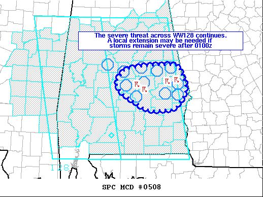
STATUS REPORT #5 ON WW 128

VALID 032355Z - 040040Z

SEVERE WEATHER THREAT CONTINUES RIGHT OF A LINE FROM 35 SSW CSG
TO 25 NW SEM TO 30 NW SEM TO 30 ESE TCL TO 15 NNW LGC.

..SQUITIERI..05/03/21

ATTN...WFO...BMX...MOB...TAE...JAN...

&&

STATUS REPORT FOR WS 128

SEVERE WEATHER THREAT CONTINUES FOR THE FOLLOWING AREAS

ALC001-007-017-021-037-051-081-087-101-113-123-040040-

AL
.    ALABAMA COUNTIES INCLUDED ARE

AUTAUGA 	     BIBB		 CHAMBERS
CHILTON 	     COOSA		 ELMORE
LEE		     MACON		 MONTGOMERY
RUSSELL 	     TALLAPOOSA
$$


THE WATCH STATUS MESSAGE IS FOR GUIDANCE PURPOSES ONLY.  PLEASE
REFER TO WATCH COUNTY NOTIFICATION STATEMENTS FOR OFFICIAL
INFORMATION ON COUNTIES...INDEPENDENT CITIES AND MARINE ZONES
CLEARED FROM SEVERE THUNDERSTORM AND TORNADO WATCHES.
$$

STATUS REPORT #4 ON WW 128

VALID 032315Z - 040040Z

THE SEVERE WEATHER THREAT CONTINUES ACROSS THE ENTIRE WATCH AREA.

..SQUITIERI..05/03/21

ATTN...WFO...BMX...MOB...TAE...JAN...

&&

STATUS REPORT FOR WS 128

SEVERE WEATHER THREAT CONTINUES FOR THE FOLLOWING AREAS

ALC001-007-017-021-027-037-051-081-087-101-111-113-123-040040-

AL
.    ALABAMA COUNTIES INCLUDED ARE

AUTAUGA 	     BIBB		 CHAMBERS
CHILTON 	     CLAY		 COOSA
ELMORE		     LEE		 MACON
MONTGOMERY	     RANDOLPH		 RUSSELL
TALLAPOOSA
$$


THE WATCH STATUS MESSAGE IS FOR GUIDANCE PURPOSES ONLY.  PLEASE
REFER TO WATCH COUNTY NOTIFICATION STATEMENTS FOR OFFICIAL
INFORMATION ON COUNTIES...INDEPENDENT CITIES AND MARINE ZONES
CLEARED FROM SEVERE THUNDERSTORM AND TORNADO WATCHES.
$$

STATUS REPORT #3 ON WW 128

VALID 032235Z - 032340Z

SEVERE WEATHER THREAT CONTINUES RIGHT OF A LINE FROM 40 NW MOB TO
50 E MEI TO 30 NW GAD.

..SQUITIERI..05/03/21

ATTN...WFO...BMX...MOB...TAE...JAN...

&&

STATUS REPORT FOR WS 128

SEVERE WEATHER THREAT CONTINUES FOR THE FOLLOWING AREAS

ALC001-005-007-009-011-013-015-017-019-021-025-027-029-031-035-
037-039-041-045-047-051-053-055-061-065-067-069-073-081-085-087-
091-099-101-105-109-111-113-115-117-121-123-129-131-032340-

AL
.    ALABAMA COUNTIES INCLUDED ARE

AUTAUGA 	     BARBOUR		 BIBB
BLOUNT		     BULLOCK		 BUTLER
CALHOUN 	     CHAMBERS		 CHEROKEE
CHILTON 	     CLARKE		 CLAY
CLEBURNE	     COFFEE		 CONECUH
COOSA		     COVINGTON		 CRENSHAW
DALE		     DALLAS		 ELMORE
ESCAMBIA	     ETOWAH		 GENEVA
HALE		     HENRY		 HOUSTON
JEFFERSON	     LEE		 LOWNDES
MACON		     MARENGO		 MONROE
MONTGOMERY	     PERRY		 PIKE
RANDOLPH	     RUSSELL		 ST. CLAIR
SHELBY		     TALLADEGA		 TALLAPOOSA
WASHINGTON	     WILCOX
$$


MSC153-032340-

MS
.    MISSISSIPPI COUNTIES INCLUDED ARE

WAYNE
$$


THE WATCH STATUS MESSAGE IS FOR GUIDANCE PURPOSES ONLY.  PLEASE
REFER TO WATCH COUNTY NOTIFICATION STATEMENTS FOR OFFICIAL
INFORMATION ON COUNTIES...INDEPENDENT CITIES AND MARINE ZONES
CLEARED FROM SEVERE THUNDERSTORM AND TORNADO WATCHES.
$$

STATUS REPORT #2 ON WW 128

VALID 032045Z - 032140Z

THE SEVERE WEATHER THREAT CONTINUES ACROSS THE ENTIRE WATCH AREA.

..SQUITIERI..05/03/21

ATTN...WFO...BMX...MOB...TAE...JAN...

&&

STATUS REPORT FOR WS 128

SEVERE WEATHER THREAT CONTINUES FOR THE FOLLOWING AREAS

ALC001-005-007-009-011-013-015-017-019-021-023-025-027-029-031-
035-037-039-041-045-047-051-053-055-057-061-063-065-067-069-073-
075-081-085-087-091-099-101-105-107-109-111-113-115-117-119-121-
123-125-127-129-131-032140-

AL
.    ALABAMA COUNTIES INCLUDED ARE

AUTAUGA 	     BARBOUR		 BIBB
BLOUNT		     BULLOCK		 BUTLER
CALHOUN 	     CHAMBERS		 CHEROKEE
CHILTON 	     CHOCTAW		 CLARKE
CLAY		     CLEBURNE		 COFFEE
CONECUH 	     COOSA		 COVINGTON
CRENSHAW	     DALE		 DALLAS
ELMORE		     ESCAMBIA		 ETOWAH
FAYETTE 	     GENEVA		 GREENE
HALE		     HENRY		 HOUSTON
JEFFERSON	     LAMAR		 LEE
LOWNDES 	     MACON		 MARENGO
MONROE		     MONTGOMERY 	 PERRY
PICKENS 	     PIKE		 RANDOLPH
RUSSELL 	     ST. CLAIR		 SHELBY
SUMTER		     TALLADEGA		 TALLAPOOSA
TUSCALOOSA	     WALKER		 WASHINGTON
WILCOX
$$


MSC007-019-023-025-061-069-075-079-087-097-099-101-103-105-123-
129-153-155-159-032140-

MS
.    MISSISSIPPI COUNTIES INCLUDED ARE

ATTALA		     CHOCTAW		 CLARKE
CLAY		     JASPER		 KEMPER
LAUDERDALE	     LEAKE		 LOWNDES
MONTGOMERY	     NESHOBA		 NEWTON
NOXUBEE 	     OKTIBBEHA		 SCOTT
SMITH		     WAYNE		 WEBSTER
WINSTON
$$


THE WATCH STATUS MESSAGE IS FOR GUIDANCE PURPOSES ONLY.  PLEASE
REFER TO WATCH COUNTY NOTIFICATION STATEMENTS FOR OFFICIAL
INFORMATION ON COUNTIES...INDEPENDENT CITIES AND MARINE ZONES
CLEARED FROM SEVERE THUNDERSTORM AND TORNADO WATCHES.
$$

STATUS REPORT #1 ON WW 128

VALID 031850Z - 031940Z

THE SEVERE WEATHER THREAT CONTINUES ACROSS THE ENTIRE WATCH AREA.

..DIAL..05/03/21

ATTN...WFO...BMX...MOB...TAE...JAN...

&&

STATUS REPORT FOR WS 128

SEVERE WEATHER THREAT CONTINUES FOR THE FOLLOWING AREAS

ALC001-005-007-009-011-013-015-017-019-021-023-025-027-029-031-
035-037-039-041-045-047-051-053-055-057-061-063-065-067-069-073-
075-081-085-087-091-099-101-105-107-109-111-113-115-117-119-121-
123-125-127-129-131-031940-

AL
.    ALABAMA COUNTIES INCLUDED ARE

AUTAUGA 	     BARBOUR		 BIBB
BLOUNT		     BULLOCK		 BUTLER
CALHOUN 	     CHAMBERS		 CHEROKEE
CHILTON 	     CHOCTAW		 CLARKE
CLAY		     CLEBURNE		 COFFEE
CONECUH 	     COOSA		 COVINGTON
CRENSHAW	     DALE		 DALLAS
ELMORE		     ESCAMBIA		 ETOWAH
FAYETTE 	     GENEVA		 GREENE
HALE		     HENRY		 HOUSTON
JEFFERSON	     LAMAR		 LEE
LOWNDES 	     MACON		 MARENGO
MONROE		     MONTGOMERY 	 PERRY
PICKENS 	     PIKE		 RANDOLPH
RUSSELL 	     ST. CLAIR		 SHELBY
SUMTER		     TALLADEGA		 TALLAPOOSA
TUSCALOOSA	     WALKER		 WASHINGTON
WILCOX
$$


MSC007-019-023-025-061-069-075-079-087-097-099-101-103-105-123-
129-153-155-159-031940-

MS
.    MISSISSIPPI COUNTIES INCLUDED ARE

ATTALA		     CHOCTAW		 CLARKE
CLAY		     JASPER		 KEMPER
LAUDERDALE	     LEAKE		 LOWNDES
MONTGOMERY	     NESHOBA		 NEWTON
NOXUBEE 	     OKTIBBEHA		 SCOTT
SMITH		     WAYNE		 WEBSTER
WINSTON
$$


THE WATCH STATUS MESSAGE IS FOR GUIDANCE PURPOSES ONLY.  PLEASE
REFER TO WATCH COUNTY NOTIFICATION STATEMENTS FOR OFFICIAL
INFORMATION ON COUNTIES...INDEPENDENT CITIES AND MARINE ZONES
CLEARED FROM SEVERE THUNDERSTORM AND TORNADO WATCHES.
$$
Note:
Click for Complete Product Text.
Tornadoes
Probability of 2 or more tornadoes
|
Low (20%)
|
Probability of 1 or more strong (EF2-EF5) tornadoes
|
Low (10%)
|
Wind
Probability of 10 or more severe wind events
|
Mod (40%)
|
Probability of 1 or more wind events > 65 knots
|
Low (20%)
|
Hail
Probability of 10 or more severe hail events
|
Mod (30%)
|
Probability of 1 or more hailstones > 2 inches
|
Low (20%)
|
Combined Severe Hail/Wind
Probability of 6 or more combined severe hail/wind events
|
High (70%)
|
For each watch, probabilities for particular events inside the watch
(listed above in each table) are determined by the issuing forecaster.
The "Low" category contains probability values ranging from less than 2%
to 20% (EF2-EF5 tornadoes), less than 5% to 20% (all other probabilities),
"Moderate" from 30% to 60%, and "High" from 70% to greater than 95%.
High values are bolded and lighter in color to provide awareness of
an increased threat for a particular event.


 @NWSSPC