 Note:
The expiration time in the watch graphic is amended if the watch is
replaced, cancelled or extended.
Note:
Note:
The expiration time in the watch graphic is amended if the watch is
replaced, cancelled or extended.
Note: Click for
Watch Status Reports.
SEL4
URGENT - IMMEDIATE BROADCAST REQUESTED
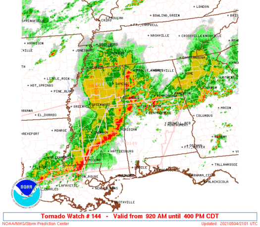
Tornado Watch Number 144
NWS Storm Prediction Center Norman OK
920 AM CDT Tue May 4 2021
The NWS Storm Prediction Center has issued a
* Tornado Watch for portions of
Alabama
Central Mississippi
* Effective this Tuesday morning and afternoon from 920 AM until
400 PM CDT.
* Primary threats include...
A few tornadoes possible
Widespread damaging winds likely with isolated significant gusts
to 75 mph possible
Isolated very large hail events to 2 inches in diameter possible
SUMMARY...A discrete supercell over central Mississippi may persist
this morning with additional discrete supercells possible into
west-central and southwest Alabama. Otherwise, an intensifying
squall line is expected to evolve east across northern and central
Alabama with damaging winds and a few tornadoes as the primary
hazards.
The tornado watch area is approximately along and 80 statute miles
east and west of a line from 40 miles north northwest of Gadsden AL
to 55 miles south southwest of Meridian MS. For a complete depiction
of the watch see the associated watch outline update (WOUS64 KWNS
WOU4).
PRECAUTIONARY/PREPAREDNESS ACTIONS...
REMEMBER...A Tornado Watch means conditions are favorable for
tornadoes and severe thunderstorms in and close to the watch
area. Persons in these areas should be on the lookout for
threatening weather conditions and listen for later statements
and possible warnings.
&&
OTHER WATCH INFORMATION...CONTINUE...WW 141...WW 142...WW 143...
AVIATION...Tornadoes and a few severe thunderstorms with hail
surface and aloft to 2 inches. Extreme turbulence and surface wind
gusts to 65 knots. A few cumulonimbi with maximum tops to 500. Mean
storm motion vector 25035.
...Grams
   SEL4

   URGENT - IMMEDIATE BROADCAST REQUESTED
   Tornado Watch Number 144
   NWS Storm Prediction Center Norman OK
   920 AM CDT Tue May 4 2021

   The NWS Storm Prediction Center has issued a

   * Tornado Watch for portions of
     Alabama
     Central Mississippi

   * Effective this Tuesday morning and afternoon from 920 AM until
     400 PM CDT.

   * Primary threats include...
     A few tornadoes possible
     Widespread damaging winds likely with isolated significant gusts
       to 75 mph possible
     Isolated very large hail events to 2 inches in diameter possible

   SUMMARY...A discrete supercell over central Mississippi may persist
   this morning with additional discrete supercells possible into
   west-central and southwest Alabama. Otherwise, an intensifying
   squall line is expected to evolve east across northern and central
   Alabama with damaging winds and a few tornadoes as the primary
   hazards.

   The tornado watch area is approximately along and 80 statute miles
   east and west of a line from 40 miles north northwest of Gadsden AL
   to 55 miles south southwest of Meridian MS. For a complete depiction
   of the watch see the associated watch outline update (WOUS64 KWNS
   WOU4).

   PRECAUTIONARY/PREPAREDNESS ACTIONS...

   REMEMBER...A Tornado Watch means conditions are favorable for
   tornadoes and severe thunderstorms in and close to the watch
   area. Persons in these areas should be on the lookout for
   threatening weather conditions and listen for later statements
   and possible warnings.

   &&

   OTHER WATCH INFORMATION...CONTINUE...WW 141...WW 142...WW 143...

   AVIATION...Tornadoes and a few severe thunderstorms with hail
   surface and aloft to 2 inches. Extreme turbulence and surface wind
   gusts to 65 knots. A few cumulonimbi with maximum tops to 500. Mean
   storm motion vector 25035.

   ...Grams
 Note:
The Aviation Watch (SAW) product is an approximation to the watch area.
The actual watch is depicted by the shaded areas.
Note:
The Aviation Watch (SAW) product is an approximation to the watch area.
The actual watch is depicted by the shaded areas.
SAW4
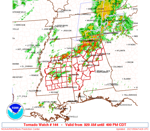
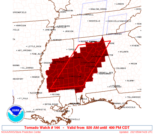
WW 144 TORNADO AL MS 041420Z - 042100Z
AXIS..80 STATUTE MILES EAST AND WEST OF LINE..
40NNW GAD/GADSDEN AL/ - 55SSW MEI/MERIDIAN MS/
..AVIATION COORDS.. 70NM E/W /57NNE VUZ - 50SSW MEI/
HAIL SURFACE AND ALOFT..2 INCHES. WIND GUSTS..65 KNOTS.
MAX TOPS TO 500. MEAN STORM MOTION VECTOR 25035.
LAT...LON 34508494 31598775 31599047 34508775
THIS IS AN APPROXIMATION TO THE WATCH AREA. FOR A
COMPLETE DEPICTION OF THE WATCH SEE WOUS64 KWNS
FOR WOU4.
Watch 144 Status Report Messages:
STATUS REPORT #3 ON WW 144

VALID 041925Z - 042040Z

THE SEVERE WEATHER THREAT CONTINUES ACROSS THE ENTIRE WATCH AREA.

FOR ADDITIONAL INFORMATION SEE MESOSCALE DISCUSSION 531

..MOSIER..05/04/21

ATTN...WFO...BMX...MOB...HUN...JAN...

&&

STATUS REPORT FOR WT 144

SEVERE WEATHER THREAT CONTINUES FOR THE FOLLOWING AREAS

ALC001-007-009-015-019-021-023-025-027-029-037-047-055-057-063-
065-073-075-091-105-107-115-117-119-121-125-127-129-131-133-
042040-

AL
.    ALABAMA COUNTIES INCLUDED ARE

AUTAUGA 	     BIBB		 BLOUNT
CALHOUN 	     CHEROKEE		 CHILTON
CHOCTAW 	     CLARKE		 CLAY
CLEBURNE	     COOSA		 DALLAS
ETOWAH		     FAYETTE		 GREENE
HALE		     JEFFERSON		 LAMAR
MARENGO 	     PERRY		 PICKENS
ST. CLAIR	     SHELBY		 SUMTER
TALLADEGA	     TUSCALOOSA 	 WALKER
WASHINGTON	     WILCOX		 WINSTON
$$


MSC007-015-019-023-025-029-031-049-051-061-065-067-069-075-077-
079-085-087-089-097-099-101-103-105-121-123-127-129-153-155-159-
163-042040-

MS
.    MISSISSIPPI COUNTIES INCLUDED ARE

ATTALA		     CARROLL		 CHOCTAW
CLARKE		     CLAY		 COPIAH
COVINGTON	     HINDS		 HOLMES
JASPER		     JEFFERSON DAVIS	 JONES
KEMPER		     LAUDERDALE 	 LAWRENCE
LEAKE		     LINCOLN		 LOWNDES
MADISON 	     MONTGOMERY 	 NESHOBA
NEWTON		     NOXUBEE		 OKTIBBEHA
RANKIN		     SCOTT		 SIMPSON
SMITH		     WAYNE		 WEBSTER
WINSTON 	     YAZOO
$$


THE WATCH STATUS MESSAGE IS FOR GUIDANCE PURPOSES ONLY.  PLEASE
REFER TO WATCH COUNTY NOTIFICATION STATEMENTS FOR OFFICIAL
INFORMATION ON COUNTIES...INDEPENDENT CITIES AND MARINE ZONES
CLEARED FROM SEVERE THUNDERSTORM AND TORNADO WATCHES.
$$

STATUS REPORT #2 ON WW 144

VALID 041800Z - 041940Z

THE SEVERE WEATHER THREAT CONTINUES ACROSS THE ENTIRE WATCH AREA.

FOR ADDITIONAL INFORMATION SEE MESOSCALE DISCUSSION 527

..MOSIER..05/04/21

ATTN...WFO...BMX...MOB...HUN...JAN...

&&

STATUS REPORT FOR WT 144

SEVERE WEATHER THREAT CONTINUES FOR THE FOLLOWING AREAS

ALC001-007-009-015-019-021-023-025-027-029-037-047-055-057-063-
065-073-075-091-105-107-115-117-119-121-125-127-129-131-133-
041940-

AL
.    ALABAMA COUNTIES INCLUDED ARE

AUTAUGA 	     BIBB		 BLOUNT
CALHOUN 	     CHEROKEE		 CHILTON
CHOCTAW 	     CLARKE		 CLAY
CLEBURNE	     COOSA		 DALLAS
ETOWAH		     FAYETTE		 GREENE
HALE		     JEFFERSON		 LAMAR
MARENGO 	     PERRY		 PICKENS
ST. CLAIR	     SHELBY		 SUMTER
TALLADEGA	     TUSCALOOSA 	 WALKER
WASHINGTON	     WILCOX		 WINSTON
$$


MSC007-015-019-023-025-029-031-049-051-061-065-067-069-075-077-
079-085-087-089-097-099-101-103-105-121-123-127-129-153-155-159-
163-041940-

MS
.    MISSISSIPPI COUNTIES INCLUDED ARE

ATTALA		     CARROLL		 CHOCTAW
CLARKE		     CLAY		 COPIAH
COVINGTON	     HINDS		 HOLMES
JASPER		     JEFFERSON DAVIS	 JONES
KEMPER		     LAUDERDALE 	 LAWRENCE
LEAKE		     LINCOLN		 LOWNDES
MADISON 	     MONTGOMERY 	 NESHOBA
NEWTON		     NOXUBEE		 OKTIBBEHA
RANKIN		     SCOTT		 SIMPSON
SMITH		     WAYNE		 WEBSTER
WINSTON 	     YAZOO
$$


THE WATCH STATUS MESSAGE IS FOR GUIDANCE PURPOSES ONLY.  PLEASE
REFER TO WATCH COUNTY NOTIFICATION STATEMENTS FOR OFFICIAL
INFORMATION ON COUNTIES...INDEPENDENT CITIES AND MARINE ZONES
CLEARED FROM SEVERE THUNDERSTORM AND TORNADO WATCHES.
$$

STATUS REPORT #1 ON WW 144

VALID 041640Z - 041740Z

THE SEVERE WEATHER THREAT CONTINUES ACROSS THE ENTIRE WATCH AREA.

..MOSIER..05/04/21

ATTN...WFO...BMX...MOB...HUN...JAN...

&&

STATUS REPORT FOR WT 144

SEVERE WEATHER THREAT CONTINUES FOR THE FOLLOWING AREAS

ALC001-007-009-015-019-021-023-025-027-029-037-043-047-049-055-
057-063-065-073-075-091-095-103-105-107-115-117-119-121-125-127-
129-131-133-041740-

AL
.    ALABAMA COUNTIES INCLUDED ARE

AUTAUGA 	     BIBB		 BLOUNT
CALHOUN 	     CHEROKEE		 CHILTON
CHOCTAW 	     CLARKE		 CLAY
CLEBURNE	     COOSA		 CULLMAN
DALLAS		     DEKALB		 ETOWAH
FAYETTE 	     GREENE		 HALE
JEFFERSON	     LAMAR		 MARENGO
MARSHALL	     MORGAN		 PERRY
PICKENS 	     ST. CLAIR		 SHELBY
SUMTER		     TALLADEGA		 TUSCALOOSA
WALKER		     WASHINGTON 	 WILCOX
WINSTON
$$


MSC007-015-019-023-025-029-031-049-051-061-065-067-069-075-077-
079-085-087-089-097-099-101-103-105-121-123-127-129-153-155-159-
163-041740-

MS
.    MISSISSIPPI COUNTIES INCLUDED ARE

ATTALA		     CARROLL		 CHOCTAW
CLARKE		     CLAY		 COPIAH
COVINGTON	     HINDS		 HOLMES
JASPER		     JEFFERSON DAVIS	 JONES
KEMPER		     LAUDERDALE 	 LAWRENCE
LEAKE		     LINCOLN		 LOWNDES
MADISON 	     MONTGOMERY 	 NESHOBA
NEWTON		     NOXUBEE		 OKTIBBEHA
RANKIN		     SCOTT		 SIMPSON
SMITH		     WAYNE		 WEBSTER
WINSTON 	     YAZOO
$$


THE WATCH STATUS MESSAGE IS FOR GUIDANCE PURPOSES ONLY.  PLEASE
REFER TO WATCH COUNTY NOTIFICATION STATEMENTS FOR OFFICIAL
INFORMATION ON COUNTIES...INDEPENDENT CITIES AND MARINE ZONES
CLEARED FROM SEVERE THUNDERSTORM AND TORNADO WATCHES.
$$
Note:
Click for Complete Product Text.
Tornadoes
Probability of 2 or more tornadoes
|
Mod (50%)
|
Probability of 1 or more strong (EF2-EF5) tornadoes
|
Low (20%)
|
Wind
Probability of 10 or more severe wind events
|
High (80%)
|
Probability of 1 or more wind events > 65 knots
|
Mod (40%)
|
Hail
Probability of 10 or more severe hail events
|
Mod (30%)
|
Probability of 1 or more hailstones > 2 inches
|
Mod (30%)
|
Combined Severe Hail/Wind
Probability of 6 or more combined severe hail/wind events
|
High (>95%)
|
For each watch, probabilities for particular events inside the watch
(listed above in each table) are determined by the issuing forecaster.
The "Low" category contains probability values ranging from less than 2%
to 20% (EF2-EF5 tornadoes), less than 5% to 20% (all other probabilities),
"Moderate" from 30% to 60%, and "High" from 70% to greater than 95%.
High values are bolded and lighter in color to provide awareness of
an increased threat for a particular event.


 @NWSSPC


