 Note:
The expiration time in the watch graphic is amended if the watch is
replaced, cancelled or extended.
Note:
Note:
The expiration time in the watch graphic is amended if the watch is
replaced, cancelled or extended.
Note: Click for
Watch Status Reports.
SEL0
URGENT - IMMEDIATE BROADCAST REQUESTED
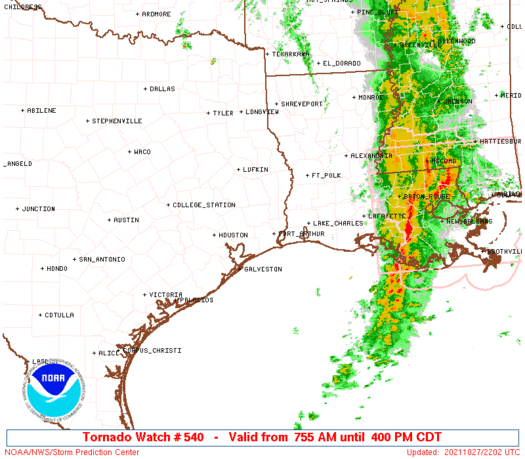
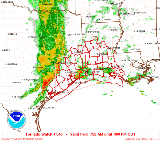
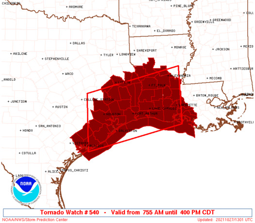
Tornado Watch Number 540
NWS Storm Prediction Center Norman OK
755 AM CDT Wed Oct 27 2021
The NWS Storm Prediction Center has issued a
* Tornado Watch for portions of
Southern and central Louisiana
Southeast Texas
Coastal Waters
* Effective this Wednesday morning and afternoon from 755 AM
until 400 PM CDT.
* Primary threats include...
A few tornadoes likely with a couple intense tornadoes possible
Widespread damaging wind gusts to 70 mph likely
SUMMARY...A line of storms will continue eastward initially across
east/southeast Texas this morning, with other storms increasing
ahead of it from far southeast Texas into southern/central Louisiana
this morning. Damaging winds will be a common concern with the
strongest storms, and the tornado potential is expected to increase
into late morning and afternoon. A couple of strong tornadoes are
possible, especially by late morning and early/mid-afternoon.
The tornado watch area is approximately along and 80 statute miles
north and south of a line from 30 miles north northeast of Lafayette
LA to 50 miles west of Houston TX. For a complete depiction of the
watch see the associated watch outline update (WOUS64 KWNS WOU0).
PRECAUTIONARY/PREPAREDNESS ACTIONS...
REMEMBER...A Tornado Watch means conditions are favorable for
tornadoes and severe thunderstorms in and close to the watch
area. Persons in these areas should be on the lookout for
threatening weather conditions and listen for later statements
and possible warnings.
&&
OTHER WATCH INFORMATION...CONTINUE...WW 539...
AVIATION...Tornadoes and a few severe thunderstorms with hail
surface and aloft to 1 inch. Extreme turbulence and surface wind
gusts to 60 knots. A few cumulonimbi with maximum tops to 500. Mean
storm motion vector 25025.
...Guyer
   SEL0

   URGENT - IMMEDIATE BROADCAST REQUESTED
   Tornado Watch Number 540
   NWS Storm Prediction Center Norman OK
   755 AM CDT Wed Oct 27 2021

   The NWS Storm Prediction Center has issued a

   * Tornado Watch for portions of
     Southern and central Louisiana
     Southeast Texas
     Coastal Waters

   * Effective this Wednesday morning and afternoon from 755 AM
     until 400 PM CDT.

   * Primary threats include...
     A few tornadoes likely with a couple intense tornadoes possible
     Widespread damaging wind gusts to 70 mph likely

   SUMMARY...A line of storms will continue eastward initially across
   east/southeast Texas this morning, with other storms increasing
   ahead of it from far southeast Texas into southern/central Louisiana
   this morning. Damaging winds will be a common concern with the
   strongest storms, and the tornado potential is expected to increase
   into late morning and afternoon. A couple of strong tornadoes are
   possible, especially by late morning and early/mid-afternoon.

   The tornado watch area is approximately along and 80 statute miles
   north and south of a line from 30 miles north northeast of Lafayette
   LA to 50 miles west of Houston TX. For a complete depiction of the
   watch see the associated watch outline update (WOUS64 KWNS WOU0).

   PRECAUTIONARY/PREPAREDNESS ACTIONS...

   REMEMBER...A Tornado Watch means conditions are favorable for
   tornadoes and severe thunderstorms in and close to the watch
   area. Persons in these areas should be on the lookout for
   threatening weather conditions and listen for later statements
   and possible warnings.

   &&

   OTHER WATCH INFORMATION...CONTINUE...WW 539...

   AVIATION...Tornadoes and a few severe thunderstorms with hail
   surface and aloft to 1 inch. Extreme turbulence and surface wind
   gusts to 60 knots. A few cumulonimbi with maximum tops to 500. Mean
   storm motion vector 25025.

   ...Guyer
 Note:
The Aviation Watch (SAW) product is an approximation to the watch area.
The actual watch is depicted by the shaded areas.
Note:
The Aviation Watch (SAW) product is an approximation to the watch area.
The actual watch is depicted by the shaded areas.
   SAW0
   WW 540 TORNADO LA TX CW 271255Z - 272100Z
   AXIS..80 STATUTE MILES NORTH AND SOUTH OF LINE..
   30NNE LFT/LAFAYETTE LA/ - 50W HOU/HOUSTON TX/
   ..AVIATION COORDS.. 70NM N/S /26WNW BTR - 44WSW IAH/
   HAIL SURFACE AND ALOFT..1 INCH. WIND GUSTS..60 KNOTS.
   MAX TOPS TO 500. MEAN STORM MOTION VECTOR 25025.

   LAT...LON 29449179 28499611 30819611 31769179

   THIS IS AN APPROXIMATION TO THE WATCH AREA.  FOR A
   COMPLETE DEPICTION OF THE WATCH SEE WOUS64 KWNS
   FOR WOU0.
Watch 540 Status Report Messages:
STATUS REPORT #6 ON WW 540
VALID 272030Z - 272140Z
SEVERE WEATHER THREAT CONTINUES RIGHT OF A LINE FROM 40 SSW 7R4
TO 15 NNE LFT TO 45 SE ESF.
..DIAL..10/27/21
ATTN...WFO...LCH...SHV...HGX...
&&
STATUS REPORT FOR WT 540
SEVERE WEATHER THREAT CONTINUES FOR THE FOLLOWING AREAS
LAC045-099-101-272140-
LA
. LOUISIANA PARISHES INCLUDED ARE
IBERIA ST. MARTIN ST. MARY
$$
GMZ435-272140-
CW
. ADJACENT COASTAL WATERS INCLUDED ARE
VERMILION BAY
$$
THE WATCH STATUS MESSAGE IS FOR GUIDANCE PURPOSES ONLY. PLEASE
REFER TO WATCH COUNTY NOTIFICATION STATEMENTS FOR OFFICIAL
INFORMATION ON COUNTIES...INDEPENDENT CITIES AND MARINE ZONES
CLEARED FROM SEVERE THUNDERSTORM AND TORNADO WATCHES.
$$
STATUS REPORT #5 ON WW 540
VALID 271915Z - 272040Z
SEVERE WEATHER THREAT CONTINUES RIGHT OF A LINE FROM 70 S LCH TO
35 WSW 7R4 TO 15 WNW LFT TO 40 SSE ESF TO 10 NNW ESF TO 20 NNW
ESF.
..DIAL..10/27/21
ATTN...WFO...LCH...SHV...HGX...
&&
STATUS REPORT FOR WT 540
SEVERE WEATHER THREAT CONTINUES FOR THE FOLLOWING AREAS
LAC001-009-045-055-097-099-101-113-272040-
LA
. LOUISIANA PARISHES INCLUDED ARE
ACADIA AVOYELLES IBERIA
LAFAYETTE ST. LANDRY ST. MARTIN
ST. MARY VERMILION
$$
GMZ435-452-455-272040-
CW
. ADJACENT COASTAL WATERS INCLUDED ARE
VERMILION BAY
COASTAL WATERS FROM INTRACOASTAL CITY TO CAMERON LA OUT 20 NM
COASTAL WATERS FROM LOWER ATCHAFALAYA RIVER TO INTRACOASTAL CITY
LA OUT 20 NM
$$
THE WATCH STATUS MESSAGE IS FOR GUIDANCE PURPOSES ONLY. PLEASE
REFER TO WATCH COUNTY NOTIFICATION STATEMENTS FOR OFFICIAL
INFORMATION ON COUNTIES...INDEPENDENT CITIES AND MARINE ZONES
CLEARED FROM SEVERE THUNDERSTORM AND TORNADO WATCHES.
$$
STATUS REPORT #4 ON WW 540
VALID 271755Z - 271840Z
SEVERE WEATHER THREAT CONTINUES RIGHT OF A LINE FROM 45 ESE GLS
TO 15 ENE LCH TO 20 ESE POE TO 15 SSE IER.
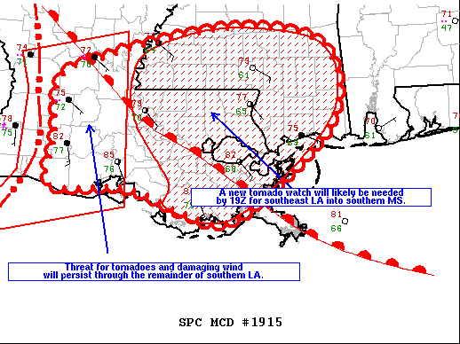
FOR ADDITIONAL INFORMATION SEE MESOSCALE DISCUSSION 1915
..DIAL..10/27/21
ATTN...WFO...LCH...SHV...HGX...
&&
STATUS REPORT FOR WT 540
SEVERE WEATHER THREAT CONTINUES FOR THE FOLLOWING AREAS
LAC001-003-009-023-039-043-045-053-055-069-079-097-099-101-113-
271840-
LA
. LOUISIANA PARISHES INCLUDED ARE
ACADIA ALLEN AVOYELLES
CAMERON EVANGELINE GRANT
IBERIA JEFFERSON DAVIS LAFAYETTE
NATCHITOCHES RAPIDES ST. LANDRY
ST. MARTIN ST. MARY VERMILION
$$
GMZ435-452-455-271840-
CW
. ADJACENT COASTAL WATERS INCLUDED ARE
VERMILION BAY
COASTAL WATERS FROM INTRACOASTAL CITY TO CAMERON LA OUT 20 NM
COASTAL WATERS FROM LOWER ATCHAFALAYA RIVER TO INTRACOASTAL CITY
LA OUT 20 NM
$$
THE WATCH STATUS MESSAGE IS FOR GUIDANCE PURPOSES ONLY. PLEASE
REFER TO WATCH COUNTY NOTIFICATION STATEMENTS FOR OFFICIAL
INFORMATION ON COUNTIES...INDEPENDENT CITIES AND MARINE ZONES
CLEARED FROM SEVERE THUNDERSTORM AND TORNADO WATCHES.
$$
STATUS REPORT #3 ON WW 540
VALID 271650Z - 271740Z
SEVERE WEATHER THREAT CONTINUES RIGHT OF A LINE FROM 30 SSE LBX
TO 15 ESE BPT TO 20 WSW POE TO 35 NW POE.
..DIAL..10/27/21
ATTN...WFO...LCH...SHV...HGX...
&&
STATUS REPORT FOR WT 540
SEVERE WEATHER THREAT CONTINUES FOR THE FOLLOWING AREAS
LAC001-003-009-011-019-023-039-043-045-053-055-069-079-085-097-
099-101-113-115-271740-
LA
. LOUISIANA PARISHES INCLUDED ARE
ACADIA ALLEN AVOYELLES
BEAUREGARD CALCASIEU CAMERON
EVANGELINE GRANT IBERIA
JEFFERSON DAVIS LAFAYETTE NATCHITOCHES
RAPIDES SABINE ST. LANDRY
ST. MARTIN ST. MARY VERMILION
VERNON
$$
GMZ430-432-435-450-452-455-271740-
CW
. ADJACENT COASTAL WATERS INCLUDED ARE
SABINE LAKE
CALCASIEU LAKE
VERMILION BAY
COASTAL WATERS FROM CAMERON LA TO HIGH ISLAND TX OUT 20 NM
COASTAL WATERS FROM INTRACOASTAL CITY TO CAMERON LA OUT 20 NM
COASTAL WATERS FROM LOWER ATCHAFALAYA RIVER TO INTRACOASTAL CITY
LA OUT 20 NM
$$
THE WATCH STATUS MESSAGE IS FOR GUIDANCE PURPOSES ONLY. PLEASE
REFER TO WATCH COUNTY NOTIFICATION STATEMENTS FOR OFFICIAL
INFORMATION ON COUNTIES...INDEPENDENT CITIES AND MARINE ZONES
CLEARED FROM SEVERE THUNDERSTORM AND TORNADO WATCHES.
$$
STATUS REPORT #2 ON WW 540
VALID 271520Z - 271640Z
SEVERE WEATHER THREAT CONTINUES RIGHT OF A LINE FROM 15 NNE PSX
TO 15 ESE HOU TO 45 NW BPT TO 20 E LFK.
FOR ADDITIONAL INFORMATION SEE MESOSCALE DISCUSSION 1912
..DIAL..10/27/21
ATTN...WFO...LCH...SHV...HGX...
&&
STATUS REPORT FOR WT 540
SEVERE WEATHER THREAT CONTINUES FOR THE FOLLOWING AREAS
LAC001-003-009-011-019-023-039-043-045-053-055-069-079-085-097-
099-101-113-115-271640-
LA
. LOUISIANA PARISHES INCLUDED ARE
ACADIA ALLEN AVOYELLES
BEAUREGARD CALCASIEU CAMERON
EVANGELINE GRANT IBERIA
JEFFERSON DAVIS LAFAYETTE NATCHITOCHES
RAPIDES SABINE ST. LANDRY
ST. MARTIN ST. MARY VERMILION
VERNON
$$
TXC039-071-167-199-241-245-291-321-351-361-403-405-457-271640-
TX
. TEXAS COUNTIES INCLUDED ARE
BRAZORIA CHAMBERS GALVESTON
HARDIN JASPER JEFFERSON
LIBERTY MATAGORDA NEWTON
ORANGE SABINE SAN AUGUSTINE
TYLER
$$
GMZ330-335-350-355-430-432-435-450-452-455-271640-
CW
. ADJACENT COASTAL WATERS INCLUDED ARE
MATAGORDA BAY
GALVESTON BAY
COASTAL WATERS FROM FREEPORT TO MATAGORDA SHIP CHANNEL TX OUT 20
NM
COASTAL WATERS FROM HIGH ISLAND TO FREEPORT TX OUT 20 NM
SABINE LAKE
CALCASIEU LAKE
VERMILION BAY
COASTAL WATERS FROM CAMERON LA TO HIGH ISLAND TX OUT 20 NM
COASTAL WATERS FROM INTRACOASTAL CITY TO CAMERON LA OUT 20 NM
COASTAL WATERS FROM LOWER ATCHAFALAYA RIVER TO INTRACOASTAL CITY
LA OUT 20 NM
$$
THE WATCH STATUS MESSAGE IS FOR GUIDANCE PURPOSES ONLY. PLEASE
REFER TO WATCH COUNTY NOTIFICATION STATEMENTS FOR OFFICIAL
INFORMATION ON COUNTIES...INDEPENDENT CITIES AND MARINE ZONES
CLEARED FROM SEVERE THUNDERSTORM AND TORNADO WATCHES.
$$
STATUS REPORT #1 ON WW 540
VALID 271415Z - 271540Z
SEVERE WEATHER THREAT CONTINUES RIGHT OF A LINE FROM 35 NNE PSX
TO 25 N HOU TO 20 E UTS TO 20 SW LFK.
FOR ADDITIONAL INFORMATION SEE MESOSCALE DISCUSSION 1912
..DIAL..10/27/21
ATTN...WFO...LCH...SHV...HGX...
&&
STATUS REPORT FOR WT 540
SEVERE WEATHER THREAT CONTINUES FOR THE FOLLOWING AREAS
LAC001-003-009-011-019-023-039-043-045-053-055-069-079-085-097-
099-101-113-115-271540-
LA
. LOUISIANA PARISHES INCLUDED ARE
ACADIA ALLEN AVOYELLES
BEAUREGARD CALCASIEU CAMERON
EVANGELINE GRANT IBERIA
JEFFERSON DAVIS LAFAYETTE NATCHITOCHES
RAPIDES SABINE ST. LANDRY
ST. MARTIN ST. MARY VERMILION
VERNON
$$
TXC005-039-071-157-167-199-201-239-241-245-291-321-351-361-373-
403-405-407-457-481-271540-
TX
. TEXAS COUNTIES INCLUDED ARE
ANGELINA BRAZORIA CHAMBERS
FORT BEND GALVESTON HARDIN
HARRIS JACKSON JASPER
JEFFERSON LIBERTY MATAGORDA
NEWTON ORANGE POLK
SABINE SAN AUGUSTINE SAN JACINTO
TYLER WHARTON
$$
GMZ330-335-350-355-430-432-435-450-452-455-271540-
CW
. ADJACENT COASTAL WATERS INCLUDED ARE
MATAGORDA BAY
GALVESTON BAY
COASTAL WATERS FROM FREEPORT TO MATAGORDA SHIP CHANNEL TX OUT 20
NM
COASTAL WATERS FROM HIGH ISLAND TO FREEPORT TX OUT 20 NM
SABINE LAKE
CALCASIEU LAKE
VERMILION BAY
COASTAL WATERS FROM CAMERON LA TO HIGH ISLAND TX OUT 20 NM
COASTAL WATERS FROM INTRACOASTAL CITY TO CAMERON LA OUT 20 NM
COASTAL WATERS FROM LOWER ATCHAFALAYA RIVER TO INTRACOASTAL CITY
LA OUT 20 NM
$$
THE WATCH STATUS MESSAGE IS FOR GUIDANCE PURPOSES ONLY. PLEASE
REFER TO WATCH COUNTY NOTIFICATION STATEMENTS FOR OFFICIAL
INFORMATION ON COUNTIES...INDEPENDENT CITIES AND MARINE ZONES
CLEARED FROM SEVERE THUNDERSTORM AND TORNADO WATCHES.
$$
Note:
Click for Complete Product Text.
Tornadoes
Probability of 2 or more tornadoes
|
High (70%)
|
Probability of 1 or more strong (EF2-EF5) tornadoes
|
Mod (50%)
|
Wind
Probability of 10 or more severe wind events
|
High (80%)
|
Probability of 1 or more wind events > 65 knots
|
Low (20%)
|
Hail
Probability of 10 or more severe hail events
|
Low (<5%)
|
Probability of 1 or more hailstones > 2 inches
|
Low (<5%)
|
Combined Severe Hail/Wind
Probability of 6 or more combined severe hail/wind events
|
High (90%)
|
For each watch, probabilities for particular events inside the watch
(listed above in each table) are determined by the issuing forecaster.
The "Low" category contains probability values ranging from less than 2%
to 20% (EF2-EF5 tornadoes), less than 5% to 20% (all other probabilities),
"Moderate" from 30% to 60%, and "High" from 70% to greater than 95%.
High values are bolded and lighter in color to provide awareness of
an increased threat for a particular event.


 @NWSSPC