 Note:
The expiration time in the watch graphic is amended if the watch is
replaced, cancelled or extended.
Note:
Note:
The expiration time in the watch graphic is amended if the watch is
replaced, cancelled or extended.
Note: Click for
Watch Status Reports.
SEL5
URGENT - IMMEDIATE BROADCAST REQUESTED
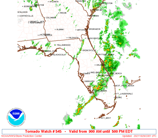
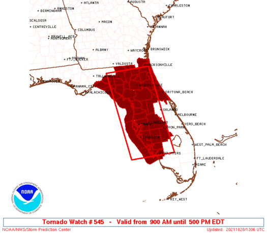
Tornado Watch Number 545
NWS Storm Prediction Center Norman OK
900 AM EDT Thu Oct 28 2021
The NWS Storm Prediction Center has issued a
* Tornado Watch for portions of
Florida
Coastal Waters
* Effective this Thursday morning and afternoon from 900 AM until
500 PM EDT.
* Primary threats include...
A few tornadoes possible
Scattered damaging wind gusts to 70 mph possible
SUMMARY...Severe thunderstorms including the potential for wind
damage and a few tornadoes will increase through late
morning/afternoon especially across the northern/western Florida
Peninsula as the air mass destabilizes and deep-layer/low-level
winds strengthen.
The tornado watch area is approximately along and 65 statute miles
east and west of a line from 55 miles north northwest of Gainesville
FL to 15 miles west southwest of Fort Myers FL. For a complete
depiction of the watch see the associated watch outline update
(WOUS64 KWNS WOU5).
PRECAUTIONARY/PREPAREDNESS ACTIONS...
REMEMBER...A Tornado Watch means conditions are favorable for
tornadoes and severe thunderstorms in and close to the watch
area. Persons in these areas should be on the lookout for
threatening weather conditions and listen for later statements
and possible warnings.
&&
AVIATION...Tornadoes and a few severe thunderstorms with hail
surface and aloft to 1 inch. Extreme turbulence and surface wind
gusts to 60 knots. A few cumulonimbi with maximum tops to 500. Mean
storm motion vector 22040.
...Guyer
 Note:
The Aviation Watch (SAW) product is an approximation to the watch area.
The actual watch is depicted by the shaded areas.
Note:
The Aviation Watch (SAW) product is an approximation to the watch area.
The actual watch is depicted by the shaded areas.
   SAW5
   WW 545 TORNADO FL CW 281300Z - 282100Z
   AXIS..65 STATUTE MILES EAST AND WEST OF LINE..
   55NNW GNV/GAINESVILLE FL/ - 15WSW FMY/FORT MYERS FL/
   ..AVIATION COORDS.. 55NM E/W /54NNE CTY - 17W RSW/
   HAIL SURFACE AND ALOFT..1 INCH. WIND GUSTS..60 KNOTS.
   MAX TOPS TO 500. MEAN STORM MOTION VECTOR 22040.

   LAT...LON 30418153 26498104 26498315 30418371

   THIS IS AN APPROXIMATION TO THE WATCH AREA.  FOR A
   COMPLETE DEPICTION OF THE WATCH SEE WOUS64 KWNS
   FOR WOU5.
Watch 545 Status Report Messages:
STATUS REPORT #6 ON WW 545

VALID 282035Z - 282140Z

SEVERE WEATHER THREAT CONTINUES RIGHT OF A LINE FROM 70 W FMY TO
15 WSW DAB.

FOR ADDITIONAL INFORMATION SEE MESOSCALE DISCUSSION 1924

..DIAL..10/28/21

ATTN...WFO...JAX...TBW...TAE...MLB...

&&

STATUS REPORT FOR WT 545

SEVERE WEATHER THREAT CONTINUES FOR THE FOLLOWING AREAS

FLC009-015-027-049-055-061-071-081-093-095-097-105-115-117-127-
282140-

FL
.    FLORIDA COUNTIES INCLUDED ARE

BREVARD 	     CHARLOTTE		 DESOTO
HARDEE		     HIGHLANDS		 INDIAN RIVER
LEE		     MANATEE		 OKEECHOBEE
ORANGE		     OSCEOLA		 POLK
SARASOTA	     SEMINOLE		 VOLUSIA
$$


GMZ836-856-282140-

CW

.    ADJACENT COASTAL WATERS INCLUDED ARE

CHARLOTTE HARBOR AND PINE ISLAND SOUND

COASTAL WATERS FROM BONITA BEACH TO ENGLEWOOD FL OUT 20 NM

$$
THE WATCH STATUS MESSAGE IS FOR GUIDANCE PURPOSES ONLY.  PLEASE
REFER TO WATCH COUNTY NOTIFICATION STATEMENTS FOR OFFICIAL
INFORMATION ON COUNTIES...INDEPENDENT CITIES AND MARINE ZONES
CLEARED FROM SEVERE THUNDERSTORM AND TORNADO WATCHES.
$$

STATUS REPORT #5 ON WW 545

VALID 281945Z - 282040Z

SEVERE WEATHER THREAT CONTINUES RIGHT OF A LINE FROM 70 SSW SRQ
TO 15 WNW DAB.

..DIAL..10/28/21

ATTN...WFO...JAX...TBW...TAE...MLB...

&&

STATUS REPORT FOR WT 545

SEVERE WEATHER THREAT CONTINUES FOR THE FOLLOWING AREAS

FLC015-027-049-055-071-081-095-097-105-115-117-127-282040-

FL
.    FLORIDA COUNTIES INCLUDED ARE

CHARLOTTE	     DESOTO		 HARDEE
HIGHLANDS	     LEE		 MANATEE
ORANGE		     OSCEOLA		 POLK
SARASOTA	     SEMINOLE		 VOLUSIA
$$


GMZ836-856-282040-

CW

.    ADJACENT COASTAL WATERS INCLUDED ARE

CHARLOTTE HARBOR AND PINE ISLAND SOUND

COASTAL WATERS FROM BONITA BEACH TO ENGLEWOOD FL OUT 20 NM

$$
THE WATCH STATUS MESSAGE IS FOR GUIDANCE PURPOSES ONLY.  PLEASE
REFER TO WATCH COUNTY NOTIFICATION STATEMENTS FOR OFFICIAL
INFORMATION ON COUNTIES...INDEPENDENT CITIES AND MARINE ZONES
CLEARED FROM SEVERE THUNDERSTORM AND TORNADO WATCHES.
$$

STATUS REPORT #4 ON WW 545

VALID 281840Z - 281940Z

SEVERE WEATHER THREAT CONTINUES RIGHT OF A LINE FROM 45 W SRQ TO
30 NW DAB.

FOR ADDITIONAL INFORMATION SEE MESOSCALE DISCUSSION 1923

..DIAL..10/28/21

ATTN...WFO...JAX...TBW...TAE...MLB...

&&

STATUS REPORT FOR WT 545

SEVERE WEATHER THREAT CONTINUES FOR THE FOLLOWING AREAS

FLC015-027-049-055-057-069-071-081-095-097-101-103-105-115-117-
127-281940-

FL
.    FLORIDA COUNTIES INCLUDED ARE

CHARLOTTE	     DESOTO		 HARDEE
HIGHLANDS	     HILLSBOROUGH	 LAKE
LEE		     MANATEE		 ORANGE
OSCEOLA 	     PASCO		 PINELLAS
POLK		     SARASOTA		 SEMINOLE
VOLUSIA
$$


GMZ830-836-853-856-281940-

CW

.    ADJACENT COASTAL WATERS INCLUDED ARE

TAMPA BAY WATERS

CHARLOTTE HARBOR AND PINE ISLAND SOUND

COASTAL WATERS FROM ENGLEWOOD TO TARPON SPRINGS FL OUT 20 NM

COASTAL WATERS FROM BONITA BEACH TO ENGLEWOOD FL OUT 20 NM

$$
THE WATCH STATUS MESSAGE IS FOR GUIDANCE PURPOSES ONLY.  PLEASE
REFER TO WATCH COUNTY NOTIFICATION STATEMENTS FOR OFFICIAL
INFORMATION ON COUNTIES...INDEPENDENT CITIES AND MARINE ZONES
CLEARED FROM SEVERE THUNDERSTORM AND TORNADO WATCHES.
$$

STATUS REPORT #3 ON WW 545

VALID 281715Z - 281840Z

SEVERE WEATHER THREAT CONTINUES RIGHT OF A LINE FROM 40 WSW PIE
TO 20 WSW JAX.

..DIAL..10/28/21

ATTN...WFO...JAX...TBW...TAE...MLB...

&&

STATUS REPORT FOR WT 545

SEVERE WEATHER THREAT CONTINUES FOR THE FOLLOWING AREAS

FLC001-007-015-017-019-027-031-035-049-053-055-057-069-071-081-
083-089-095-101-103-105-107-109-115-117-119-125-127-281840-

FL
.    FLORIDA COUNTIES INCLUDED ARE

ALACHUA 	     BRADFORD		 CHARLOTTE
CITRUS		     CLAY		 DESOTO
DUVAL		     FLAGLER		 HARDEE
HERNANDO	     HIGHLANDS		 HILLSBOROUGH
LAKE		     LEE		 MANATEE
MARION		     NASSAU		 ORANGE
PASCO		     PINELLAS		 POLK
PUTNAM		     ST. JOHNS		 SARASOTA
SEMINOLE	     SUMTER		 UNION
VOLUSIA
$$


GMZ830-836-853-856-281840-

CW

.    ADJACENT COASTAL WATERS INCLUDED ARE

TAMPA BAY WATERS

CHARLOTTE HARBOR AND PINE ISLAND SOUND

COASTAL WATERS FROM ENGLEWOOD TO TARPON SPRINGS FL OUT 20 NM

COASTAL WATERS FROM BONITA BEACH TO ENGLEWOOD FL OUT 20 NM

$$
THE WATCH STATUS MESSAGE IS FOR GUIDANCE PURPOSES ONLY.  PLEASE
REFER TO WATCH COUNTY NOTIFICATION STATEMENTS FOR OFFICIAL
INFORMATION ON COUNTIES...INDEPENDENT CITIES AND MARINE ZONES
CLEARED FROM SEVERE THUNDERSTORM AND TORNADO WATCHES.
$$

STATUS REPORT #2 ON WW 545

VALID 281555Z - 281640Z

SEVERE WEATHER THREAT CONTINUES RIGHT OF A LINE FROM 45 WNW PIE
TO 25 WSW JAX.

FOR ADDITIONAL INFORMATION SEE MESOSCALE DISCUSSION 1922

..DIAL..10/28/21

ATTN...WFO...JAX...TBW...TAE...MLB...

&&

STATUS REPORT FOR WT 545

SEVERE WEATHER THREAT CONTINUES FOR THE FOLLOWING AREAS

FLC001-007-015-017-019-027-031-035-049-053-055-057-069-071-081-
083-089-101-103-105-107-109-115-119-125-127-281640-

FL
.    FLORIDA COUNTIES INCLUDED ARE

ALACHUA 	     BRADFORD		 CHARLOTTE
CITRUS		     CLAY		 DESOTO
DUVAL		     FLAGLER		 HARDEE
HERNANDO	     HIGHLANDS		 HILLSBOROUGH
LAKE		     LEE		 MANATEE
MARION		     NASSAU		 PASCO
PINELLAS	     POLK		 PUTNAM
ST. JOHNS	     SARASOTA		 SUMTER
UNION		     VOLUSIA
$$


GMZ830-836-850-853-856-281640-

CW

.    ADJACENT COASTAL WATERS INCLUDED ARE

TAMPA BAY WATERS

CHARLOTTE HARBOR AND PINE ISLAND SOUND

COASTAL WATERS FROM TARPON SPRINGS TO SUWANNEE RIVER FL OUT 20 NM

COASTAL WATERS FROM ENGLEWOOD TO TARPON SPRINGS FL OUT 20 NM

COASTAL WATERS FROM BONITA BEACH TO ENGLEWOOD FL OUT 20 NM

$$
THE WATCH STATUS MESSAGE IS FOR GUIDANCE PURPOSES ONLY.  PLEASE
REFER TO WATCH COUNTY NOTIFICATION STATEMENTS FOR OFFICIAL
INFORMATION ON COUNTIES...INDEPENDENT CITIES AND MARINE ZONES
CLEARED FROM SEVERE THUNDERSTORM AND TORNADO WATCHES.
$$

STATUS REPORT #1 ON WW 545

VALID 281425Z - 281540Z

THE SEVERE WEATHER THREAT CONTINUES ACROSS THE ENTIRE WATCH AREA.

..DIAL..10/28/21

ATTN...WFO...JAX...TBW...TAE...MLB...

&&

STATUS REPORT FOR WT 545

SEVERE WEATHER THREAT CONTINUES FOR THE FOLLOWING AREAS

FLC001-003-007-015-017-019-023-027-029-031-035-041-047-049-053-
055-057-067-069-071-075-081-083-089-101-103-105-107-109-115-119-
121-123-125-127-281540-

FL
.    FLORIDA COUNTIES INCLUDED ARE

ALACHUA 	     BAKER		 BRADFORD
CHARLOTTE	     CITRUS		 CLAY
COLUMBIA	     DESOTO		 DIXIE
DUVAL		     FLAGLER		 GILCHRIST
HAMILTON	     HARDEE		 HERNANDO
HIGHLANDS	     HILLSBOROUGH	 LAFAYETTE
LAKE		     LEE		 LEVY
MANATEE 	     MARION		 NASSAU
PASCO		     PINELLAS		 POLK
PUTNAM		     ST. JOHNS		 SARASOTA
SUMTER		     SUWANNEE		 TAYLOR
UNION		     VOLUSIA
$$


GMZ730-765-830-836-850-853-856-281540-

CW

.    ADJACENT COASTAL WATERS INCLUDED ARE

APALACHEE BAY OR COASTAL WATERS FROM KEATON BEACH TO OCHLOCKONEE
RIVER FL OUT TO 20 NM

COASTAL WATERS FROM  SUWANNEE RIVER TO KEATON BEACH OUT 20 NM

TAMPA BAY WATERS

CHARLOTTE HARBOR AND PINE ISLAND SOUND

COASTAL WATERS FROM TARPON SPRINGS TO SUWANNEE RIVER FL OUT 20 NM

COASTAL WATERS FROM ENGLEWOOD TO TARPON SPRINGS FL OUT 20 NM

COASTAL WATERS FROM BONITA BEACH TO ENGLEWOOD FL OUT 20 NM

$$
THE WATCH STATUS MESSAGE IS FOR GUIDANCE PURPOSES ONLY.  PLEASE
REFER TO WATCH COUNTY NOTIFICATION STATEMENTS FOR OFFICIAL
INFORMATION ON COUNTIES...INDEPENDENT CITIES AND MARINE ZONES
CLEARED FROM SEVERE THUNDERSTORM AND TORNADO WATCHES.
$$
Note:
Click for Complete Product Text.
Tornadoes
Probability of 2 or more tornadoes
|
Mod (50%)
|
Probability of 1 or more strong (EF2-EF5) tornadoes
|
Low (20%)
|
Wind
Probability of 10 or more severe wind events
|
Mod (40%)
|
Probability of 1 or more wind events > 65 knots
|
Low (10%)
|
Hail
Probability of 10 or more severe hail events
|
Low (<5%)
|
Probability of 1 or more hailstones > 2 inches
|
Low (<5%)
|
Combined Severe Hail/Wind
Probability of 6 or more combined severe hail/wind events
|
Mod (60%)
|
For each watch, probabilities for particular events inside the watch
(listed above in each table) are determined by the issuing forecaster.
The "Low" category contains probability values ranging from less than 2%
to 20% (EF2-EF5 tornadoes), less than 5% to 20% (all other probabilities),
"Moderate" from 30% to 60%, and "High" from 70% to greater than 95%.
High values are bolded and lighter in color to provide awareness of
an increased threat for a particular event.


 @NWSSPC


