|
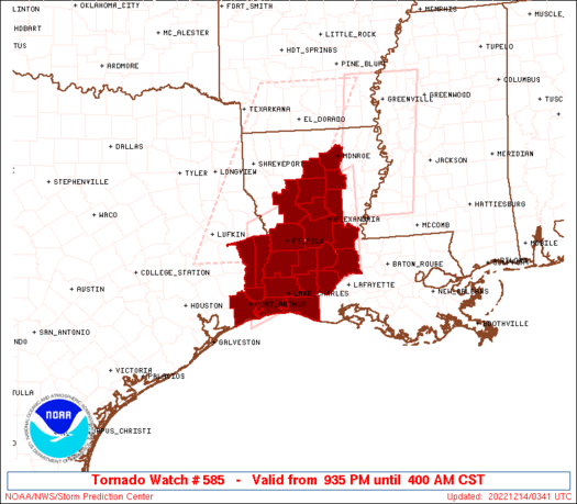
Initial List of Counties in SPC Tornado Watch 585 (WOU)
|
Back to Watch 585
|
 |
   WOUS64 KWNS 140330
   WOU5

   BULLETIN - IMMEDIATE BROADCAST REQUESTED
   TORNADO WATCH OUTLINE UPDATE FOR WT 585
   NWS STORM PREDICTION CENTER NORMAN OK
   935 PM CST TUE DEC 13 2022

   TORNADO WATCH 585 IS IN EFFECT UNTIL 400 AM CST FOR THE
    FOLLOWING LOCATIONS

   LAC001-003-009-011-019-021-023-039-043-049-053-059-069-073-079-
   097-115-127-141000-
   /O.NEW.KWNS.TO.A.0585.221214T0335Z-221214T1000Z/

   LA
   .    LOUISIANA PARISHES INCLUDED ARE

   ACADIA               ALLEN               AVOYELLES
   BEAUREGARD           CALCASIEU           CALDWELL
   CAMERON              EVANGELINE          GRANT
   JACKSON              JEFFERSON DAVIS     LA SALLE
   NATCHITOCHES         OUACHITA            RAPIDES
   ST. LANDRY           VERNON              WINN


   TXC241-245-351-361-141000-
   /O.NEW.KWNS.TO.A.0585.221214T0335Z-221214T1000Z/

   TX
   .    TEXAS COUNTIES INCLUDED ARE

   JASPER               JEFFERSON           NEWTON
   ORANGE


   GMZ430-432-141000-
   /O.NEW.KWNS.TO.A.0585.221214T0335Z-221214T1000Z/

   CW

   .    ADJACENT COASTAL WATERS INCLUDED ARE

   SABINE LAKE

   CALCASIEU LAKE

   ATTN...WFO...LCH...SHV...
|
| Aviation Watch (SAW) for WW585 |
|---|
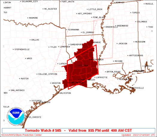 |
| Note:
The Aviation Watch (SAW) product is an approximation to the watch area.
The actual watch is depicted by the shaded areas. |
   SAW5
   WW 585 TORNADO LA TX CW 140335Z - 141000Z
   AXIS..65 STATUTE MILES NORTH AND SOUTH OF LINE..
   35E ESF/ALEXANDRIA LA/ - 35N BPT/PORT ARTHUR TX/
   ..AVIATION COORDS.. 55NM N/S /42ENE AEX - 51WNW LCH/
   HAIL SURFACE AND ALOFT..1.5 INCHES. WIND GUSTS..60 KNOTS.
   MAX TOPS TO 450. MEAN STORM MOTION VECTOR 23030.

   LAT...LON 30469171 29529402 31409402 32349171

   THIS IS AN APPROXIMATION TO THE WATCH AREA.  FOR A
   COMPLETE DEPICTION OF THE WATCH SEE WOUS64 KWNS
   FOR WOU5.
|
|


 @NWSSPC
