 Note:
The expiration time in the watch graphic is amended if the watch is
replaced, cancelled or extended.
Note:
Note:
The expiration time in the watch graphic is amended if the watch is
replaced, cancelled or extended.
Note: Click for
Watch Status Reports.
SEL5
URGENT - IMMEDIATE BROADCAST REQUESTED
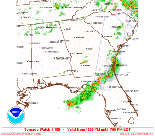
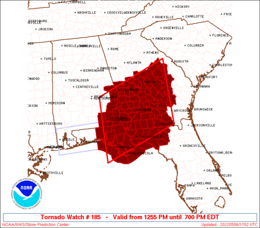
Tornado Watch Number 185
NWS Storm Prediction Center Norman OK
1255 PM EDT Fri May 6 2022
The NWS Storm Prediction Center has issued a
* Tornado Watch for portions of
Southeast Alabama
Northern Florida
Central and Southern Georgia
Coastal Waters
* Effective this Friday afternoon and evening from 1255 PM until
700 PM EDT.
* Primary threats include...
A few tornadoes possible
Scattered damaging wind gusts to 70 mph likely
Isolated large hail events to 1.5 inches in diameter possible
SUMMARY...The air mass across the region should steadily moisten and
destabilize with a severe/tornado risk expanding north-northeastward
into Georgia through the afternoon. Tornadoes are possible aside
from damaging winds and hail.
The tornado watch area is approximately along and 100 statute miles
north and south of a line from 45 miles southwest of Dothan AL to 60
miles north of Waycross GA. For a complete depiction of the watch
see the associated watch outline update (WOUS64 KWNS WOU5).
PRECAUTIONARY/PREPAREDNESS ACTIONS...
REMEMBER...A Tornado Watch means conditions are favorable for
tornadoes and severe thunderstorms in and close to the watch
area. Persons in these areas should be on the lookout for
threatening weather conditions and listen for later statements
and possible warnings.
&&
OTHER WATCH INFORMATION...CONTINUE...WW 184...
AVIATION...Tornadoes and a few severe thunderstorms with hail
surface and aloft to 1.5 inches. Extreme turbulence and surface wind
gusts to 60 knots. A few cumulonimbi with maximum tops to 550. Mean
storm motion vector 26035.
...Guyer
 Note:
The Aviation Watch (SAW) product is an approximation to the watch area.
The actual watch is depicted by the shaded areas.
Note:
The Aviation Watch (SAW) product is an approximation to the watch area.
The actual watch is depicted by the shaded areas.
   SAW5
   WW 185 TORNADO AL FL GA CW 061655Z - 062300Z
   AXIS..100 STATUTE MILES NORTH AND SOUTH OF LINE..
   45SW DHN/DOTHAN AL/ - 60N AYS/WAYCROSS GA/
   ..AVIATION COORDS.. 85NM N/S /36E CEW - 35N AMG/
   HAIL SURFACE AND ALOFT..1.5 INCHES. WIND GUSTS..60 KNOTS.
   MAX TOPS TO 550. MEAN STORM MOTION VECTOR 26035.

   LAT...LON 32318599 33578240 30678240 29418599

   THIS IS AN APPROXIMATION TO THE WATCH AREA.  FOR A
   COMPLETE DEPICTION OF THE WATCH SEE WOUS64 KWNS
   FOR WOU5.
Watch 185 Status Report Messages:
STATUS REPORT #4 ON WW 185

VALID 062215Z - 062340Z

SEVERE WEATHER THREAT CONTINUES RIGHT OF A LINE FROM 55 SSW PFN
TO 30 WSW TLH TO 35 WSW VLD TO 15 NNE VLD TO 40 WNW AYS TO 35 ENE
ABY TO 30 NNE ABY TO 25 S MCN TO 55 WSW AGS TO 20 WNW AGS.

..BENTLEY..05/06/22

ATTN...WFO...BMX...TAE...JAX...FFC...

&&

STATUS REPORT FOR WT 185

SEVERE WEATHER THREAT CONTINUES FOR THE FOLLOWING AREAS

FLC037-045-047-065-067-079-121-123-129-062340-

FL
.    FLORIDA COUNTIES INCLUDED ARE

FRANKLIN	     GULF		 HAMILTON
JEFFERSON	     LAFAYETTE		 MADISON
SUWANNEE	     TAYLOR		 WAKULLA
$$


GAC001-003-005-023-065-069-081-091-093-101-107-125-161-163-167-
173-175-185-209-235-271-279-283-303-309-315-319-062340-

GA
.    GEORGIA COUNTIES INCLUDED ARE

APPLING 	     ATKINSON		 BACON
BLECKLEY	     CLINCH		 COFFEE
CRISP		     DODGE		 DOOLY
ECHOLS		     EMANUEL		 GLASCOCK
JEFF DAVIS	     JEFFERSON		 JOHNSON
LANIER		     LAURENS		 LOWNDES
MONTGOMERY	     PULASKI		 TELFAIR
TOOMBS		     TREUTLEN		 WASHINGTON
WHEELER 	     WILCOX		 WILKINSON
$$


GMZ730-752-755-062340-

CW

.    ADJACENT COASTAL WATERS INCLUDED ARE

APALACHEE BAY OR COASTAL WATERS FROM KEATON BEACH TO OCHLOCKONEE
RIVER FL OUT TO 20 NM

COASTAL WATERS FROM MEXICO BEACH TO APALACHICOLA OUT 20 NM

COASTAL WATERS FROM  OCHLOCKONEE RIVER TO APALACHICOLA FL OUT TO
20 NM

$$
THE WATCH STATUS MESSAGE IS FOR GUIDANCE PURPOSES ONLY.  PLEASE
REFER TO WATCH COUNTY NOTIFICATION STATEMENTS FOR OFFICIAL
INFORMATION ON COUNTIES...INDEPENDENT CITIES AND MARINE ZONES
CLEARED FROM SEVERE THUNDERSTORM AND TORNADO WATCHES.
$$

STATUS REPORT #3 ON WW 185

VALID 062035Z - 062140Z

SEVERE WEATHER THREAT CONTINUES RIGHT OF A LINE FROM 40 WSW PFN
TO 15 ENE MAI TO 40 SSW MCN TO 25 ENE MCN TO 20 NW AGS.

..LEITMAN..05/06/22

ATTN...WFO...BMX...TAE...JAX...FFC...

&&

STATUS REPORT FOR WT 185

SEVERE WEATHER THREAT CONTINUES FOR THE FOLLOWING AREAS

FLC005-013-037-039-045-047-065-067-073-077-079-121-123-129-
062140-

FL
.    FLORIDA COUNTIES INCLUDED ARE

BAY		     CALHOUN		 FRANKLIN
GADSDEN 	     GULF		 HAMILTON
JEFFERSON	     LAFAYETTE		 LEON
LIBERTY 	     MADISON		 SUWANNEE
TAYLOR		     WAKULLA
$$


GAC001-003-005-007-017-019-023-027-065-069-071-075-081-087-091-
093-095-101-107-125-131-155-161-163-167-173-175-177-185-201-205-
209-235-253-271-275-277-279-283-287-303-309-315-319-321-
062140-

GA
.    GEORGIA COUNTIES INCLUDED ARE

APPLING 	     ATKINSON		 BACON
BAKER		     BEN HILL		 BERRIEN
BLECKLEY	     BROOKS		 CLINCH
COFFEE		     COLQUITT		 COOK
CRISP		     DECATUR		 DODGE
DOOLY		     DOUGHERTY		 ECHOLS
EMANUEL 	     GLASCOCK		 GRADY
IRWIN		     JEFF DAVIS 	 JEFFERSON
JOHNSON 	     LANIER		 LAURENS
LEE		     LOWNDES		 MILLER
MITCHELL	     MONTGOMERY 	 PULASKI
SEMINOLE	     TELFAIR		 THOMAS
TIFT		     TOOMBS		 TREUTLEN
TURNER		     WASHINGTON 	 WHEELER
WILCOX		     WILKINSON		 WORTH
$$


GMZ730-750-752-755-062140-

CW

.    ADJACENT COASTAL WATERS INCLUDED ARE

APALACHEE BAY OR COASTAL WATERS FROM KEATON BEACH TO OCHLOCKONEE
RIVER FL OUT TO 20 NM

COASTAL WATERS FROM OKALOOSA-WALTON COUNTY LINE TO MEXICO BEACH
OUT 20 NM

COASTAL WATERS FROM MEXICO BEACH TO APALACHICOLA OUT 20 NM

COASTAL WATERS FROM  OCHLOCKONEE RIVER TO APALACHICOLA FL OUT TO
20 NM

$$
THE WATCH STATUS MESSAGE IS FOR GUIDANCE PURPOSES ONLY.  PLEASE
REFER TO WATCH COUNTY NOTIFICATION STATEMENTS FOR OFFICIAL
INFORMATION ON COUNTIES...INDEPENDENT CITIES AND MARINE ZONES
CLEARED FROM SEVERE THUNDERSTORM AND TORNADO WATCHES.
$$

STATUS REPORT #2 ON WW 185

VALID 061925Z - 062040Z

SEVERE WEATHER THREAT CONTINUES RIGHT OF A LINE FROM 25 SSW TOI
TO 30 NNW ABY TO 20 NNE MCN TO 40 S AHN.

FOR ADDITIONAL INFORMATION SEE MESOSCALE DISCUSSION 676.

..LEITMAN..05/06/22

ATTN...WFO...BMX...TAE...JAX...FFC...

&&

STATUS REPORT FOR WT 185

SEVERE WEATHER THREAT CONTINUES FOR THE FOLLOWING AREAS

ALC031-045-061-067-069-062040-

AL
.    ALABAMA COUNTIES INCLUDED ARE

COFFEE		     DALE		 GENEVA
HENRY		     HOUSTON
$$


FLC005-013-037-039-045-047-059-063-065-067-073-077-079-121-123-
129-131-133-062040-

FL
.    FLORIDA COUNTIES INCLUDED ARE

BAY		     CALHOUN		 FRANKLIN
GADSDEN 	     GULF		 HAMILTON
HOLMES		     JACKSON		 JEFFERSON
LAFAYETTE	     LEON		 LIBERTY
MADISON 	     SUWANNEE		 TAYLOR
WAKULLA 	     WALTON		 WASHINGTON
$$


GAC001-003-005-007-009-017-019-023-027-037-061-065-069-071-075-
081-087-091-093-095-099-101-107-125-131-141-153-155-161-163-167-
169-173-175-177-185-193-201-205-209-235-243-253-261-271-273-275-
277-279-283-287-289-301-303-309-315-319-321-062040-

GA
.    GEORGIA COUNTIES INCLUDED ARE

APPLING 	     ATKINSON		 BACON
BAKER		     BALDWIN		 BEN HILL
BERRIEN 	     BLECKLEY		 BROOKS
CALHOUN 	     CLAY		 CLINCH
COFFEE		     COLQUITT		 COOK
CRISP		     DECATUR		 DODGE
DOOLY		     DOUGHERTY		 EARLY
ECHOLS		     EMANUEL		 GLASCOCK
GRADY		     HANCOCK		 HOUSTON
IRWIN		     JEFF DAVIS 	 JEFFERSON
JOHNSON 	     JONES		 LANIER
LAURENS 	     LEE		 LOWNDES
MACON		     MILLER		 MITCHELL
MONTGOMERY	     PULASKI		 RANDOLPH
SEMINOLE	     SUMTER		 TELFAIR
TERRELL 	     THOMAS		 TIFT
TOOMBS		     TREUTLEN		 TURNER
TWIGGS		     WARREN		 WASHINGTON
WHEELER 	     WILCOX		 WILKINSON
WORTH
$$


GMZ730-750-752-755-062040-

CW

.    ADJACENT COASTAL WATERS INCLUDED ARE

APALACHEE BAY OR COASTAL WATERS FROM KEATON BEACH TO OCHLOCKONEE
RIVER FL OUT TO 20 NM

COASTAL WATERS FROM OKALOOSA-WALTON COUNTY LINE TO MEXICO BEACH
OUT 20 NM

COASTAL WATERS FROM MEXICO BEACH TO APALACHICOLA OUT 20 NM

COASTAL WATERS FROM  OCHLOCKONEE RIVER TO APALACHICOLA FL OUT TO
20 NM

$$
THE WATCH STATUS MESSAGE IS FOR GUIDANCE PURPOSES ONLY.  PLEASE
REFER TO WATCH COUNTY NOTIFICATION STATEMENTS FOR OFFICIAL
INFORMATION ON COUNTIES...INDEPENDENT CITIES AND MARINE ZONES
CLEARED FROM SEVERE THUNDERSTORM AND TORNADO WATCHES.
$$

STATUS REPORT #1 ON WW 185

VALID 061825Z - 061940Z

THE SEVERE WEATHER THREAT CONTINUES ACROSS THE ENTIRE WATCH AREA.

..LEITMAN..05/06/22

ATTN...WFO...BMX...TAE...JAX...FFC...

&&

STATUS REPORT FOR WT 185

SEVERE WEATHER THREAT CONTINUES FOR THE FOLLOWING AREAS

ALC005-031-045-061-067-069-081-113-061940-

AL
.    ALABAMA COUNTIES INCLUDED ARE

BARBOUR 	     COFFEE		 DALE
GENEVA		     HENRY		 HOUSTON
LEE		     RUSSELL
$$


FLC005-013-037-039-045-047-059-063-065-067-073-077-079-121-123-
129-131-133-061940-

FL
.    FLORIDA COUNTIES INCLUDED ARE

BAY		     CALHOUN		 FRANKLIN
GADSDEN 	     GULF		 HAMILTON
HOLMES		     JACKSON		 JEFFERSON
LAFAYETTE	     LEON		 LIBERTY
MADISON 	     SUWANNEE		 TAYLOR
WAKULLA 	     WALTON		 WASHINGTON
$$


GAC001-003-005-007-009-017-019-021-023-027-037-053-061-065-069-
071-075-079-081-087-091-093-095-099-101-107-125-131-141-145-153-
155-161-163-167-169-173-175-177-185-193-197-201-205-207-209-215-
225-235-239-243-249-253-259-261-263-269-271-273-275-277-279-283-
287-289-293-301-303-307-309-315-319-321-061940-

GA
.    GEORGIA COUNTIES INCLUDED ARE

APPLING 	     ATKINSON		 BACON
BAKER		     BALDWIN		 BEN HILL
BERRIEN 	     BIBB		 BLECKLEY
BROOKS		     CALHOUN		 CHATTAHOOCHEE
CLAY		     CLINCH		 COFFEE
COLQUITT	     COOK		 CRAWFORD
CRISP		     DECATUR		 DODGE
DOOLY		     DOUGHERTY		 EARLY
ECHOLS		     EMANUEL		 GLASCOCK
GRADY		     HANCOCK		 HARRIS
HOUSTON 	     IRWIN		 JEFF DAVIS
JEFFERSON	     JOHNSON		 JONES
LANIER		     LAURENS		 LEE
LOWNDES 	     MACON		 MARION
MILLER		     MITCHELL		 MONROE
MONTGOMERY	     MUSCOGEE		 PEACH
PULASKI 	     QUITMAN		 RANDOLPH
SCHLEY		     SEMINOLE		 STEWART
SUMTER		     TALBOT		 TAYLOR
TELFAIR 	     TERRELL		 THOMAS
TIFT		     TOOMBS		 TREUTLEN
TURNER		     TWIGGS		 UPSON
WARREN		     WASHINGTON 	 WEBSTER
WHEELER 	     WILCOX		 WILKINSON
WORTH
$$


GMZ730-750-752-755-061940-

CW

.    ADJACENT COASTAL WATERS INCLUDED ARE

APALACHEE BAY OR COASTAL WATERS FROM KEATON BEACH TO OCHLOCKONEE
RIVER FL OUT TO 20 NM

COASTAL WATERS FROM OKALOOSA-WALTON COUNTY LINE TO MEXICO BEACH
OUT 20 NM

COASTAL WATERS FROM MEXICO BEACH TO APALACHICOLA OUT 20 NM

COASTAL WATERS FROM  OCHLOCKONEE RIVER TO APALACHICOLA FL OUT TO
20 NM

$$
THE WATCH STATUS MESSAGE IS FOR GUIDANCE PURPOSES ONLY.  PLEASE
REFER TO WATCH COUNTY NOTIFICATION STATEMENTS FOR OFFICIAL
INFORMATION ON COUNTIES...INDEPENDENT CITIES AND MARINE ZONES
CLEARED FROM SEVERE THUNDERSTORM AND TORNADO WATCHES.
$$
Note:
Click for Complete Product Text.
Tornadoes
Probability of 2 or more tornadoes
|
Mod (50%)
|
Probability of 1 or more strong (EF2-EF5) tornadoes
|
Low (20%)
|
Wind
Probability of 10 or more severe wind events
|
Mod (60%)
|
Probability of 1 or more wind events > 65 knots
|
Low (20%)
|
Hail
Probability of 10 or more severe hail events
|
Mod (30%)
|
Probability of 1 or more hailstones > 2 inches
|
Low (20%)
|
Combined Severe Hail/Wind
Probability of 6 or more combined severe hail/wind events
|
High (80%)
|
For each watch, probabilities for particular events inside the watch
(listed above in each table) are determined by the issuing forecaster.
The "Low" category contains probability values ranging from less than 2%
to 20% (EF2-EF5 tornadoes), less than 5% to 20% (all other probabilities),
"Moderate" from 30% to 60%, and "High" from 70% to greater than 95%.
High values are bolded and lighter in color to provide awareness of
an increased threat for a particular event.


 @NWSSPC


