 Note:
The expiration time in the watch graphic is amended if the watch is
replaced, cancelled or extended.
Note:
Note:
The expiration time in the watch graphic is amended if the watch is
replaced, cancelled or extended.
Note: Click for
Watch Status Reports.
SEL8
URGENT - IMMEDIATE BROADCAST REQUESTED
Severe Thunderstorm Watch Number 258
NWS Storm Prediction Center Norman OK
330 PM CDT Sat May 21 2022
The NWS Storm Prediction Center has issued a
* Severe Thunderstorm Watch for portions of
Southwest Arkansas
Southeast Oklahoma
Central and Northeast Texas
* Effective this Saturday afternoon and evening from 330 PM until
1100 PM CDT.
* Primary threats include...
Scattered large hail and isolated very large hail events to 2.5
inches in diameter possible
Scattered damaging wind gusts to 70 mph possible
A tornado or two possible
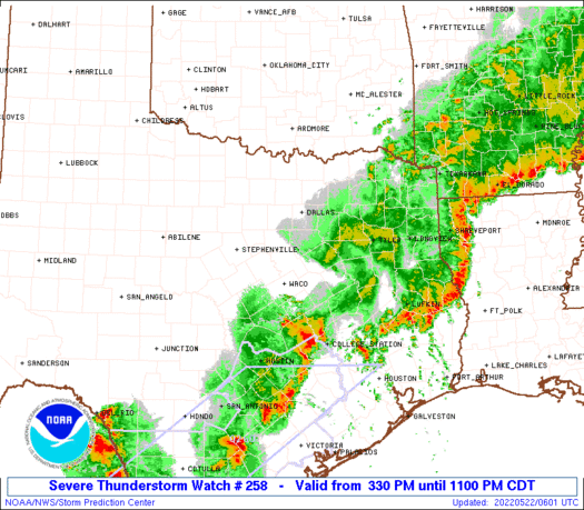
SUMMARY...Thunderstorms are beginning to form along a cold front
that stretches from southeast Oklahoma into central Texas. The
strongest storms in this zone will pose a risk of large hail and
damaging wind gusts through the evening.
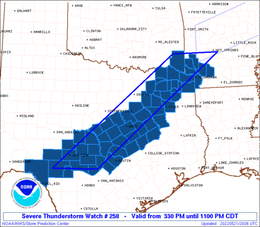
The severe thunderstorm watch area is approximately along and 60
statute miles east and west of a line from 40 miles south southeast
of Junction TX to 35 miles northeast of De Queen AR. For a complete
depiction of the watch see the associated watch outline update
(WOUS64 KWNS WOU8).
PRECAUTIONARY/PREPAREDNESS ACTIONS...
REMEMBER...A Severe Thunderstorm Watch means conditions are
favorable for severe thunderstorms in and close to the watch area.
Persons in these areas should be on the lookout for threatening
weather conditions and listen for later statements and possible
warnings. Severe thunderstorms can and occasionally do produce
tornadoes.
&&
OTHER WATCH INFORMATION...CONTINUE...WW 254...WW 255...WW
256...WW 257...
AVIATION...A few severe thunderstorms with hail surface and aloft to
2.5 inches. Extreme turbulence and surface wind gusts to 60 knots. A
few cumulonimbi with maximum tops to 500. Mean storm motion vector
24025.
...Hart
 Note:
The Aviation Watch (SAW) product is an approximation to the watch area.
The actual watch is depicted by the shaded areas.
Note:
The Aviation Watch (SAW) product is an approximation to the watch area.
The actual watch is depicted by the shaded areas.
   SAW8
   WW 258 SEVERE TSTM AR OK TX 212030Z - 220400Z
   AXIS..60 STATUTE MILES EAST AND WEST OF LINE..
   40SSE JCT/JUNCTION TX/ - 35NE DEQ/DE QUEEN AR/
   ..AVIATION COORDS.. 50NM E/W /40SSE JCT - 54N TXK/
   HAIL SURFACE AND ALOFT..2.5 INCHES. WIND GUSTS..60 KNOTS.
   MAX TOPS TO 500. MEAN STORM MOTION VECTOR 24025.

   LAT...LON 29980052 34409502 34409291 29989851

   THIS IS AN APPROXIMATION TO THE WATCH AREA.  FOR A
   COMPLETE DEPICTION OF THE WATCH SEE WOUS64 KWNS
   FOR WOU8.
Watch 258 Status Report Messages:
STATUS REPORT #6 ON WW 258

VALID 220235Z - 220340Z

SEVERE WEATHER THREAT CONTINUES RIGHT OF A LINE FROM 20 S DRT TO
45 E JCT TO 45 W TPL TO 15 SSE TPL TO 25 W CRS TO 20 SSE DAL TO
45 E DAL TO 20 WSW DEQ TO 40 WNW HOT.

FOR ADDITIONAL INFORMATION SEE MESOSCALE DISCUSSION 866

..MOORE..05/22/22

ATTN...WFO...SHV...FWD...EWX...SJT...

&&

STATUS REPORT FOR WS 258

SEVERE WEATHER THREAT CONTINUES FOR THE FOLLOWING AREAS

ARC027-057-061-073-081-091-099-133-220340-

AR
.    ARKANSAS COUNTIES INCLUDED ARE

COLUMBIA	     HEMPSTEAD		 HOWARD
LAFAYETTE	     LITTLE RIVER	 MILLER
NEVADA		     SEVIER
$$


LAC015-017-220340-

LA
.    LOUISIANA PARISHES INCLUDED ARE

BOSSIER 	     CADDO
$$


TXC001-005-019-029-031-037-053-063-067-073-091-145-159-161-171-
183-203-209-213-223-257-259-265-289-293-299-315-325-343-347-349-
365-379-385-387-395-401-403-405-419-423-449-453-459-463-467-491-
499-220340-

TX
.    TEXAS COUNTIES INCLUDED ARE

ANDERSON	     ANGELINA		 BANDERA
BEXAR		     BLANCO		 BOWIE
BURNET		     CAMP		 CASS
CHEROKEE	     COMAL		 FALLS
FRANKLIN	     FREESTONE		 GILLESPIE
GREGG		     HARRISON		 HAYS
HENDERSON	     HOPKINS		 KAUFMAN
KENDALL 	     KERR		 LEON
LIMESTONE	     LLANO		 MARION
MEDINA		     MORRIS		 NACOGDOCHES
NAVARRO 	     PANOLA		 RAINS
REAL		     RED RIVER		 ROBERTSON
RUSK		     SABINE		 SAN AUGUSTINE
SHELBY		     SMITH		 TITUS
TRAVIS		     UPSHUR		 UVALDE
VAN ZANDT	     WILLIAMSON 	 WOOD
$$


THE WATCH STATUS MESSAGE IS FOR GUIDANCE PURPOSES ONLY.  PLEASE
REFER TO WATCH COUNTY NOTIFICATION STATEMENTS FOR OFFICIAL
INFORMATION ON COUNTIES...INDEPENDENT CITIES AND MARINE ZONES
CLEARED FROM SEVERE THUNDERSTORM AND TORNADO WATCHES.
$$

STATUS REPORT #5 ON WW 258

VALID 220150Z - 220240Z

SEVERE WEATHER THREAT CONTINUES RIGHT OF A LINE FROM 15 SW DRT TO
30 SW JCT TO 40 E JCT TO 55 SSE BWD TO 20 NNE ACT TO 35 SSW RKR.

FOR ADDITIONAL INFORMATION SEE MESOSCALE DISCUSSION 866

..MOORE..05/22/22

ATTN...WFO...SHV...FWD...EWX...SJT...

&&

STATUS REPORT FOR WS 258

SEVERE WEATHER THREAT CONTINUES FOR THE FOLLOWING AREAS

ARC057-061-081-091-099-133-220240-

AR
.    ARKANSAS COUNTIES INCLUDED ARE

HEMPSTEAD	     HOWARD		 LITTLE RIVER
MILLER		     NEVADA		 SEVIER
$$


OKC089-220240-

OK
.    OKLAHOMA COUNTIES INCLUDED ARE

MCCURTAIN
$$


TXC001-019-027-029-031-037-053-063-067-091-099-137-145-159-161-
171-209-213-223-257-259-265-281-289-293-299-309-325-331-343-349-
379-385-387-395-423-449-453-459-463-467-491-499-220240-

TX
.    TEXAS COUNTIES INCLUDED ARE

ANDERSON	     BANDERA		 BELL
BEXAR		     BLANCO		 BOWIE
BURNET		     CAMP		 CASS
COMAL		     CORYELL		 EDWARDS
FALLS		     FRANKLIN		 FREESTONE
GILLESPIE	     HAYS		 HENDERSON
HOPKINS 	     KAUFMAN		 KENDALL
KERR		     LAMPASAS		 LEON
LIMESTONE	     LLANO		 MCLENNAN
MEDINA		     MILAM		 MORRIS
NAVARRO 	     RAINS		 REAL
RED RIVER	     ROBERTSON		 SMITH
TITUS		     TRAVIS		 UPSHUR
UVALDE		     VAN ZANDT		 WILLIAMSON
WOOD
$$


THE WATCH STATUS MESSAGE IS FOR GUIDANCE PURPOSES ONLY.  PLEASE
REFER TO WATCH COUNTY NOTIFICATION STATEMENTS FOR OFFICIAL
INFORMATION ON COUNTIES...INDEPENDENT CITIES AND MARINE ZONES
CLEARED FROM SEVERE THUNDERSTORM AND TORNADO WATCHES.
$$

STATUS REPORT #4 ON WW 258

VALID 220030Z - 220140Z

SEVERE WEATHER THREAT CONTINUES RIGHT OF A LINE FROM 65 ENE 6R6
TO 10 SE JCT TO 50 SE BWD TO 40 SSE FTW TO 30 ESE DAL TO 10 SSW
PRX TO 35 SSW RKR.

..BUNTING..05/22/22

ATTN...WFO...SHV...FWD...EWX...SJT...

&&

STATUS REPORT FOR WS 258

SEVERE WEATHER THREAT CONTINUES FOR THE FOLLOWING AREAS

ARC057-061-081-091-099-133-220140-

AR
.    ARKANSAS COUNTIES INCLUDED ARE

HEMPSTEAD	     HOWARD		 LITTLE RIVER
MILLER		     NEVADA		 SEVIER
$$


OKC089-220140-

OK
.    OKLAHOMA COUNTIES INCLUDED ARE

MCCURTAIN
$$


TXC001-019-027-031-037-053-063-067-099-137-145-159-161-171-209-
213-217-223-257-259-265-281-289-293-299-309-331-343-349-379-385-
387-395-423-449-453-459-465-467-491-499-220140-

TX
.    TEXAS COUNTIES INCLUDED ARE

ANDERSON	     BANDERA		 BELL
BLANCO		     BOWIE		 BURNET
CAMP		     CASS		 CORYELL
EDWARDS 	     FALLS		 FRANKLIN
FREESTONE	     GILLESPIE		 HAYS
HENDERSON	     HILL		 HOPKINS
KAUFMAN 	     KENDALL		 KERR
LAMPASAS	     LEON		 LIMESTONE
LLANO		     MCLENNAN		 MILAM
MORRIS		     NAVARRO		 RAINS
REAL		     RED RIVER		 ROBERTSON
SMITH		     TITUS		 TRAVIS
UPSHUR		     VAL VERDE		 VAN ZANDT
WILLIAMSON	     WOOD
$$


THE WATCH STATUS MESSAGE IS FOR GUIDANCE PURPOSES ONLY.  PLEASE
REFER TO WATCH COUNTY NOTIFICATION STATEMENTS FOR OFFICIAL
INFORMATION ON COUNTIES...INDEPENDENT CITIES AND MARINE ZONES
CLEARED FROM SEVERE THUNDERSTORM AND TORNADO WATCHES.
$$

STATUS REPORT #3 ON WW 258

VALID 212330Z - 220040Z

THE SEVERE WEATHER THREAT CONTINUES ACROSS THE ENTIRE WATCH AREA.

FOR ADDITIONAL INFORMATION SEE MESOSCALE DISCUSSION 863

..BUNTING..05/21/22

ATTN...WFO...SHV...FWD...EWX...SJT...

&&

STATUS REPORT FOR WS 258

SEVERE WEATHER THREAT CONTINUES FOR THE FOLLOWING AREAS

ARC057-061-081-091-099-133-220040-

AR
.    ARKANSAS COUNTIES INCLUDED ARE

HEMPSTEAD	     HOWARD		 LITTLE RIVER
MILLER		     NEVADA		 SEVIER
$$


OKC089-220040-

OK
.    OKLAHOMA COUNTIES INCLUDED ARE

MCCURTAIN
$$


TXC001-027-031-035-037-053-063-067-099-119-137-139-145-159-161-
171-193-209-213-217-223-231-257-259-265-267-277-281-289-293-299-
307-309-319-327-331-333-343-349-379-385-387-395-397-411-423-435-
449-453-459-465-467-491-499-220040-

TX
.    TEXAS COUNTIES INCLUDED ARE

ANDERSON	     BELL		 BLANCO
BOSQUE		     BOWIE		 BURNET
CAMP		     CASS		 CORYELL
DELTA		     EDWARDS		 ELLIS
FALLS		     FRANKLIN		 FREESTONE
GILLESPIE	     HAMILTON		 HAYS
HENDERSON	     HILL		 HOPKINS
HUNT		     KAUFMAN		 KENDALL
KERR		     KIMBLE		 LAMAR
LAMPASAS	     LEON		 LIMESTONE
LLANO		     MCCULLOCH		 MCLENNAN
MASON		     MENARD		 MILAM
MILLS		     MORRIS		 NAVARRO
RAINS		     REAL		 RED RIVER
ROBERTSON	     ROCKWALL		 SAN SABA
SMITH		     SUTTON		 TITUS
TRAVIS		     UPSHUR		 VAL VERDE
VAN ZANDT	     WILLIAMSON 	 WOOD
$$


THE WATCH STATUS MESSAGE IS FOR GUIDANCE PURPOSES ONLY.  PLEASE
REFER TO WATCH COUNTY NOTIFICATION STATEMENTS FOR OFFICIAL
INFORMATION ON COUNTIES...INDEPENDENT CITIES AND MARINE ZONES
CLEARED FROM SEVERE THUNDERSTORM AND TORNADO WATCHES.
$$

STATUS REPORT #2 ON WW 258

VALID 212230Z - 212340Z

THE SEVERE WEATHER THREAT CONTINUES ACROSS THE ENTIRE WATCH AREA.

..BUNTING..05/21/22

ATTN...WFO...SHV...FWD...EWX...SJT...

&&

STATUS REPORT FOR WS 258

SEVERE WEATHER THREAT CONTINUES FOR THE FOLLOWING AREAS

ARC057-061-081-091-099-133-212340-

AR
.    ARKANSAS COUNTIES INCLUDED ARE

HEMPSTEAD	     HOWARD		 LITTLE RIVER
MILLER		     NEVADA		 SEVIER
$$


OKC089-212340-

OK
.    OKLAHOMA COUNTIES INCLUDED ARE

MCCURTAIN
$$


TXC001-027-031-035-037-053-063-067-099-119-137-139-145-159-161-
171-193-209-213-217-223-231-257-259-265-267-277-281-289-293-299-
307-309-319-327-331-333-343-349-379-385-387-395-397-411-423-435-
449-453-459-465-467-491-499-212340-

TX
.    TEXAS COUNTIES INCLUDED ARE

ANDERSON	     BELL		 BLANCO
BOSQUE		     BOWIE		 BURNET
CAMP		     CASS		 CORYELL
DELTA		     EDWARDS		 ELLIS
FALLS		     FRANKLIN		 FREESTONE
GILLESPIE	     HAMILTON		 HAYS
HENDERSON	     HILL		 HOPKINS
HUNT		     KAUFMAN		 KENDALL
KERR		     KIMBLE		 LAMAR
LAMPASAS	     LEON		 LIMESTONE
LLANO		     MCCULLOCH		 MCLENNAN
MASON		     MENARD		 MILAM
MILLS		     MORRIS		 NAVARRO
RAINS		     REAL		 RED RIVER
ROBERTSON	     ROCKWALL		 SAN SABA
SMITH		     SUTTON		 TITUS
TRAVIS		     UPSHUR		 VAL VERDE
VAN ZANDT	     WILLIAMSON 	 WOOD
$$


THE WATCH STATUS MESSAGE IS FOR GUIDANCE PURPOSES ONLY.  PLEASE
REFER TO WATCH COUNTY NOTIFICATION STATEMENTS FOR OFFICIAL
INFORMATION ON COUNTIES...INDEPENDENT CITIES AND MARINE ZONES
CLEARED FROM SEVERE THUNDERSTORM AND TORNADO WATCHES.
$$

STATUS REPORT #1 ON WW 258

VALID 212130Z - 212240Z

THE SEVERE WEATHER THREAT CONTINUES ACROSS THE ENTIRE WATCH AREA.

..BUNTING..05/21/22

ATTN...WFO...SHV...FWD...EWX...SJT...

&&

STATUS REPORT FOR WS 258

SEVERE WEATHER THREAT CONTINUES FOR THE FOLLOWING AREAS

ARC057-061-081-091-099-133-212240-

AR
.    ARKANSAS COUNTIES INCLUDED ARE

HEMPSTEAD	     HOWARD		 LITTLE RIVER
MILLER		     NEVADA		 SEVIER
$$


OKC089-212240-

OK
.    OKLAHOMA COUNTIES INCLUDED ARE

MCCURTAIN
$$


TXC001-027-031-035-037-053-063-067-099-119-137-139-145-159-161-
171-193-209-213-217-223-231-257-259-265-267-277-281-289-293-299-
307-309-319-327-331-333-343-349-379-385-387-395-397-411-423-435-
449-453-459-465-467-491-499-212240-

TX
.    TEXAS COUNTIES INCLUDED ARE

ANDERSON	     BELL		 BLANCO
BOSQUE		     BOWIE		 BURNET
CAMP		     CASS		 CORYELL
DELTA		     EDWARDS		 ELLIS
FALLS		     FRANKLIN		 FREESTONE
GILLESPIE	     HAMILTON		 HAYS
HENDERSON	     HILL		 HOPKINS
HUNT		     KAUFMAN		 KENDALL
KERR		     KIMBLE		 LAMAR
LAMPASAS	     LEON		 LIMESTONE
LLANO		     MCCULLOCH		 MCLENNAN
MASON		     MENARD		 MILAM
MILLS		     MORRIS		 NAVARRO
RAINS		     REAL		 RED RIVER
ROBERTSON	     ROCKWALL		 SAN SABA
SMITH		     SUTTON		 TITUS
TRAVIS		     UPSHUR		 VAL VERDE
VAN ZANDT	     WILLIAMSON 	 WOOD
$$


THE WATCH STATUS MESSAGE IS FOR GUIDANCE PURPOSES ONLY.  PLEASE
REFER TO WATCH COUNTY NOTIFICATION STATEMENTS FOR OFFICIAL
INFORMATION ON COUNTIES...INDEPENDENT CITIES AND MARINE ZONES
CLEARED FROM SEVERE THUNDERSTORM AND TORNADO WATCHES.
$$
Note:
Click for Complete Product Text.
Tornadoes
Probability of 2 or more tornadoes
|
Low (20%)
|
Probability of 1 or more strong (EF2-EF5) tornadoes
|
Low (<2%)
|
Wind
Probability of 10 or more severe wind events
|
Mod (50%)
|
Probability of 1 or more wind events > 65 knots
|
Low (20%)
|
Hail
Probability of 10 or more severe hail events
|
Mod (50%)
|
Probability of 1 or more hailstones > 2 inches
|
Mod (30%)
|
Combined Severe Hail/Wind
Probability of 6 or more combined severe hail/wind events
|
High (80%)
|
For each watch, probabilities for particular events inside the watch
(listed above in each table) are determined by the issuing forecaster.
The "Low" category contains probability values ranging from less than 2%
to 20% (EF2-EF5 tornadoes), less than 5% to 20% (all other probabilities),
"Moderate" from 30% to 60%, and "High" from 70% to greater than 95%.
High values are bolded and lighter in color to provide awareness of
an increased threat for a particular event.


 @NWSSPC


