 Note:
The expiration time in the watch graphic is amended if the watch is
replaced, cancelled or extended.
Note:
Note:
The expiration time in the watch graphic is amended if the watch is
replaced, cancelled or extended.
Note: Click for
Watch Status Reports.
SEL3
URGENT - IMMEDIATE BROADCAST REQUESTED
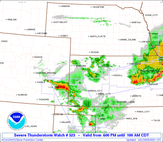
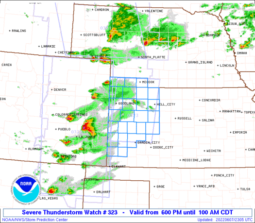
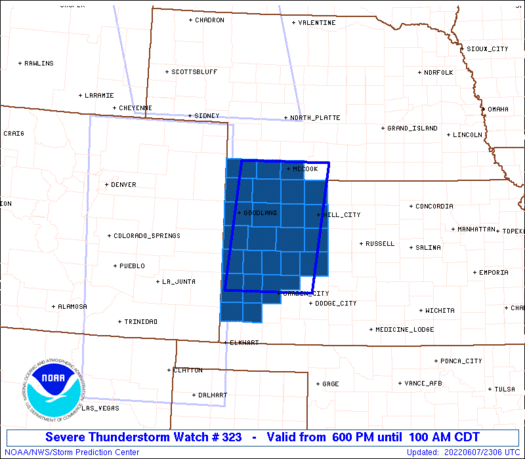
Severe Thunderstorm Watch Number 323
NWS Storm Prediction Center Norman OK
600 PM CDT Tue Jun 7 2022
The NWS Storm Prediction Center has issued a
* Severe Thunderstorm Watch for portions of
Western Kansas
Southwest Nebraska
* Effective this Tuesday night and Wednesday morning from 600 PM
until 100 AM CDT.
* Primary threats include...
Scattered damaging winds and isolated significant gusts to 75
mph likely
Scattered large hail and isolated very large hail events to 2.5
inches in diameter likely
A tornado or two possible
SUMMARY...Intense thunderstorms over eastern Colorado will track
eastward into western Kansas this evening. Very large hail is the
main threat, along with some concern for damaging wind gusts. An
isolated tornado is also possible.
The severe thunderstorm watch area is approximately along and 55
statute miles east and west of a line from 105 miles south southeast
of Goodland KS to 10 miles north northwest of Mccook NE. For a
complete depiction of the watch see the associated watch outline
update (WOUS64 KWNS WOU3).
PRECAUTIONARY/PREPAREDNESS ACTIONS...
REMEMBER...A Severe Thunderstorm Watch means conditions are
favorable for severe thunderstorms in and close to the watch area.
Persons in these areas should be on the lookout for threatening
weather conditions and listen for later statements and possible
warnings. Severe thunderstorms can and occasionally do produce
tornadoes.
&&
OTHER WATCH INFORMATION...CONTINUE...WW 321...WW 322...
AVIATION...A few severe thunderstorms with hail surface and aloft to
2.5 inches. Extreme turbulence and surface wind gusts to 65 knots. A
few cumulonimbi with maximum tops to 500. Mean storm motion vector
27030.
...Hart
   SEL3

   URGENT - IMMEDIATE BROADCAST REQUESTED
   Severe Thunderstorm Watch Number 323
   NWS Storm Prediction Center Norman OK
   600 PM CDT Tue Jun 7 2022

   The NWS Storm Prediction Center has issued a

   * Severe Thunderstorm Watch for portions of
     Western Kansas
     Southwest Nebraska

   * Effective this Tuesday night and Wednesday morning from 600 PM
     until 100 AM CDT.

   * Primary threats include...
     Scattered damaging winds and isolated significant gusts to 75
       mph likely
     Scattered large hail and isolated very large hail events to 2.5
       inches in diameter likely
     A tornado or two possible

   SUMMARY...Intense thunderstorms over eastern Colorado will track
   eastward into western Kansas this evening.  Very large hail is the
   main threat, along with some concern for damaging wind gusts.  An
   isolated tornado is also possible.

   The severe thunderstorm watch area is approximately along and 55
   statute miles east and west of a line from 105 miles south southeast
   of Goodland KS to 10 miles north northwest of Mccook NE. For a
   complete depiction of the watch see the associated watch outline
   update (WOUS64 KWNS WOU3).

   PRECAUTIONARY/PREPAREDNESS ACTIONS...

   REMEMBER...A Severe Thunderstorm Watch means conditions are
   favorable for severe thunderstorms in and close to the watch area.
   Persons in these areas should be on the lookout for threatening
   weather conditions and listen for later statements and possible
   warnings. Severe thunderstorms can and occasionally do produce
   tornadoes.

   &&

   OTHER WATCH INFORMATION...CONTINUE...WW 321...WW 322...

   AVIATION...A few severe thunderstorms with hail surface and aloft to
   2.5 inches. Extreme turbulence and surface wind gusts to 65 knots. A
   few cumulonimbi with maximum tops to 500. Mean storm motion vector
   27030.

   ...Hart
 Note:
The Aviation Watch (SAW) product is an approximation to the watch area.
The actual watch is depicted by the shaded areas.
Note:
The Aviation Watch (SAW) product is an approximation to the watch area.
The actual watch is depicted by the shaded areas.
   SAW3
   WW 323 SEVERE TSTM KS NE 072300Z - 080600Z
   AXIS..55 STATUTE MILES EAST AND WEST OF LINE..
   105SSE GLD/GOODLAND KS/ - 10NNW MCK/MCCOOK NE/
   ..AVIATION COORDS.. 50NM E/W /11W GCK - 9NNW MCK/
   HAIL SURFACE AND ALOFT..2.5 INCHES. WIND GUSTS..65 KNOTS.
   MAX TOPS TO 500. MEAN STORM MOTION VECTOR 27030.

   LAT...LON 37950197 40330170 40339961 37959995

   THIS IS AN APPROXIMATION TO THE WATCH AREA.  FOR A
   COMPLETE DEPICTION OF THE WATCH SEE WOUS64 KWNS
   FOR WOU3.
Watch 323 Status Report Messages:
STATUS REPORT #7 ON WW 323

VALID 080545Z - 080640Z

SEVERE WEATHER THREAT CONTINUES RIGHT OF A LINE FROM 15 E ITR TO
15 SSE HLC.

..BROYLES..06/08/22

ATTN...WFO...GLD...DDC...

&&

STATUS REPORT FOR WS 323

SEVERE WEATHER THREAT CONTINUES FOR THE FOLLOWING AREAS

KSC063-071-109-195-199-203-080640-

KS
.    KANSAS COUNTIES INCLUDED ARE

GOVE		     GREELEY		 LOGAN
TREGO		     WALLACE		 WICHITA
$$


THE WATCH STATUS MESSAGE IS FOR GUIDANCE PURPOSES ONLY.  PLEASE
REFER TO WATCH COUNTY NOTIFICATION STATEMENTS FOR OFFICIAL
INFORMATION ON COUNTIES...INDEPENDENT CITIES AND MARINE ZONES
CLEARED FROM SEVERE THUNDERSTORM AND TORNADO WATCHES.
$$

STATUS REPORT #6 ON WW 323

VALID 080445Z - 080540Z

THE SEVERE WEATHER THREAT CONTINUES ACROSS THE ENTIRE WATCH AREA.

..SPC..06/08/22

ATTN...WFO...GLD...DDC...

&&

STATUS REPORT FOR WS 323

SEVERE WEATHER THREAT CONTINUES FOR THE FOLLOWING AREAS

KSC023-039-063-065-071-109-137-153-179-181-193-195-199-203-
080540-

KS
.    KANSAS COUNTIES INCLUDED ARE

CHEYENNE	     DECATUR		 GOVE
GRAHAM		     GREELEY		 LOGAN
NORTON		     RAWLINS		 SHERIDAN
SHERMAN 	     THOMAS		 TREGO
WALLACE 	     WICHITA
$$


NEC057-087-145-080540-

NE
.    NEBRASKA COUNTIES INCLUDED ARE

DUNDY		     HITCHCOCK		 RED WILLOW
$$


THE WATCH STATUS MESSAGE IS FOR GUIDANCE PURPOSES ONLY.  PLEASE
REFER TO WATCH COUNTY NOTIFICATION STATEMENTS FOR OFFICIAL
INFORMATION ON COUNTIES...INDEPENDENT CITIES AND MARINE ZONES
CLEARED FROM SEVERE THUNDERSTORM AND TORNADO WATCHES.
$$

STATUS REPORT #5 ON WW 323

VALID 080345Z - 080440Z

THE SEVERE WEATHER THREAT CONTINUES ACROSS THE ENTIRE WATCH AREA.

..SPC..06/08/22

ATTN...WFO...GLD...DDC...

&&

STATUS REPORT FOR WS 323

SEVERE WEATHER THREAT CONTINUES FOR THE FOLLOWING AREAS

KSC023-039-055-063-065-067-071-075-093-101-109-135-137-153-171-
179-181-187-193-195-199-203-080440-

KS
.    KANSAS COUNTIES INCLUDED ARE

CHEYENNE	     DECATUR		 FINNEY
GOVE		     GRAHAM		 GRANT
GREELEY 	     HAMILTON		 KEARNY
LANE		     LOGAN		 NESS
NORTON		     RAWLINS		 SCOTT
SHERIDAN	     SHERMAN		 STANTON
THOMAS		     TREGO		 WALLACE
WICHITA
$$


NEC057-087-145-080440-

NE
.    NEBRASKA COUNTIES INCLUDED ARE

DUNDY		     HITCHCOCK		 RED WILLOW
$$


THE WATCH STATUS MESSAGE IS FOR GUIDANCE PURPOSES ONLY.  PLEASE
REFER TO WATCH COUNTY NOTIFICATION STATEMENTS FOR OFFICIAL
INFORMATION ON COUNTIES...INDEPENDENT CITIES AND MARINE ZONES
CLEARED FROM SEVERE THUNDERSTORM AND TORNADO WATCHES.
$$

STATUS REPORT #4 ON WW 323

VALID 080245Z - 080340Z

THE SEVERE WEATHER THREAT CONTINUES ACROSS THE ENTIRE WATCH AREA.

..WEINMAN..06/08/22

ATTN...WFO...GLD...DDC...

&&

STATUS REPORT FOR WS 323

SEVERE WEATHER THREAT CONTINUES FOR THE FOLLOWING AREAS

KSC023-039-055-063-065-067-071-075-093-101-109-135-137-153-171-
179-181-187-193-195-199-203-080340-

KS
.    KANSAS COUNTIES INCLUDED ARE

CHEYENNE	     DECATUR		 FINNEY
GOVE		     GRAHAM		 GRANT
GREELEY 	     HAMILTON		 KEARNY
LANE		     LOGAN		 NESS
NORTON		     RAWLINS		 SCOTT
SHERIDAN	     SHERMAN		 STANTON
THOMAS		     TREGO		 WALLACE
WICHITA
$$


NEC057-087-145-080340-

NE
.    NEBRASKA COUNTIES INCLUDED ARE

DUNDY		     HITCHCOCK		 RED WILLOW
$$


THE WATCH STATUS MESSAGE IS FOR GUIDANCE PURPOSES ONLY.  PLEASE
REFER TO WATCH COUNTY NOTIFICATION STATEMENTS FOR OFFICIAL
INFORMATION ON COUNTIES...INDEPENDENT CITIES AND MARINE ZONES
CLEARED FROM SEVERE THUNDERSTORM AND TORNADO WATCHES.
$$

STATUS REPORT #3 ON WW 323

VALID 080145Z - 080240Z

THE SEVERE WEATHER THREAT CONTINUES ACROSS THE ENTIRE WATCH AREA.

..WEINMAN..06/08/22

ATTN...WFO...GLD...DDC...

&&

STATUS REPORT FOR WS 323

SEVERE WEATHER THREAT CONTINUES FOR THE FOLLOWING AREAS

KSC023-039-055-063-065-067-071-075-093-101-109-135-137-153-171-
179-181-187-193-195-199-203-080240-

KS
.    KANSAS COUNTIES INCLUDED ARE

CHEYENNE	     DECATUR		 FINNEY
GOVE		     GRAHAM		 GRANT
GREELEY 	     HAMILTON		 KEARNY
LANE		     LOGAN		 NESS
NORTON		     RAWLINS		 SCOTT
SHERIDAN	     SHERMAN		 STANTON
THOMAS		     TREGO		 WALLACE
WICHITA
$$


NEC057-087-145-080240-

NE
.    NEBRASKA COUNTIES INCLUDED ARE

DUNDY		     HITCHCOCK		 RED WILLOW
$$


THE WATCH STATUS MESSAGE IS FOR GUIDANCE PURPOSES ONLY.  PLEASE
REFER TO WATCH COUNTY NOTIFICATION STATEMENTS FOR OFFICIAL
INFORMATION ON COUNTIES...INDEPENDENT CITIES AND MARINE ZONES
CLEARED FROM SEVERE THUNDERSTORM AND TORNADO WATCHES.
$$

STATUS REPORT #2 ON WW 323

VALID 080040Z - 080140Z

THE SEVERE WEATHER THREAT CONTINUES ACROSS THE ENTIRE WATCH AREA.

FOR ADDITIONAL INFORMATION SEE MESOSCALE DISCUSSION 1078

..WENDT..06/08/22

ATTN...WFO...GLD...DDC...

&&

STATUS REPORT FOR WS 323

SEVERE WEATHER THREAT CONTINUES FOR THE FOLLOWING AREAS

KSC023-039-055-063-065-067-071-075-093-101-109-135-137-153-171-
179-181-187-193-195-199-203-080140-

KS
.    KANSAS COUNTIES INCLUDED ARE

CHEYENNE	     DECATUR		 FINNEY
GOVE		     GRAHAM		 GRANT
GREELEY 	     HAMILTON		 KEARNY
LANE		     LOGAN		 NESS
NORTON		     RAWLINS		 SCOTT
SHERIDAN	     SHERMAN		 STANTON
THOMAS		     TREGO		 WALLACE
WICHITA
$$


NEC057-087-145-080140-

NE
.    NEBRASKA COUNTIES INCLUDED ARE

DUNDY		     HITCHCOCK		 RED WILLOW
$$


THE WATCH STATUS MESSAGE IS FOR GUIDANCE PURPOSES ONLY.  PLEASE
REFER TO WATCH COUNTY NOTIFICATION STATEMENTS FOR OFFICIAL
INFORMATION ON COUNTIES...INDEPENDENT CITIES AND MARINE ZONES
CLEARED FROM SEVERE THUNDERSTORM AND TORNADO WATCHES.
$$

STATUS REPORT #1 ON WW 323

VALID 072350Z - 080040Z

THE SEVERE WEATHER THREAT CONTINUES ACROSS THE ENTIRE WATCH AREA.

..WENDT..06/07/22

ATTN...WFO...GLD...DDC...

&&

STATUS REPORT FOR WS 323

SEVERE WEATHER THREAT CONTINUES FOR THE FOLLOWING AREAS

KSC023-039-055-063-065-067-071-075-093-101-109-135-137-153-171-
179-181-187-193-195-199-203-080040-

KS
.    KANSAS COUNTIES INCLUDED ARE

CHEYENNE	     DECATUR		 FINNEY
GOVE		     GRAHAM		 GRANT
GREELEY 	     HAMILTON		 KEARNY
LANE		     LOGAN		 NESS
NORTON		     RAWLINS		 SCOTT
SHERIDAN	     SHERMAN		 STANTON
THOMAS		     TREGO		 WALLACE
WICHITA
$$


NEC057-087-145-080040-

NE
.    NEBRASKA COUNTIES INCLUDED ARE

DUNDY		     HITCHCOCK		 RED WILLOW
$$


THE WATCH STATUS MESSAGE IS FOR GUIDANCE PURPOSES ONLY.  PLEASE
REFER TO WATCH COUNTY NOTIFICATION STATEMENTS FOR OFFICIAL
INFORMATION ON COUNTIES...INDEPENDENT CITIES AND MARINE ZONES
CLEARED FROM SEVERE THUNDERSTORM AND TORNADO WATCHES.
$$
Note:
Click for Complete Product Text.
Tornadoes
Probability of 2 or more tornadoes
|
Low (20%)
|
Probability of 1 or more strong (EF2-EF5) tornadoes
|
Low (5%)
|
Wind
Probability of 10 or more severe wind events
|
Mod (60%)
|
Probability of 1 or more wind events > 65 knots
|
Mod (60%)
|
Hail
Probability of 10 or more severe hail events
|
High (70%)
|
Probability of 1 or more hailstones > 2 inches
|
Mod (60%)
|
Combined Severe Hail/Wind
Probability of 6 or more combined severe hail/wind events
|
High (>95%)
|
For each watch, probabilities for particular events inside the watch
(listed above in each table) are determined by the issuing forecaster.
The "Low" category contains probability values ranging from less than 2%
to 20% (EF2-EF5 tornadoes), less than 5% to 20% (all other probabilities),
"Moderate" from 30% to 60%, and "High" from 70% to greater than 95%.
High values are bolded and lighter in color to provide awareness of
an increased threat for a particular event.


 @NWSSPC


