 Note:
The expiration time in the watch graphic is amended if the watch is
replaced, cancelled or extended.
Note:
Note:
The expiration time in the watch graphic is amended if the watch is
replaced, cancelled or extended.
Note: Click for
Watch Status Reports.
SEL4
URGENT - IMMEDIATE BROADCAST REQUESTED
Severe Thunderstorm Watch Number 474
NWS Storm Prediction Center Norman OK
1245 PM MDT Mon Jul 18 2022
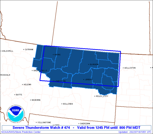
The NWS Storm Prediction Center has issued a
* Severe Thunderstorm Watch for portions of
Central and Eastern Montana
* Effective this Monday afternoon and evening from 1245 PM until
800 PM MDT.
* Primary threats include...
Scattered large hail and isolated very large hail events to 2.5
inches in diameter likely
Scattered damaging winds likely with isolated significant gusts
to 80 mph possible
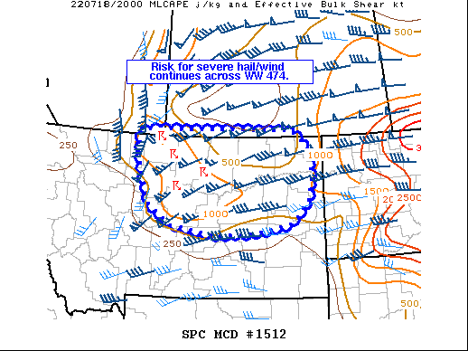
SUMMARY...Thunderstorms will rapidly intensify this afternoon over
north-central Montana and track quickly eastward across the watch
area. Significant damaging wind gusts and large hail will be
possible in the stronger storms.
The severe thunderstorm watch area is approximately along and 70
statute miles north and south of a line from 55 miles southwest of
Havre MT to 30 miles north northeast of Sidney MT. For a complete
depiction of the watch see the associated watch outline update
(WOUS64 KWNS WOU4).
PRECAUTIONARY/PREPAREDNESS ACTIONS...
REMEMBER...A Severe Thunderstorm Watch means conditions are
favorable for severe thunderstorms in and close to the watch area.
Persons in these areas should be on the lookout for threatening
weather conditions and listen for later statements and possible
warnings. Severe thunderstorms can and occasionally do produce
tornadoes.
&&
OTHER WATCH INFORMATION...CONTINUE...WW 473...
AVIATION...A few severe thunderstorms with hail surface and aloft to
2.5 inches. Extreme turbulence and surface wind gusts to 70 knots. A
few cumulonimbi with maximum tops to 500. Mean storm motion vector
25040.
...Hart
 Note:
The Aviation Watch (SAW) product is an approximation to the watch area.
The actual watch is depicted by the shaded areas.
Note:
The Aviation Watch (SAW) product is an approximation to the watch area.
The actual watch is depicted by the shaded areas.
   SAW4
   WW 474 SEVERE TSTM MT 181845Z - 190200Z
   AXIS..70 STATUTE MILES NORTH AND SOUTH OF LINE..
   55SW HVR/HAVRE MT/ - 30NNE SDY/SIDNEY MT/
   ..AVIATION COORDS.. 60NM N/S /46NE GTF - 14WSW ISN/
   HAIL SURFACE AND ALOFT..2.5 INCHES. WIND GUSTS..70 KNOTS.
   MAX TOPS TO 500. MEAN STORM MOTION VECTOR 25040.

   LAT...LON 49001061 49110395 47090395 46971061

   THIS IS AN APPROXIMATION TO THE WATCH AREA.  FOR A
   COMPLETE DEPICTION OF THE WATCH SEE WOUS64 KWNS
   FOR WOU4.
Watch 474 Status Report Messages:
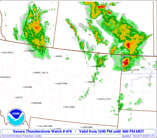
STATUS REPORT #4 ON WW 474

VALID 190010Z - 190140Z

SEVERE WEATHER THREAT CONTINUES RIGHT OF A LINE FROM 80 WNW MLS
TO 45 S GGW TO 20 SE GGW TO 25 ENE GGW TO 40 NNE GGW TO 70 N GGW.

..JEWELL..07/19/22

ATTN...WFO...TFX...GGW...

&&

STATUS REPORT FOR WS 474

SEVERE WEATHER THREAT CONTINUES FOR THE FOLLOWING AREAS

MTC019-021-033-055-079-083-085-091-105-109-190140-

MT
.    MONTANA COUNTIES INCLUDED ARE

DANIELS 	     DAWSON		 GARFIELD
MCCONE		     PRAIRIE		 RICHLAND
ROOSEVELT	     SHERIDAN		 VALLEY
WIBAUX
$$


THE WATCH STATUS MESSAGE IS FOR GUIDANCE PURPOSES ONLY.  PLEASE
REFER TO WATCH COUNTY NOTIFICATION STATEMENTS FOR OFFICIAL
INFORMATION ON COUNTIES...INDEPENDENT CITIES AND MARINE ZONES
CLEARED FROM SEVERE THUNDERSTORM AND TORNADO WATCHES.
$$

STATUS REPORT #3 ON WW 474

VALID 182210Z - 182340Z

SEVERE WEATHER THREAT CONTINUES RIGHT OF A LINE FROM 45 SE LWT TO
60 NE LWT TO 75 ESE HVR TO 65 E HVR TO 80 ENE HVR.

..JEWELL..07/18/22

ATTN...WFO...TFX...GGW...

&&

STATUS REPORT FOR WS 474

SEVERE WEATHER THREAT CONTINUES FOR THE FOLLOWING AREAS

MTC019-021-033-055-069-071-079-083-085-091-105-109-182340-

MT
.    MONTANA COUNTIES INCLUDED ARE

DANIELS 	     DAWSON		 GARFIELD
MCCONE		     PETROLEUM		 PHILLIPS
PRAIRIE 	     RICHLAND		 ROOSEVELT
SHERIDAN	     VALLEY		 WIBAUX
$$


THE WATCH STATUS MESSAGE IS FOR GUIDANCE PURPOSES ONLY.  PLEASE
REFER TO WATCH COUNTY NOTIFICATION STATEMENTS FOR OFFICIAL
INFORMATION ON COUNTIES...INDEPENDENT CITIES AND MARINE ZONES
CLEARED FROM SEVERE THUNDERSTORM AND TORNADO WATCHES.
$$

STATUS REPORT #2 ON WW 474

VALID 182040Z - 182140Z

THE SEVERE WEATHER THREAT CONTINUES ACROSS THE ENTIRE WATCH AREA.

FOR ADDITIONAL INFORMATION SEE MESOSCALE DISCUSSION 1512

..MOORE..07/18/22

ATTN...WFO...TFX...GGW...

&&

STATUS REPORT FOR WS 474

SEVERE WEATHER THREAT CONTINUES FOR THE FOLLOWING AREAS

MTC005-015-019-021-027-033-041-051-055-069-071-079-083-085-091-
105-109-182140-

MT
.    MONTANA COUNTIES INCLUDED ARE

BLAINE		     CHOUTEAU		 DANIELS
DAWSON		     FERGUS		 GARFIELD
HILL		     LIBERTY		 MCCONE
PETROLEUM	     PHILLIPS		 PRAIRIE
RICHLAND	     ROOSEVELT		 SHERIDAN
VALLEY		     WIBAUX
$$


THE WATCH STATUS MESSAGE IS FOR GUIDANCE PURPOSES ONLY.  PLEASE
REFER TO WATCH COUNTY NOTIFICATION STATEMENTS FOR OFFICIAL
INFORMATION ON COUNTIES...INDEPENDENT CITIES AND MARINE ZONES
CLEARED FROM SEVERE THUNDERSTORM AND TORNADO WATCHES.
$$

STATUS REPORT #1 ON WW 474

VALID 181945Z - 182040Z

THE SEVERE WEATHER THREAT CONTINUES ACROSS THE ENTIRE WATCH AREA.

..MOORE..07/18/22

ATTN...WFO...TFX...GGW...

&&

STATUS REPORT FOR WS 474

SEVERE WEATHER THREAT CONTINUES FOR THE FOLLOWING AREAS

MTC005-015-019-021-027-033-041-051-055-069-071-079-083-085-091-
105-109-182040-

MT
.    MONTANA COUNTIES INCLUDED ARE

BLAINE		     CHOUTEAU		 DANIELS
DAWSON		     FERGUS		 GARFIELD
HILL		     LIBERTY		 MCCONE
PETROLEUM	     PHILLIPS		 PRAIRIE
RICHLAND	     ROOSEVELT		 SHERIDAN
VALLEY		     WIBAUX
$$


THE WATCH STATUS MESSAGE IS FOR GUIDANCE PURPOSES ONLY.  PLEASE
REFER TO WATCH COUNTY NOTIFICATION STATEMENTS FOR OFFICIAL
INFORMATION ON COUNTIES...INDEPENDENT CITIES AND MARINE ZONES
CLEARED FROM SEVERE THUNDERSTORM AND TORNADO WATCHES.
$$
Note:
Click for Complete Product Text.
Tornadoes
Probability of 2 or more tornadoes
|
Low (10%)
|
Probability of 1 or more strong (EF2-EF5) tornadoes
|
Low (<2%)
|
Wind
Probability of 10 or more severe wind events
|
Mod (60%)
|
Probability of 1 or more wind events > 65 knots
|
Mod (40%)
|
Hail
Probability of 10 or more severe hail events
|
High (70%)
|
Probability of 1 or more hailstones > 2 inches
|
Mod (60%)
|
Combined Severe Hail/Wind
Probability of 6 or more combined severe hail/wind events
|
High (>95%)
|
For each watch, probabilities for particular events inside the watch
(listed above in each table) are determined by the issuing forecaster.
The "Low" category contains probability values ranging from less than 2%
to 20% (EF2-EF5 tornadoes), less than 5% to 20% (all other probabilities),
"Moderate" from 30% to 60%, and "High" from 70% to greater than 95%.
High values are bolded and lighter in color to provide awareness of
an increased threat for a particular event.


 @NWSSPC