 Note:
The expiration time in the watch graphic is amended if the watch is
replaced, cancelled or extended.
Note:
Note:
The expiration time in the watch graphic is amended if the watch is
replaced, cancelled or extended.
Note: Click for
Watch Status Reports.
SEL5
URGENT - IMMEDIATE BROADCAST REQUESTED
Severe Thunderstorm Watch Number 525
NWS Storm Prediction Center Norman OK
440 PM CDT Sun Aug 28 2022
The NWS Storm Prediction Center has issued a
* Severe Thunderstorm Watch for portions of
Northern Minnesota
* Effective this Sunday afternoon and evening from 440 PM until
1100 PM CDT.
* Primary threats include...
Scattered damaging winds and isolated significant gusts to 75
mph possible
Scattered large hail and isolated very large hail events to 2
inches in diameter possible
A tornado or two possible
SUMMARY...Initial thunderstorm cluster across northwest Minnesota
should spread east this evening, while additional semi-discrete
supercells may develop south of it and merge into a broadening
cluster towards northeast Minnesota towards late evening.
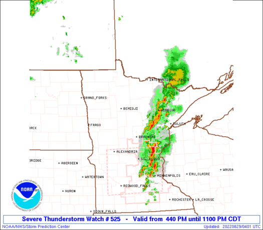
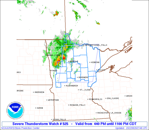
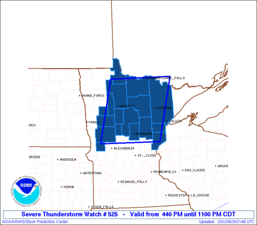
The severe thunderstorm watch area is approximately along and 80
statute miles east and west of a line from 25 miles south southwest
of Brainerd MN to 90 miles north northwest of Hibbing MN. For a
complete depiction of the watch see the associated watch outline
update (WOUS64 KWNS WOU5).
PRECAUTIONARY/PREPAREDNESS ACTIONS...
REMEMBER...A Severe Thunderstorm Watch means conditions are
favorable for severe thunderstorms in and close to the watch area.
Persons in these areas should be on the lookout for threatening
weather conditions and listen for later statements and possible
warnings. Severe thunderstorms can and occasionally do produce
tornadoes.
&&
OTHER WATCH INFORMATION...CONTINUE...WW 524...
AVIATION...A few severe thunderstorms with hail surface and aloft to
2 inches. Extreme turbulence and surface wind gusts to 65 knots. A
few cumulonimbi with maximum tops to 500. Mean storm motion vector
24030.
...Grams
   SEL5

   URGENT - IMMEDIATE BROADCAST REQUESTED
   Severe Thunderstorm Watch Number 525
   NWS Storm Prediction Center Norman OK
   440 PM CDT Sun Aug 28 2022

   The NWS Storm Prediction Center has issued a

   * Severe Thunderstorm Watch for portions of
     Northern Minnesota

   * Effective this Sunday afternoon and evening from 440 PM until
     1100 PM CDT.

   * Primary threats include...
     Scattered damaging winds and isolated significant gusts to 75
       mph possible
     Scattered large hail and isolated very large hail events to 2
       inches in diameter possible
     A tornado or two possible

   SUMMARY...Initial thunderstorm cluster across northwest Minnesota
   should spread east this evening, while additional semi-discrete
   supercells may develop south of it and merge into a broadening
   cluster towards northeast Minnesota towards late evening.

   The severe thunderstorm watch area is approximately along and 80
   statute miles east and west of a line from 25 miles south southwest
   of Brainerd MN to 90 miles north northwest of Hibbing MN. For a
   complete depiction of the watch see the associated watch outline
   update (WOUS64 KWNS WOU5).

   PRECAUTIONARY/PREPAREDNESS ACTIONS...

   REMEMBER...A Severe Thunderstorm Watch means conditions are
   favorable for severe thunderstorms in and close to the watch area.
   Persons in these areas should be on the lookout for threatening
   weather conditions and listen for later statements and possible
   warnings. Severe thunderstorms can and occasionally do produce
   tornadoes.

   &&

   OTHER WATCH INFORMATION...CONTINUE...WW 524...

   AVIATION...A few severe thunderstorms with hail surface and aloft to
   2 inches. Extreme turbulence and surface wind gusts to 65 knots. A
   few cumulonimbi with maximum tops to 500. Mean storm motion vector
   24030.

   ...Grams
 Note:
The Aviation Watch (SAW) product is an approximation to the watch area.
The actual watch is depicted by the shaded areas.
Note:
The Aviation Watch (SAW) product is an approximation to the watch area.
The actual watch is depicted by the shaded areas.
   SAW5
   WW 525 SEVERE TSTM MN 282140Z - 290400Z
   AXIS..80 STATUTE MILES EAST AND WEST OF LINE..
   25SSW BRD/BRAINERD MN/ - 90NNW HIB/HIBBING MN/
   ..AVIATION COORDS.. 70NM E/W /21SW BRD - 7W INL/
   HAIL SURFACE AND ALOFT..2 INCHES. WIND GUSTS..65 KNOTS.
   MAX TOPS TO 500. MEAN STORM MOTION VECTOR 24030.

   LAT...LON 46059600 48579533 48579183 46059266

   THIS IS AN APPROXIMATION TO THE WATCH AREA.  FOR A
   COMPLETE DEPICTION OF THE WATCH SEE WOUS64 KWNS
   FOR WOU5.
Watch 525 Status Report Messages:
STATUS REPORT #6 ON WW 525

VALID 290320Z - 290400Z

SEVERE WEATHER THREAT CONTINUES RIGHT OF A LINE FROM 25 SSW BRD
TO 40 E INL.

PARTS OF REMAINING VALID PORTION OF WW COULD BE LOCALLY EXTENDED
AN HOUR OT SO.	OTHERWISE, A NEW WW IS NOT ANTICIPATED.

..KERR..08/29/22

ATTN...WFO...DLH...FGF...

&&

STATUS REPORT FOR WS 525

SEVERE WEATHER THREAT CONTINUES FOR THE FOLLOWING AREAS

MNC001-017-035-115-137-290400-

MN
.    MINNESOTA COUNTIES INCLUDED ARE

AITKIN		     CARLTON		 CROW WING
PINE		     ST. LOUIS
$$


THE WATCH STATUS MESSAGE IS FOR GUIDANCE PURPOSES ONLY.  PLEASE
REFER TO WATCH COUNTY NOTIFICATION STATEMENTS FOR OFFICIAL
INFORMATION ON COUNTIES...INDEPENDENT CITIES AND MARINE ZONES
CLEARED FROM SEVERE THUNDERSTORM AND TORNADO WATCHES.
$$

STATUS REPORT #5 ON WW 525

VALID 290250Z - 290340Z

SEVERE WEATHER THREAT CONTINUES RIGHT OF A LINE FROM 20 SSW BRD
TO 5 W INL.

..KERR..08/29/22

ATTN...WFO...DLH...FGF...

&&

STATUS REPORT FOR WS 525

SEVERE WEATHER THREAT CONTINUES FOR THE FOLLOWING AREAS

MNC001-017-035-061-115-137-290340-

MN
.    MINNESOTA COUNTIES INCLUDED ARE

AITKIN		     CARLTON		 CROW WING
ITASCA		     PINE		 ST. LOUIS
$$


THE WATCH STATUS MESSAGE IS FOR GUIDANCE PURPOSES ONLY.  PLEASE
REFER TO WATCH COUNTY NOTIFICATION STATEMENTS FOR OFFICIAL
INFORMATION ON COUNTIES...INDEPENDENT CITIES AND MARINE ZONES
CLEARED FROM SEVERE THUNDERSTORM AND TORNADO WATCHES.
$$

STATUS REPORT #4 ON WW 525

VALID 290130Z - 290240Z

SEVERE WEATHER THREAT CONTINUES RIGHT OF A LINE FROM 30 ENE AXN
TO 40 W INL.

..KERR..08/29/22

ATTN...WFO...DLH...FGF...

&&

STATUS REPORT FOR WS 525

SEVERE WEATHER THREAT CONTINUES FOR THE FOLLOWING AREAS

MNC001-017-021-035-061-071-115-137-290240-

MN
.    MINNESOTA COUNTIES INCLUDED ARE

AITKIN		     CARLTON		 CASS
CROW WING	     ITASCA		 KOOCHICHING
PINE		     ST. LOUIS
$$


THE WATCH STATUS MESSAGE IS FOR GUIDANCE PURPOSES ONLY.  PLEASE
REFER TO WATCH COUNTY NOTIFICATION STATEMENTS FOR OFFICIAL
INFORMATION ON COUNTIES...INDEPENDENT CITIES AND MARINE ZONES
CLEARED FROM SEVERE THUNDERSTORM AND TORNADO WATCHES.
$$

STATUS REPORT #3 ON WW 525

VALID 290055Z - 290140Z

SEVERE WEATHER THREAT CONTINUES RIGHT OF A LINE FROM 25 NW AXN TO
20 E DTL TO 20 SW BJI TO 20 SSE ROX.

..LYONS..08/29/22

ATTN...WFO...DLH...FGF...

&&

STATUS REPORT FOR WS 525

SEVERE WEATHER THREAT CONTINUES FOR THE FOLLOWING AREAS

MNC001-007-017-021-029-035-057-061-071-077-111-115-137-159-
290140-

MN
.    MINNESOTA COUNTIES INCLUDED ARE

AITKIN		     BELTRAMI		 CARLTON
CASS		     CLEARWATER 	 CROW WING
HUBBARD 	     ITASCA		 KOOCHICHING
LAKE OF THE WOODS    OTTER TAIL 	 PINE
ST. LOUIS	     WADENA
$$


THE WATCH STATUS MESSAGE IS FOR GUIDANCE PURPOSES ONLY.  PLEASE
REFER TO WATCH COUNTY NOTIFICATION STATEMENTS FOR OFFICIAL
INFORMATION ON COUNTIES...INDEPENDENT CITIES AND MARINE ZONES
CLEARED FROM SEVERE THUNDERSTORM AND TORNADO WATCHES.
$$

STATUS REPORT #2 ON WW 525

VALID 290000Z - 290140Z

SEVERE WEATHER THREAT CONTINUES RIGHT OF A LINE FROM 25 NW AXN TO
30 NW DTL.

FOR ADDITIONAL INFORMATION SEE MESOSCALE DISCUSSION 1735

..LYONS..08/28/22

ATTN...WFO...DLH...FGF...

&&

STATUS REPORT FOR WS 525

SEVERE WEATHER THREAT CONTINUES FOR THE FOLLOWING AREAS

MNC001-005-007-017-021-029-035-057-061-071-077-087-111-115-137-
159-290140-

MN
.    MINNESOTA COUNTIES INCLUDED ARE

AITKIN		     BECKER		 BELTRAMI
CARLTON 	     CASS		 CLEARWATER
CROW WING	     HUBBARD		 ITASCA
KOOCHICHING	     LAKE OF THE WOODS	 MAHNOMEN
OTTER TAIL	     PINE		 ST. LOUIS
WADENA
$$


THE WATCH STATUS MESSAGE IS FOR GUIDANCE PURPOSES ONLY.  PLEASE
REFER TO WATCH COUNTY NOTIFICATION STATEMENTS FOR OFFICIAL
INFORMATION ON COUNTIES...INDEPENDENT CITIES AND MARINE ZONES
CLEARED FROM SEVERE THUNDERSTORM AND TORNADO WATCHES.
$$

STATUS REPORT #1 ON WW 525

VALID 282255Z - 282340Z

THE SEVERE WEATHER THREAT CONTINUES ACROSS THE ENTIRE WATCH AREA.

..LYONS..08/28/22

ATTN...WFO...DLH...FGF...

&&

STATUS REPORT FOR WS 525

SEVERE WEATHER THREAT CONTINUES FOR THE FOLLOWING AREAS

MNC001-005-007-017-021-029-035-051-057-061-071-077-087-111-115-
137-159-282340-

MN
.    MINNESOTA COUNTIES INCLUDED ARE

AITKIN		     BECKER		 BELTRAMI
CARLTON 	     CASS		 CLEARWATER
CROW WING	     GRANT		 HUBBARD
ITASCA		     KOOCHICHING	 LAKE OF THE WOODS
MAHNOMEN	     OTTER TAIL 	 PINE
ST. LOUIS	     WADENA
$$


THE WATCH STATUS MESSAGE IS FOR GUIDANCE PURPOSES ONLY.  PLEASE
REFER TO WATCH COUNTY NOTIFICATION STATEMENTS FOR OFFICIAL
INFORMATION ON COUNTIES...INDEPENDENT CITIES AND MARINE ZONES
CLEARED FROM SEVERE THUNDERSTORM AND TORNADO WATCHES.
$$
Note:
Click for Complete Product Text.
Tornadoes
Probability of 2 or more tornadoes
|
Low (20%)
|
Probability of 1 or more strong (EF2-EF5) tornadoes
|
Low (10%)
|
Wind
Probability of 10 or more severe wind events
|
Mod (50%)
|
Probability of 1 or more wind events > 65 knots
|
Mod (30%)
|
Hail
Probability of 10 or more severe hail events
|
Mod (40%)
|
Probability of 1 or more hailstones > 2 inches
|
Mod (40%)
|
Combined Severe Hail/Wind
Probability of 6 or more combined severe hail/wind events
|
High (80%)
|
For each watch, probabilities for particular events inside the watch
(listed above in each table) are determined by the issuing forecaster.
The "Low" category contains probability values ranging from less than 2%
to 20% (EF2-EF5 tornadoes), less than 5% to 20% (all other probabilities),
"Moderate" from 30% to 60%, and "High" from 70% to greater than 95%.
High values are bolded and lighter in color to provide awareness of
an increased threat for a particular event.


 @NWSSPC


