 Note:
The expiration time in the watch graphic is amended if the watch is
replaced, cancelled or extended.
Note:
Note:
The expiration time in the watch graphic is amended if the watch is
replaced, cancelled or extended.
Note: Click for
Watch Status Reports.
SEL6
URGENT - IMMEDIATE BROADCAST REQUESTED
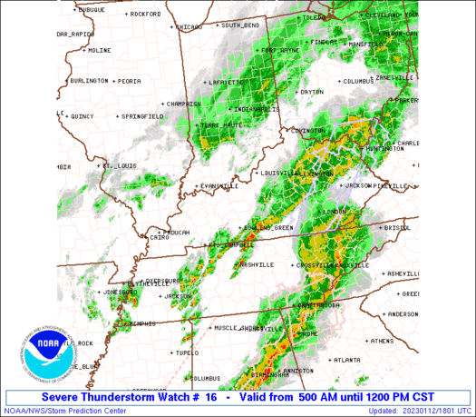
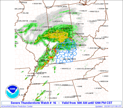
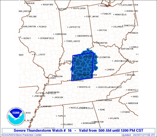
Severe Thunderstorm Watch Number 16
NWS Storm Prediction Center Norman OK
500 AM CST Thu Jan 12 2023
The NWS Storm Prediction Center has issued a
* Severe Thunderstorm Watch for portions of
Extreme southern Indiana
Central Kentucky
* Effective this Thursday morning from 500 AM until NOON CST.
* Primary threats include...
Scattered damaging wind gusts to 70 mph possible
Scattered large hail events to 1.5 inches in diameter possible
A tornado or two possible
SUMMARY...Clusters of storms with bowing and supercell structures
will persist through the morning and spread into central Kentucky.
The storm environment will support the threat for damaging winds of
60-70 mph, hail up to 1.5 inches in diameter, and possibly an
isolated tornado or two.
The severe thunderstorm watch area is approximately along and 50
statute miles east and west of a line from 25 miles south southeast
of Bowling Green KY to 15 miles north northwest of Louisville KY.
For a complete depiction of the watch see the associated watch
outline update (WOUS64 KWNS WOU6).
PRECAUTIONARY/PREPAREDNESS ACTIONS...
REMEMBER...A Severe Thunderstorm Watch means conditions are
favorable for severe thunderstorms in and close to the watch area.
Persons in these areas should be on the lookout for threatening
weather conditions and listen for later statements and possible
warnings. Severe thunderstorms can and occasionally do produce
tornadoes.
&&
OTHER WATCH INFORMATION...CONTINUE...WW 15...
AVIATION...A few severe thunderstorms with hail surface and aloft to
1.5 inches. Extreme turbulence and surface wind gusts to 60 knots. A
few cumulonimbi with maximum tops to 450. Mean storm motion vector
24050.
...Thompson
   SEL6

   URGENT - IMMEDIATE BROADCAST REQUESTED
   Severe Thunderstorm Watch Number 16
   NWS Storm Prediction Center Norman OK
   500 AM CST Thu Jan 12 2023

   The NWS Storm Prediction Center has issued a

   * Severe Thunderstorm Watch for portions of
     Extreme southern Indiana
     Central Kentucky

   * Effective this Thursday morning from 500 AM until NOON CST.

   * Primary threats include...
     Scattered damaging wind gusts to 70 mph possible
     Scattered large hail events to 1.5 inches in diameter possible
     A tornado or two possible

   SUMMARY...Clusters of storms with bowing and supercell structures
   will persist through the morning and spread into central Kentucky.
   The storm environment will support the threat for damaging winds of
   60-70 mph, hail up to 1.5 inches in diameter, and possibly an
   isolated tornado or two.

   The severe thunderstorm watch area is approximately along and 50
   statute miles east and west of a line from 25 miles south southeast
   of Bowling Green KY to 15 miles north northwest of Louisville KY.
   For a complete depiction of the watch see the associated watch
   outline update (WOUS64 KWNS WOU6).

   PRECAUTIONARY/PREPAREDNESS ACTIONS...

   REMEMBER...A Severe Thunderstorm Watch means conditions are
   favorable for severe thunderstorms in and close to the watch area.
   Persons in these areas should be on the lookout for threatening
   weather conditions and listen for later statements and possible
   warnings. Severe thunderstorms can and occasionally do produce
   tornadoes.

   &&

   OTHER WATCH INFORMATION...CONTINUE...WW 15...

   AVIATION...A few severe thunderstorms with hail surface and aloft to
   1.5 inches. Extreme turbulence and surface wind gusts to 60 knots. A
   few cumulonimbi with maximum tops to 450. Mean storm motion vector
   24050.

   ...Thompson
 Note:
The Aviation Watch (SAW) product is an approximation to the watch area.
The actual watch is depicted by the shaded areas.
Note:
The Aviation Watch (SAW) product is an approximation to the watch area.
The actual watch is depicted by the shaded areas.
   SAW6
   WW 16 SEVERE TSTM IN KY 121100Z - 121800Z
   AXIS..50 STATUTE MILES EAST AND WEST OF LINE..
   25SSE BWG/BOWLING GREEN KY/ - 15NNW SDF/LOUISVILLE KY/
   ..AVIATION COORDS.. 45NM E/W /20SSE BWG - 21NW IIU/
   HAIL SURFACE AND ALOFT..1.5 INCHES. WIND GUSTS..60 KNOTS.
   MAX TOPS TO 450. MEAN STORM MOTION VECTOR 24050.

   LAT...LON 36638715 38388676 38388491 36638535

   THIS IS AN APPROXIMATION TO THE WATCH AREA.  FOR A
   COMPLETE DEPICTION OF THE WATCH SEE WOUS64 KWNS
   FOR WOU6.
Watch 16 Status Report Messages:
STATUS REPORT #3 ON WW 16

VALID 121545Z - 121640Z

SEVERE WEATHER THREAT CONTINUES RIGHT OF A LINE FROM 20 NE HOP TO
30 W BWG TO 25 NNW BWG TO 45 E OWB TO 25 SSW SDF TO 20 SE SDF TO
15 NW LEX.

..THORNTON..01/12/23

ATTN...WFO...LMK...

&&

STATUS REPORT FOR WS 16

SEVERE WEATHER THREAT CONTINUES FOR THE FOLLOWING AREAS

KYC001-003-005-009-017-021-045-049-053-057-061-067-079-085-087-
093-099-113-123-137-141-151-155-167-169-171-179-181-207-213-217-
227-229-239-121640-

KY
.    KENTUCKY COUNTIES INCLUDED ARE

ADAIR		     ALLEN		 ANDERSON
BARREN		     BOURBON		 BOYLE
CASEY		     CLARK		 CLINTON
CUMBERLAND	     EDMONSON		 FAYETTE
GARRARD 	     GRAYSON		 GREEN
HARDIN		     HART		 JESSAMINE
LARUE		     LINCOLN		 LOGAN
MADISON 	     MARION		 MERCER
METCALFE	     MONROE		 NELSON
NICHOLAS	     RUSSELL		 SIMPSON
TAYLOR		     WARREN		 WASHINGTON
WOODFORD
$$


THE WATCH STATUS MESSAGE IS FOR GUIDANCE PURPOSES ONLY.  PLEASE
REFER TO WATCH COUNTY NOTIFICATION STATEMENTS FOR OFFICIAL
INFORMATION ON COUNTIES...INDEPENDENT CITIES AND MARINE ZONES
CLEARED FROM SEVERE THUNDERSTORM AND TORNADO WATCHES.
$$

STATUS REPORT #2 ON WW 16

VALID 121440Z - 121540Z

THE SEVERE WEATHER THREAT CONTINUES ACROSS THE ENTIRE WATCH AREA.

FOR ADDITIONAL INFORMATION SEE MESOSCALE DISCUSSION 48

..THORNTON..01/12/23

ATTN...WFO...LMK...

&&

STATUS REPORT FOR WS 16

SEVERE WEATHER THREAT CONTINUES FOR THE FOLLOWING AREAS

KYC001-003-005-009-017-021-029-031-045-049-053-057-061-067-073-
079-085-087-093-097-099-103-111-113-123-137-141-151-155-167-169-
171-179-181-185-207-209-211-213-215-217-223-227-229-239-
121540-

KY
.    KENTUCKY COUNTIES INCLUDED ARE

ADAIR		     ALLEN		 ANDERSON
BARREN		     BOURBON		 BOYLE
BULLITT 	     BUTLER		 CASEY
CLARK		     CLINTON		 CUMBERLAND
EDMONSON	     FAYETTE		 FRANKLIN
GARRARD 	     GRAYSON		 GREEN
HARDIN		     HARRISON		 HART
HENRY		     JEFFERSON		 JESSAMINE
LARUE		     LINCOLN		 LOGAN
MADISON 	     MARION		 MERCER
METCALFE	     MONROE		 NELSON
NICHOLAS	     OLDHAM		 RUSSELL
SCOTT		     SHELBY		 SIMPSON
SPENCER 	     TAYLOR		 TRIMBLE
WARREN		     WASHINGTON 	 WOODFORD
$$


THE WATCH STATUS MESSAGE IS FOR GUIDANCE PURPOSES ONLY.  PLEASE
REFER TO WATCH COUNTY NOTIFICATION STATEMENTS FOR OFFICIAL
INFORMATION ON COUNTIES...INDEPENDENT CITIES AND MARINE ZONES
CLEARED FROM SEVERE THUNDERSTORM AND TORNADO WATCHES.
$$

STATUS REPORT #1 ON WW 16

VALID 121245Z - 121340Z

SEVERE WEATHER THREAT CONTINUES RIGHT OF A LINE FROM 20 NE HOP TO
30 W BWG TO 25 NNW BWG TO 45 SW SDF TO 30 NNW SDF.

..JEWELL..01/12/23

ATTN...WFO...LMK...

&&

STATUS REPORT FOR WS 16

SEVERE WEATHER THREAT CONTINUES FOR THE FOLLOWING AREAS

INC019-043-061-121340-

IN
.    INDIANA COUNTIES INCLUDED ARE

CLARK		     FLOYD		 HARRISON
$$


KYC001-003-005-009-021-029-031-045-057-061-073-085-087-093-099-
103-111-123-141-155-163-167-169-171-179-185-211-213-215-217-223-
227-229-239-121340-

KY
.    KENTUCKY COUNTIES INCLUDED ARE

ADAIR		     ALLEN		 ANDERSON
BARREN		     BOYLE		 BULLITT
BUTLER		     CASEY		 CUMBERLAND
EDMONSON	     FRANKLIN		 GRAYSON
GREEN		     HARDIN		 HART
HENRY		     JEFFERSON		 LARUE
LOGAN		     MARION		 MEADE
MERCER		     METCALFE		 MONROE
NELSON		     OLDHAM		 SHELBY
SIMPSON 	     SPENCER		 TAYLOR
TRIMBLE 	     WARREN		 WASHINGTON
WOODFORD
$$


THE WATCH STATUS MESSAGE IS FOR GUIDANCE PURPOSES ONLY.  PLEASE
REFER TO WATCH COUNTY NOTIFICATION STATEMENTS FOR OFFICIAL
INFORMATION ON COUNTIES...INDEPENDENT CITIES AND MARINE ZONES
CLEARED FROM SEVERE THUNDERSTORM AND TORNADO WATCHES.
$$
Note:
Click for Complete Product Text.
Tornadoes
Probability of 2 or more tornadoes
|
Low (20%)
|
Probability of 1 or more strong (EF2-EF5) tornadoes
|
Low (5%)
|
Wind
Probability of 10 or more severe wind events
|
Mod (40%)
|
Probability of 1 or more wind events > 65 knots
|
Low (20%)
|
Hail
Probability of 10 or more severe hail events
|
Mod (40%)
|
Probability of 1 or more hailstones > 2 inches
|
Low (20%)
|
Combined Severe Hail/Wind
Probability of 6 or more combined severe hail/wind events
|
High (70%)
|
For each watch, probabilities for particular events inside the watch
(listed above in each table) are determined by the issuing forecaster.
The "Low" category contains probability values ranging from less than 2%
to 20% (EF2-EF5 tornadoes), less than 5% to 20% (all other probabilities),
"Moderate" from 30% to 60%, and "High" from 70% to greater than 95%.
High values are bolded and lighter in color to provide awareness of
an increased threat for a particular event.


 @NWSSPC


