 Note:
The expiration time in the watch graphic is amended if the watch is
replaced, cancelled or extended.
Note:
Note:
The expiration time in the watch graphic is amended if the watch is
replaced, cancelled or extended.
Note: Click for
Watch Status Reports.
SEL2
URGENT - IMMEDIATE BROADCAST REQUESTED
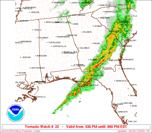
Tornado Watch Number 22
NWS Storm Prediction Center Norman OK
335 PM EST Thu Jan 12 2023
The NWS Storm Prediction Center has issued a
* Tornado Watch for portions of
Southeast Alabama
Florida Panhandle
Southwest Georgia
* Effective this Thursday afternoon and evening from 335 PM until
900 PM EST.
* Primary threats include...
A couple tornadoes possible
Scattered damaging wind gusts to 65 mph possible
Isolated large hail events to 1 inch in diameter possible
SUMMARY...A few semi-discrete supercells will remain possible ahead
of more linearly organized bands of convection. Damaging winds and a
tornado risk will exist will these storms as they move
east-northeastward across the region through evening.
The tornado watch area is approximately along and 45 statute miles
north and south of a line from 45 miles south southwest of Troy AL
to 15 miles north northeast of Moultrie GA. For a complete depiction
of the watch see the associated watch outline update (WOUS64 KWNS
WOU2).
PRECAUTIONARY/PREPAREDNESS ACTIONS...
REMEMBER...A Tornado Watch means conditions are favorable for
tornadoes and severe thunderstorms in and close to the watch
area. Persons in these areas should be on the lookout for
threatening weather conditions and listen for later statements
and possible warnings.
&&
OTHER WATCH INFORMATION...CONTINUE...WW 19...WW 20...WW 21...
AVIATION...Tornadoes and a few severe thunderstorms with hail
surface and aloft to 1 inch. Extreme turbulence and surface wind
gusts to 55 knots. A few cumulonimbi with maximum tops to 450. Mean
storm motion vector 25025.
...Guyer
 Note:
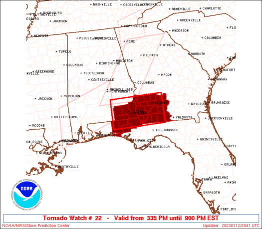
The Aviation Watch (SAW) product is an approximation to the watch area.
The actual watch is depicted by the shaded areas.
Note:
The Aviation Watch (SAW) product is an approximation to the watch area.
The actual watch is depicted by the shaded areas.
   SAW2
   WW 22 TORNADO AL FL GA 122035Z - 130200Z
   AXIS..45 STATUTE MILES NORTH AND SOUTH OF LINE..
   45SSW TOI/TROY AL/ - 15NNE MGR/MOULTRIE GA/
   ..AVIATION COORDS.. 40NM N/S /32NE CEW - 38SE PZD/
   HAIL SURFACE AND ALOFT..1 INCH. WIND GUSTS..55 KNOTS.
   MAX TOPS TO 450. MEAN STORM MOTION VECTOR 25025.

   LAT...LON 31928631 31938370 30638370 30628631

   THIS IS AN APPROXIMATION TO THE WATCH AREA.  FOR A
   COMPLETE DEPICTION OF THE WATCH SEE WOUS64 KWNS
   FOR WOU2.
Watch 22 Status Report Messages:
STATUS REPORT #5 ON WW 22

VALID 130140Z - 130240Z

SEVERE WEATHER THREAT CONTINUES RIGHT OF A LINE FROM 25 SW MAI TO
30 E ABY.

..SPC..01/13/23

ATTN...WFO...TAE...

&&

STATUS REPORT FOR WT 22

SEVERE WEATHER THREAT CONTINUES FOR THE FOLLOWING AREAS

GAC017-019-027-071-075-087-131-155-173-185-205-253-275-277-321-
130240-

GA
.    GEORGIA COUNTIES INCLUDED ARE

BEN HILL	     BERRIEN		 BROOKS
COLQUITT	     COOK		 DECATUR
GRADY		     IRWIN		 LANIER
LOWNDES 	     MITCHELL		 SEMINOLE
THOMAS		     TIFT		 WORTH
$$


THE WATCH STATUS MESSAGE IS FOR GUIDANCE PURPOSES ONLY.  PLEASE
REFER TO WATCH COUNTY NOTIFICATION STATEMENTS FOR OFFICIAL
INFORMATION ON COUNTIES...INDEPENDENT CITIES AND MARINE ZONES
CLEARED FROM SEVERE THUNDERSTORM AND TORNADO WATCHES.
$$

STATUS REPORT #4 ON WW 22

VALID 130030Z - 130140Z

SEVERE WEATHER THREAT CONTINUES RIGHT OF A LINE FROM 10 NNE CEW
TO 5 NE DHN TO 35 W ABY TO 45 N ABY.

..MOORE..01/13/23

ATTN...WFO...TAE...

&&

STATUS REPORT FOR WT 22

SEVERE WEATHER THREAT CONTINUES FOR THE FOLLOWING AREAS

ALC061-069-130140-

AL
.    ALABAMA COUNTIES INCLUDED ARE

GENEVA		     HOUSTON
$$


FLC059-063-131-133-130140-

FL
.    FLORIDA COUNTIES INCLUDED ARE

HOLMES		     JACKSON		 WALTON
WASHINGTON
$$


GAC007-027-037-071-087-095-099-131-177-201-205-253-273-275-277-
287-321-130140-

GA
.    GEORGIA COUNTIES INCLUDED ARE

BAKER		     BROOKS		 CALHOUN
COLQUITT	     DECATUR		 DOUGHERTY
EARLY		     GRADY		 LEE
MILLER		     MITCHELL		 SEMINOLE
TERRELL 	     THOMAS		 TIFT
TURNER		     WORTH
$$


THE WATCH STATUS MESSAGE IS FOR GUIDANCE PURPOSES ONLY.  PLEASE
REFER TO WATCH COUNTY NOTIFICATION STATEMENTS FOR OFFICIAL
INFORMATION ON COUNTIES...INDEPENDENT CITIES AND MARINE ZONES
CLEARED FROM SEVERE THUNDERSTORM AND TORNADO WATCHES.
$$

STATUS REPORT #3 ON WW 22

VALID 122330Z - 130040Z

SEVERE WEATHER THREAT CONTINUES RIGHT OF A LINE FROM 15 NNW CEW
TO 20 W DHN TO 40 NNW ABY.

..MOORE..01/12/23

ATTN...WFO...TAE...

&&

STATUS REPORT FOR WT 22

SEVERE WEATHER THREAT CONTINUES FOR THE FOLLOWING AREAS

ALC045-061-067-069-130040-

AL
.    ALABAMA COUNTIES INCLUDED ARE

DALE		     GENEVA		 HENRY
HOUSTON
$$


FLC059-063-131-133-130040-

FL
.    FLORIDA COUNTIES INCLUDED ARE

HOLMES		     JACKSON		 WALTON
WASHINGTON
$$


GAC007-027-037-061-071-087-095-099-131-177-201-205-243-253-273-
275-277-287-321-130040-

GA
.    GEORGIA COUNTIES INCLUDED ARE

BAKER		     BROOKS		 CALHOUN
CLAY		     COLQUITT		 DECATUR
DOUGHERTY	     EARLY		 GRADY
LEE		     MILLER		 MITCHELL
RANDOLPH	     SEMINOLE		 TERRELL
THOMAS		     TIFT		 TURNER
WORTH
$$


THE WATCH STATUS MESSAGE IS FOR GUIDANCE PURPOSES ONLY.  PLEASE
REFER TO WATCH COUNTY NOTIFICATION STATEMENTS FOR OFFICIAL
INFORMATION ON COUNTIES...INDEPENDENT CITIES AND MARINE ZONES
CLEARED FROM SEVERE THUNDERSTORM AND TORNADO WATCHES.
$$

STATUS REPORT #2 ON WW 22

VALID 122225Z - 122340Z

THE SEVERE WEATHER THREAT CONTINUES ACROSS THE ENTIRE WATCH AREA.

FOR ADDITIONAL INFORMATION SEE MESOSCALE DISCUSSION 61

..MOORE..01/12/23

ATTN...WFO...TAE...

&&

STATUS REPORT FOR WT 22

SEVERE WEATHER THREAT CONTINUES FOR THE FOLLOWING AREAS

ALC031-045-061-067-069-122340-

AL
.    ALABAMA COUNTIES INCLUDED ARE

COFFEE		     DALE		 GENEVA
HENRY		     HOUSTON
$$


FLC059-063-131-133-122340-

FL
.    FLORIDA COUNTIES INCLUDED ARE

HOLMES		     JACKSON		 WALTON
WASHINGTON
$$


GAC007-027-037-061-071-087-095-099-131-177-201-205-239-243-253-
273-275-277-287-321-122340-

GA
.    GEORGIA COUNTIES INCLUDED ARE

BAKER		     BROOKS		 CALHOUN
CLAY		     COLQUITT		 DECATUR
DOUGHERTY	     EARLY		 GRADY
LEE		     MILLER		 MITCHELL
QUITMAN 	     RANDOLPH		 SEMINOLE
TERRELL 	     THOMAS		 TIFT
TURNER		     WORTH
$$


THE WATCH STATUS MESSAGE IS FOR GUIDANCE PURPOSES ONLY.  PLEASE
REFER TO WATCH COUNTY NOTIFICATION STATEMENTS FOR OFFICIAL
INFORMATION ON COUNTIES...INDEPENDENT CITIES AND MARINE ZONES
CLEARED FROM SEVERE THUNDERSTORM AND TORNADO WATCHES.
$$

STATUS REPORT #1 ON WW 22

VALID 122135Z - 122240Z

THE SEVERE WEATHER THREAT CONTINUES ACROSS THE ENTIRE WATCH AREA.

..THORNTON..01/12/23

ATTN...WFO...TAE...

&&

STATUS REPORT FOR WT 22

SEVERE WEATHER THREAT CONTINUES FOR THE FOLLOWING AREAS

ALC031-045-061-067-069-122240-

AL
.    ALABAMA COUNTIES INCLUDED ARE

COFFEE		     DALE		 GENEVA
HENRY		     HOUSTON
$$


FLC059-063-131-133-122240-

FL
.    FLORIDA COUNTIES INCLUDED ARE

HOLMES		     JACKSON		 WALTON
WASHINGTON
$$


GAC007-027-037-061-071-087-095-099-131-177-201-205-239-243-253-
273-275-277-287-321-122240-

GA
.    GEORGIA COUNTIES INCLUDED ARE

BAKER		     BROOKS		 CALHOUN
CLAY		     COLQUITT		 DECATUR
DOUGHERTY	     EARLY		 GRADY
LEE		     MILLER		 MITCHELL
QUITMAN 	     RANDOLPH		 SEMINOLE
TERRELL 	     THOMAS		 TIFT
TURNER		     WORTH
$$


THE WATCH STATUS MESSAGE IS FOR GUIDANCE PURPOSES ONLY.  PLEASE
REFER TO WATCH COUNTY NOTIFICATION STATEMENTS FOR OFFICIAL
INFORMATION ON COUNTIES...INDEPENDENT CITIES AND MARINE ZONES
CLEARED FROM SEVERE THUNDERSTORM AND TORNADO WATCHES.
$$
Note:
Click for Complete Product Text.
Tornadoes
Probability of 2 or more tornadoes
|
Mod (40%)
|
Probability of 1 or more strong (EF2-EF5) tornadoes
|
Low (20%)
|
Wind
Probability of 10 or more severe wind events
|
Mod (50%)
|
Probability of 1 or more wind events > 65 knots
|
Low (<5%)
|
Hail
Probability of 10 or more severe hail events
|
Low (20%)
|
Probability of 1 or more hailstones > 2 inches
|
Low (10%)
|
Combined Severe Hail/Wind
Probability of 6 or more combined severe hail/wind events
|
High (70%)
|
For each watch, probabilities for particular events inside the watch
(listed above in each table) are determined by the issuing forecaster.
The "Low" category contains probability values ranging from less than 2%
to 20% (EF2-EF5 tornadoes), less than 5% to 20% (all other probabilities),
"Moderate" from 30% to 60%, and "High" from 70% to greater than 95%.
High values are bolded and lighter in color to provide awareness of
an increased threat for a particular event.


 @NWSSPC


