 Note:
The expiration time in the watch graphic is amended if the watch is
replaced, cancelled or extended.
Note:
Note:
The expiration time in the watch graphic is amended if the watch is
replaced, cancelled or extended.
Note: Click for
Watch Status Reports.
SEL8
URGENT - IMMEDIATE BROADCAST REQUESTED
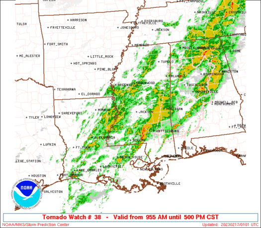
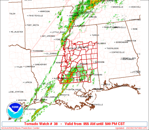
Tornado Watch Number 38
NWS Storm Prediction Center Norman OK
955 AM CST Thu Feb 16 2023
The NWS Storm Prediction Center has issued a
* Tornado Watch for portions of
Extreme northeast Louisiana
Central and southern Mississippi
* Effective this Thursday morning and afternoon from 955 AM until
500 PM CST.
* Primary threats include...
A few tornadoes likely with a couple intense tornadoes possible
Scattered damaging wind gusts to 70 mph likely
Scattered large hail events to 1.5 inches in diameter possible
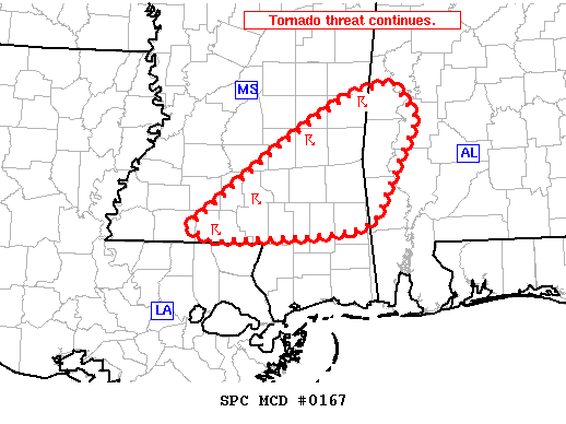
SUMMARY...Scattered supercells are expected to spread northeastward
into central Mississippi through the afternoon, with the threat for
a strong tornado or two, damaging gusts of 60-70 mph, and isolated
large hail up to 1.5 inches in diameter.
The tornado watch area is approximately along and 70 statute miles
east and west of a line from 15 miles south southwest of Mc Comb MS
to 35 miles east northeast of Greenwood MS. For a complete depiction
of the watch see the associated watch outline update (WOUS64 KWNS
WOU8).
PRECAUTIONARY/PREPAREDNESS ACTIONS...
REMEMBER...A Tornado Watch means conditions are favorable for
tornadoes and severe thunderstorms in and close to the watch
area. Persons in these areas should be on the lookout for
threatening weather conditions and listen for later statements
and possible warnings.
&&
OTHER WATCH INFORMATION...CONTINUE...WW 37...
AVIATION...Tornadoes and a few severe thunderstorms with hail
surface and aloft to 1.5 inches. Extreme turbulence and surface wind
gusts to 60 knots. A few cumulonimbi with maximum tops to 500. Mean
storm motion vector 23035.
...Thompson
   SEL8

   URGENT - IMMEDIATE BROADCAST REQUESTED
   Tornado Watch Number 38
   NWS Storm Prediction Center Norman OK
   955 AM CST Thu Feb 16 2023

   The NWS Storm Prediction Center has issued a

   * Tornado Watch for portions of
     Extreme northeast Louisiana
     Central and southern Mississippi

   * Effective this Thursday morning and afternoon from 955 AM until
     500 PM CST.

   * Primary threats include...
     A few tornadoes likely with a couple intense tornadoes possible
     Scattered damaging wind gusts to 70 mph likely
     Scattered large hail events to 1.5 inches in diameter possible

   SUMMARY...Scattered supercells are expected to spread northeastward
   into central Mississippi through the afternoon, with the threat for
   a strong tornado or two, damaging gusts of 60-70 mph, and isolated
   large hail up to 1.5 inches in diameter.

   The tornado watch area is approximately along and 70 statute miles
   east and west of a line from 15 miles south southwest of Mc Comb MS
   to 35 miles east northeast of Greenwood MS. For a complete depiction
   of the watch see the associated watch outline update (WOUS64 KWNS
   WOU8).

   PRECAUTIONARY/PREPAREDNESS ACTIONS...

   REMEMBER...A Tornado Watch means conditions are favorable for
   tornadoes and severe thunderstorms in and close to the watch
   area. Persons in these areas should be on the lookout for
   threatening weather conditions and listen for later statements
   and possible warnings.

   &&

   OTHER WATCH INFORMATION...CONTINUE...WW 37...

   AVIATION...Tornadoes and a few severe thunderstorms with hail
   surface and aloft to 1.5 inches. Extreme turbulence and surface wind
   gusts to 60 knots. A few cumulonimbi with maximum tops to 500. Mean
   storm motion vector 23035.

   ...Thompson
 Note:
The Aviation Watch (SAW) product is an approximation to the watch area.
The actual watch is depicted by the shaded areas.
Note:
The Aviation Watch (SAW) product is an approximation to the watch area.
The actual watch is depicted by the shaded areas.
   SAW8
   WW 38 TORNADO LA MS 161555Z - 162300Z
   AXIS..70 STATUTE MILES EAST AND WEST OF LINE..
   15SSW MCB/MC COMB MS/ - 35ENE GWO/GREENWOOD MS/
   ..AVIATION COORDS.. 60NM E/W /25SW MCB - 41ENE SQS/
   HAIL SURFACE AND ALOFT..1.5 INCHES. WIND GUSTS..60 KNOTS.
   MAX TOPS TO 500. MEAN STORM MOTION VECTOR 23035.

   LAT...LON 30979175 33689074 33688830 30978939

   THIS IS AN APPROXIMATION TO THE WATCH AREA.  FOR A
   COMPLETE DEPICTION OF THE WATCH SEE WOUS64 KWNS
   FOR WOU8.
Watch 38 Status Report Messages:
STATUS REPORT #4 ON WW 38

VALID 162235Z - 162340Z

SEVERE WEATHER THREAT CONTINUES RIGHT OF A LINE FROM 30 WSW MCB
TO 50 NNE MCB TO 65 S GWO TO 45 ENE GWO.

..KERR..02/16/23

ATTN...WFO...JAN...LIX...

&&

STATUS REPORT FOR WT 38

SEVERE WEATHER THREAT CONTINUES FOR THE FOLLOWING AREAS

MSC005-023-031-035-061-065-067-069-073-075-077-087-091-099-101-
103-113-123-127-129-147-159-162340-

MS
.    MISSISSIPPI COUNTIES INCLUDED ARE

AMITE		     CLARKE		 COVINGTON
FORREST 	     JASPER		 JEFFERSON DAVIS
JONES		     KEMPER		 LAMAR
LAUDERDALE	     LAWRENCE		 LOWNDES
MARION		     NESHOBA		 NEWTON
NOXUBEE 	     PIKE		 SCOTT
SIMPSON 	     SMITH		 WALTHALL
WINSTON
$$


THE WATCH STATUS MESSAGE IS FOR GUIDANCE PURPOSES ONLY.  PLEASE
REFER TO WATCH COUNTY NOTIFICATION STATEMENTS FOR OFFICIAL
INFORMATION ON COUNTIES...INDEPENDENT CITIES AND MARINE ZONES
CLEARED FROM SEVERE THUNDERSTORM AND TORNADO WATCHES.
$$

STATUS REPORT #3 ON WW 38

VALID 162130Z - 162240Z

SEVERE WEATHER THREAT CONTINUES RIGHT OF A LINE FROM 35 WSW MCB
TO 15 SE HEZ TO 40 NE HEZ TO 70 S GWO TO 35 S GWO TO 40 NE GWO.

..LYONS..02/16/23

ATTN...WFO...JAN...LIX...

&&

STATUS REPORT FOR WT 38

SEVERE WEATHER THREAT CONTINUES FOR THE FOLLOWING AREAS

MSC005-007-019-023-025-029-031-035-037-051-061-065-067-069-073-
075-077-079-085-087-089-091-097-099-101-103-105-113-121-123-127-
129-147-155-159-162240-

MS
.    MISSISSIPPI COUNTIES INCLUDED ARE

AMITE		     ATTALA		 CHOCTAW
CLARKE		     CLAY		 COPIAH
COVINGTON	     FORREST		 FRANKLIN
HOLMES		     JASPER		 JEFFERSON DAVIS
JONES		     KEMPER		 LAMAR
LAUDERDALE	     LAWRENCE		 LEAKE
LINCOLN 	     LOWNDES		 MADISON
MARION		     MONTGOMERY 	 NESHOBA
NEWTON		     NOXUBEE		 OKTIBBEHA
PIKE		     RANKIN		 SCOTT
SIMPSON 	     SMITH		 WALTHALL
WEBSTER 	     WINSTON
$$


THE WATCH STATUS MESSAGE IS FOR GUIDANCE PURPOSES ONLY.  PLEASE
REFER TO WATCH COUNTY NOTIFICATION STATEMENTS FOR OFFICIAL
INFORMATION ON COUNTIES...INDEPENDENT CITIES AND MARINE ZONES
CLEARED FROM SEVERE THUNDERSTORM AND TORNADO WATCHES.
$$

STATUS REPORT #2 ON WW 38

VALID 161935Z - 162040Z

SEVERE WEATHER THREAT CONTINUES RIGHT OF A LINE FROM 15 W HEZ TO
30 NNE HEZ TO 65 SSE GLH TO 15 SSW GWO TO 15 NNE GWO TO 20 NNE
GWO.

..LYONS..02/16/23

ATTN...WFO...JAN...LIX...

&&

STATUS REPORT FOR WT 38

SEVERE WEATHER THREAT CONTINUES FOR THE FOLLOWING AREAS

LAC029-162040-

LA
.    LOUISIANA PARISHES INCLUDED ARE

CONCORDIA
$$


MSC001-005-007-015-019-021-023-025-029-031-035-037-043-049-051-
061-063-065-067-069-073-075-077-079-085-087-089-091-097-099-101-
103-105-113-121-123-127-129-147-149-155-157-159-163-162040-

MS
.    MISSISSIPPI COUNTIES INCLUDED ARE

ADAMS		     AMITE		 ATTALA
CARROLL 	     CHOCTAW		 CLAIBORNE
CLARKE		     CLAY		 COPIAH
COVINGTON	     FORREST		 FRANKLIN
GRENADA 	     HINDS		 HOLMES
JASPER		     JEFFERSON		 JEFFERSON DAVIS
JONES		     KEMPER		 LAMAR
LAUDERDALE	     LAWRENCE		 LEAKE
LINCOLN 	     LOWNDES		 MADISON
MARION		     MONTGOMERY 	 NESHOBA
NEWTON		     NOXUBEE		 OKTIBBEHA
PIKE		     RANKIN		 SCOTT
SIMPSON 	     SMITH		 WALTHALL
WARREN		     WEBSTER		 WILKINSON
WINSTON 	     YAZOO
$$


THE WATCH STATUS MESSAGE IS FOR GUIDANCE PURPOSES ONLY.  PLEASE
REFER TO WATCH COUNTY NOTIFICATION STATEMENTS FOR OFFICIAL
INFORMATION ON COUNTIES...INDEPENDENT CITIES AND MARINE ZONES
CLEARED FROM SEVERE THUNDERSTORM AND TORNADO WATCHES.
$$

STATUS REPORT #1 ON WW 38

VALID 161830Z - 161940Z

SEVERE WEATHER THREAT CONTINUES RIGHT OF A LINE FROM 40 E MLU TO
30 S GLH TO 35 NE GLH.

FOR ADDITIONAL INFORMATION SEE MESOSCALE DISCUSSION 164

..LYONS..02/16/23

ATTN...WFO...JAN...LIX...

&&

STATUS REPORT FOR WT 38

SEVERE WEATHER THREAT CONTINUES FOR THE FOLLOWING AREAS

LAC029-065-107-161940-

LA
.    LOUISIANA PARISHES INCLUDED ARE

CONCORDIA	     MADISON		 TENSAS
$$


MSC001-005-007-015-019-021-023-025-029-031-035-037-043-049-051-
053-055-061-063-065-067-069-073-075-077-079-083-085-087-089-091-
097-099-101-103-105-113-121-123-125-127-129-133-147-149-155-157-
159-163-161940-

MS
.    MISSISSIPPI COUNTIES INCLUDED ARE

ADAMS		     AMITE		 ATTALA
CARROLL 	     CHOCTAW		 CLAIBORNE
CLARKE		     CLAY		 COPIAH
COVINGTON	     FORREST		 FRANKLIN
GRENADA 	     HINDS		 HOLMES
HUMPHREYS	     ISSAQUENA		 JASPER
JEFFERSON	     JEFFERSON DAVIS	 JONES
KEMPER		     LAMAR		 LAUDERDALE
LAWRENCE	     LEAKE		 LEFLORE
LINCOLN 	     LOWNDES		 MADISON
MARION		     MONTGOMERY 	 NESHOBA
NEWTON		     NOXUBEE		 OKTIBBEHA
PIKE		     RANKIN		 SCOTT
SHARKEY 	     SIMPSON		 SMITH
SUNFLOWER	     WALTHALL		 WARREN
WEBSTER 	     WILKINSON		 WINSTON
YAZOO
$$


THE WATCH STATUS MESSAGE IS FOR GUIDANCE PURPOSES ONLY.  PLEASE
REFER TO WATCH COUNTY NOTIFICATION STATEMENTS FOR OFFICIAL
INFORMATION ON COUNTIES...INDEPENDENT CITIES AND MARINE ZONES
CLEARED FROM SEVERE THUNDERSTORM AND TORNADO WATCHES.
$$
Note:
Click for Complete Product Text.
Tornadoes
Probability of 2 or more tornadoes
|
High (70%)
|
Probability of 1 or more strong (EF2-EF5) tornadoes
|
Mod (40%)
|
Wind
Probability of 10 or more severe wind events
|
Mod (60%)
|
Probability of 1 or more wind events > 65 knots
|
Low (20%)
|
Hail
Probability of 10 or more severe hail events
|
Mod (40%)
|
Probability of 1 or more hailstones > 2 inches
|
Low (20%)
|
Combined Severe Hail/Wind
Probability of 6 or more combined severe hail/wind events
|
High (90%)
|
For each watch, probabilities for particular events inside the watch
(listed above in each table) are determined by the issuing forecaster.
The "Low" category contains probability values ranging from less than 2%
to 20% (EF2-EF5 tornadoes), less than 5% to 20% (all other probabilities),
"Moderate" from 30% to 60%, and "High" from 70% to greater than 95%.
High values are bolded and lighter in color to provide awareness of
an increased threat for a particular event.


 @NWSSPC