 Note:
The expiration time in the watch graphic is amended if the watch is
replaced, cancelled or extended.
Note:
Note:
The expiration time in the watch graphic is amended if the watch is
replaced, cancelled or extended.
Note: Click for
Watch Status Reports.
SEL7
URGENT - IMMEDIATE BROADCAST REQUESTED
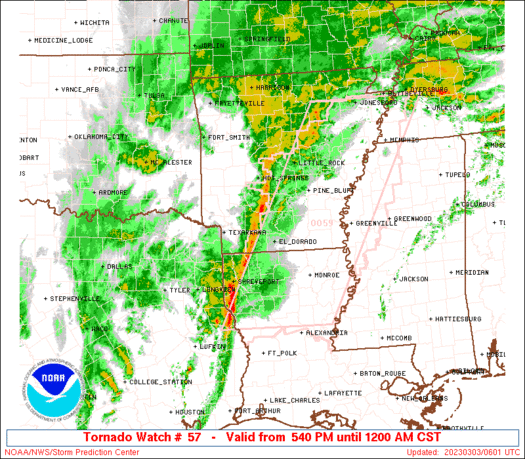
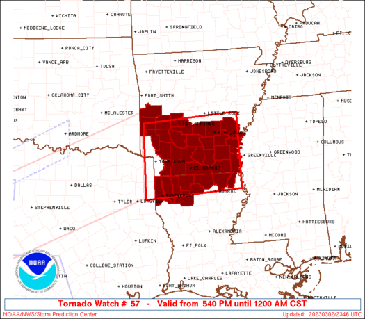
Tornado Watch Number 57
NWS Storm Prediction Center Norman OK
540 PM CST Thu Mar 2 2023
The NWS Storm Prediction Center has issued a
* Tornado Watch for portions of
Southern and central Arkansas
Northern Louisiana
* Effective this Thursday afternoon from 540 PM until Midnight
CST.
* Primary threats include...
A few tornadoes likely with a couple intense tornadoes possible
Widespread damaging winds and isolated significant gusts to 80
mph likely
Scattered large hail likely with isolated very large hail events
to 2.5 inches in diameter possible
SUMMARY...Supercells and bowing thunderstorm clusters will pose a
threat for tornadoes, large to very large hail, and significant
damaging winds this evening into tonight.
The tornado watch area is approximately along and 75 statute miles
north and south of a line from 20 miles west of Texarkana AR to 35
miles east of Monticello AR. For a complete depiction of the watch
see the associated watch outline update (WOUS64 KWNS WOU7).
PRECAUTIONARY/PREPAREDNESS ACTIONS...
REMEMBER...A Tornado Watch means conditions are favorable for
tornadoes and severe thunderstorms in and close to the watch
area. Persons in these areas should be on the lookout for
threatening weather conditions and listen for later statements
and possible warnings.
&&
OTHER WATCH INFORMATION...CONTINUE...WW 53...WW 54...WW 55...WW
56...
AVIATION...Tornadoes and a few severe thunderstorms with hail
surface and aloft to 2.5 inches. Extreme turbulence and surface wind
gusts to 70 knots. A few cumulonimbi with maximum tops to 500. Mean
storm motion vector 25040.
...Gleason/Guyer
   SEL7

   URGENT - IMMEDIATE BROADCAST REQUESTED
   Tornado Watch Number 57
   NWS Storm Prediction Center Norman OK
   540 PM CST Thu Mar 2 2023

   The NWS Storm Prediction Center has issued a

   * Tornado Watch for portions of
     Southern and central Arkansas
     Northern Louisiana

   * Effective this Thursday afternoon from 540 PM until Midnight
     CST.

   * Primary threats include...
     A few tornadoes likely with a couple intense tornadoes possible
     Widespread damaging winds and isolated significant gusts to 80
       mph likely
     Scattered large hail likely with isolated very large hail events
       to 2.5 inches in diameter possible

   SUMMARY...Supercells and bowing thunderstorm clusters will pose a
   threat for tornadoes, large to very large hail, and significant
   damaging winds this evening into tonight.

   The tornado watch area is approximately along and 75 statute miles
   north and south of a line from 20 miles west of Texarkana AR to 35
   miles east of Monticello AR. For a complete depiction of the watch
   see the associated watch outline update (WOUS64 KWNS WOU7).

   PRECAUTIONARY/PREPAREDNESS ACTIONS...

   REMEMBER...A Tornado Watch means conditions are favorable for
   tornadoes and severe thunderstorms in and close to the watch
   area. Persons in these areas should be on the lookout for
   threatening weather conditions and listen for later statements
   and possible warnings.

   &&

   OTHER WATCH INFORMATION...CONTINUE...WW 53...WW 54...WW 55...WW
   56...

   AVIATION...Tornadoes and a few severe thunderstorms with hail
   surface and aloft to 2.5 inches. Extreme turbulence and surface wind
   gusts to 70 knots. A few cumulonimbi with maximum tops to 500. Mean
   storm motion vector 25040.

   ...Gleason/Guyer
 Note:
The Aviation Watch (SAW) product is an approximation to the watch area.
The actual watch is depicted by the shaded areas.
Note:
The Aviation Watch (SAW) product is an approximation to the watch area.
The actual watch is depicted by the shaded areas.
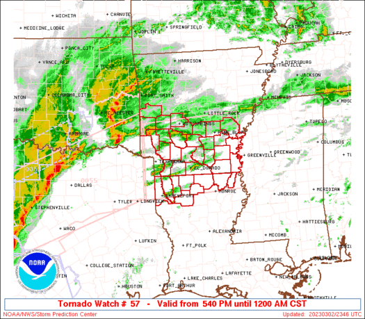
   SAW7
   WW 57 TORNADO AR LA 022340Z - 030600Z
   AXIS..75 STATUTE MILES NORTH AND SOUTH OF LINE..
   20W TXK/TEXARKANA AR/ - 35E LLQ/MONTICELLO AR/
   ..AVIATION COORDS.. 65NM N/S /14WSW TXK - 44WNW SQS/
   HAIL SURFACE AND ALOFT..2.5 INCHES. WIND GUSTS..70 KNOTS.
   MAX TOPS TO 500. MEAN STORM MOTION VECTOR 25040.

   LAT...LON 34539435 34729114 32559114 32369435

   THIS IS AN APPROXIMATION TO THE WATCH AREA.  FOR A
   COMPLETE DEPICTION OF THE WATCH SEE WOUS64 KWNS
   FOR WOU7.
Watch 57 Status Report Messages:
STATUS REPORT #6 ON WW 57
VALID 030530Z - 030640Z
SEVERE WEATHER THREAT CONTINUES RIGHT OF A LINE FROM 25 ENE LFK
TO 40 SE GGG TO 10 NW SHV TO 35 N SHV TO 25 E TXK TO 45 SSW HOT
TO 10 NNW HOT TO 30 SE RUE TO 20 NNW LIT TO 35 NNE LIT TO 15 WSW
BVX.
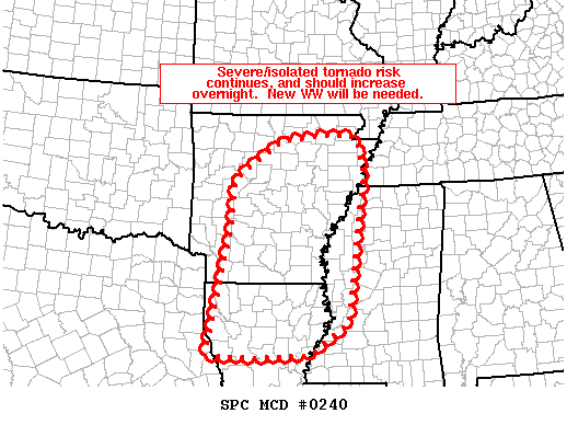
FOR ADDITIONAL INFORMATION SEE MESOSCALE DISCUSSION 240
..FLOURNOY..03/03/23
ATTN...WFO...LZK...JAN...SHV...
&&
STATUS REPORT FOR WT 57
SEVERE WEATHER THREAT CONTINUES FOR THE FOLLOWING AREAS
ARC001-003-011-013-017-019-025-027-039-041-043-051-053-059-069-
073-079-085-099-103-117-119-125-139-030640-
AR
. ARKANSAS COUNTIES INCLUDED ARE
ARKANSAS ASHLEY BRADLEY
CALHOUN CHICOT CLARK
CLEVELAND COLUMBIA DALLAS
DESHA DREW GARLAND
GRANT HOT SPRING JEFFERSON
LAFAYETTE LINCOLN LONOKE
NEVADA OUACHITA PRAIRIE
PULASKI SALINE UNION
$$
LAC013-015-017-027-031-043-061-067-069-081-085-111-119-123-
030640-
LA
. LOUISIANA PARISHES INCLUDED ARE
BIENVILLE BOSSIER CADDO
CLAIBORNE DE SOTO GRANT
LINCOLN MOREHOUSE NATCHITOCHES
RED RIVER SABINE UNION
WEBSTER WEST CARROLL
$$
THE WATCH STATUS MESSAGE IS FOR GUIDANCE PURPOSES ONLY. PLEASE
REFER TO WATCH COUNTY NOTIFICATION STATEMENTS FOR OFFICIAL
INFORMATION ON COUNTIES...INDEPENDENT CITIES AND MARINE ZONES
CLEARED FROM SEVERE THUNDERSTORM AND TORNADO WATCHES.
$$
STATUS REPORT #5 ON WW 57
VALID 030430Z - 030540Z
SEVERE WEATHER THREAT CONTINUES RIGHT OF A LINE FROM 20 NE GGG TO
5 WSW TXK TO 30 E DEQ TO 45 ESE RKR TO 15 WNW RUE.
FOR ADDITIONAL INFORMATION SEE MESOSCALE DISCUSSION 239
..FLOURNOY..03/03/23
ATTN...WFO...LZK...JAN...SHV...
&&
STATUS REPORT FOR WT 57
SEVERE WEATHER THREAT CONTINUES FOR THE FOLLOWING AREAS
ARC001-003-011-013-017-019-025-027-039-041-043-051-053-057-059-
061-069-073-079-085-097-099-103-105-109-117-119-125-139-149-
030540-
AR
. ARKANSAS COUNTIES INCLUDED ARE
ARKANSAS ASHLEY BRADLEY
CALHOUN CHICOT CLARK
CLEVELAND COLUMBIA DALLAS
DESHA DREW GARLAND
GRANT HEMPSTEAD HOT SPRING
HOWARD JEFFERSON LAFAYETTE
LINCOLN LONOKE MONTGOMERY
NEVADA OUACHITA PERRY
PIKE PRAIRIE PULASKI
SALINE UNION YELL
$$
LAC013-015-017-027-031-043-061-067-069-081-085-111-119-123-
030540-
LA
. LOUISIANA PARISHES INCLUDED ARE
BIENVILLE BOSSIER CADDO
CLAIBORNE DE SOTO GRANT
LINCOLN MOREHOUSE NATCHITOCHES
RED RIVER SABINE UNION
WEBSTER WEST CARROLL
$$
THE WATCH STATUS MESSAGE IS FOR GUIDANCE PURPOSES ONLY. PLEASE
REFER TO WATCH COUNTY NOTIFICATION STATEMENTS FOR OFFICIAL
INFORMATION ON COUNTIES...INDEPENDENT CITIES AND MARINE ZONES
CLEARED FROM SEVERE THUNDERSTORM AND TORNADO WATCHES.
$$
STATUS REPORT #4 ON WW 57
VALID 030330Z - 030440Z
THE SEVERE WEATHER THREAT CONTINUES ACROSS THE ENTIRE WATCH AREA.
..FLOURNOY..03/03/23
ATTN...WFO...LZK...JAN...SHV...
&&
STATUS REPORT FOR WT 57
SEVERE WEATHER THREAT CONTINUES FOR THE FOLLOWING AREAS
ARC001-003-011-013-017-019-025-027-039-041-043-051-053-057-059-
061-069-073-079-097-099-103-109-113-127-139-030440-
AR
. ARKANSAS COUNTIES INCLUDED ARE
ARKANSAS ASHLEY BRADLEY
CALHOUN CHICOT CLARK
CLEVELAND COLUMBIA DALLAS
DESHA DREW GARLAND
GRANT HEMPSTEAD HOT SPRING
HOWARD JEFFERSON LAFAYETTE
LINCOLN MONTGOMERY NEVADA
OUACHITA PIKE POLK
SCOTT UNION
$$
LAC013-015-017-027-061-067-111-119-123-030440-
LA
. LOUISIANA PARISHES INCLUDED ARE
BIENVILLE BOSSIER CADDO
CLAIBORNE LINCOLN MOREHOUSE
UNION WEBSTER WEST CARROLL
$$
THE WATCH STATUS MESSAGE IS FOR GUIDANCE PURPOSES ONLY. PLEASE
REFER TO WATCH COUNTY NOTIFICATION STATEMENTS FOR OFFICIAL
INFORMATION ON COUNTIES...INDEPENDENT CITIES AND MARINE ZONES
CLEARED FROM SEVERE THUNDERSTORM AND TORNADO WATCHES.
$$
STATUS REPORT #3 ON WW 57
VALID 030230Z - 030340Z
THE SEVERE WEATHER THREAT CONTINUES ACROSS THE ENTIRE WATCH AREA.
..FLOURNOY..03/03/23
ATTN...WFO...LZK...JAN...SHV...
&&
STATUS REPORT FOR WT 57
SEVERE WEATHER THREAT CONTINUES FOR THE FOLLOWING AREAS
ARC001-003-011-013-017-019-025-027-039-041-043-051-053-057-059-
061-069-073-079-097-099-103-109-113-127-139-030340-
AR
. ARKANSAS COUNTIES INCLUDED ARE
ARKANSAS ASHLEY BRADLEY
CALHOUN CHICOT CLARK
CLEVELAND COLUMBIA DALLAS
DESHA DREW GARLAND
GRANT HEMPSTEAD HOT SPRING
HOWARD JEFFERSON LAFAYETTE
LINCOLN MONTGOMERY NEVADA
OUACHITA PIKE POLK
SCOTT UNION
$$
LAC013-015-017-027-061-067-111-119-123-030340-
LA
. LOUISIANA PARISHES INCLUDED ARE
BIENVILLE BOSSIER CADDO
CLAIBORNE LINCOLN MOREHOUSE
UNION WEBSTER WEST CARROLL
$$
THE WATCH STATUS MESSAGE IS FOR GUIDANCE PURPOSES ONLY. PLEASE
REFER TO WATCH COUNTY NOTIFICATION STATEMENTS FOR OFFICIAL
INFORMATION ON COUNTIES...INDEPENDENT CITIES AND MARINE ZONES
CLEARED FROM SEVERE THUNDERSTORM AND TORNADO WATCHES.
$$
STATUS REPORT #2 ON WW 57
VALID 030130Z - 030240Z
THE SEVERE WEATHER THREAT CONTINUES ACROSS THE ENTIRE WATCH AREA.
FOR ADDITIONAL INFORMATION SEE MESOSCALE DISCUSSION 235
..FLOURNOY..03/03/23
ATTN...WFO...LZK...JAN...SHV...
&&
STATUS REPORT FOR WT 57
SEVERE WEATHER THREAT CONTINUES FOR THE FOLLOWING AREAS
ARC001-003-011-013-017-019-025-027-039-041-043-051-053-057-059-
061-069-073-079-097-099-103-109-113-127-139-030240-
AR
. ARKANSAS COUNTIES INCLUDED ARE
ARKANSAS ASHLEY BRADLEY
CALHOUN CHICOT CLARK
CLEVELAND COLUMBIA DALLAS
DESHA DREW GARLAND
GRANT HEMPSTEAD HOT SPRING
HOWARD JEFFERSON LAFAYETTE
LINCOLN MONTGOMERY NEVADA
OUACHITA PIKE POLK
SCOTT UNION
$$
LAC013-015-017-027-061-067-111-119-123-030240-
LA
. LOUISIANA PARISHES INCLUDED ARE
BIENVILLE BOSSIER CADDO
CLAIBORNE LINCOLN MOREHOUSE
UNION WEBSTER WEST CARROLL
$$
THE WATCH STATUS MESSAGE IS FOR GUIDANCE PURPOSES ONLY. PLEASE
REFER TO WATCH COUNTY NOTIFICATION STATEMENTS FOR OFFICIAL
INFORMATION ON COUNTIES...INDEPENDENT CITIES AND MARINE ZONES
CLEARED FROM SEVERE THUNDERSTORM AND TORNADO WATCHES.
$$
STATUS REPORT #1 ON WW 57
VALID 030035Z - 030140Z
THE SEVERE WEATHER THREAT CONTINUES ACROSS THE ENTIRE WATCH AREA.
..FLOURNOY..03/03/23
ATTN...WFO...LZK...JAN...SHV...
&&
STATUS REPORT FOR WT 57
SEVERE WEATHER THREAT CONTINUES FOR THE FOLLOWING AREAS
ARC001-003-011-013-017-019-025-027-039-041-043-051-053-057-059-
061-069-073-079-097-099-103-109-113-127-139-030140-
AR
. ARKANSAS COUNTIES INCLUDED ARE
ARKANSAS ASHLEY BRADLEY
CALHOUN CHICOT CLARK
CLEVELAND COLUMBIA DALLAS
DESHA DREW GARLAND
GRANT HEMPSTEAD HOT SPRING
HOWARD JEFFERSON LAFAYETTE
LINCOLN MONTGOMERY NEVADA
OUACHITA PIKE POLK
SCOTT UNION
$$
LAC013-015-017-027-061-067-111-119-123-030140-
LA
. LOUISIANA PARISHES INCLUDED ARE
BIENVILLE BOSSIER CADDO
CLAIBORNE LINCOLN MOREHOUSE
UNION WEBSTER WEST CARROLL
$$
THE WATCH STATUS MESSAGE IS FOR GUIDANCE PURPOSES ONLY. PLEASE
REFER TO WATCH COUNTY NOTIFICATION STATEMENTS FOR OFFICIAL
INFORMATION ON COUNTIES...INDEPENDENT CITIES AND MARINE ZONES
CLEARED FROM SEVERE THUNDERSTORM AND TORNADO WATCHES.
$$
Note:
Click for Complete Product Text.
Tornadoes
Probability of 2 or more tornadoes
|
High (70%)
|
Probability of 1 or more strong (EF2-EF5) tornadoes
|
Mod (50%)
|
Wind
Probability of 10 or more severe wind events
|
High (80%)
|
Probability of 1 or more wind events > 65 knots
|
Mod (60%)
|
Hail
Probability of 10 or more severe hail events
|
Mod (60%)
|
Probability of 1 or more hailstones > 2 inches
|
Mod (50%)
|
Combined Severe Hail/Wind
Probability of 6 or more combined severe hail/wind events
|
High (>95%)
|
For each watch, probabilities for particular events inside the watch
(listed above in each table) are determined by the issuing forecaster.
The "Low" category contains probability values ranging from less than 2%
to 20% (EF2-EF5 tornadoes), less than 5% to 20% (all other probabilities),
"Moderate" from 30% to 60%, and "High" from 70% to greater than 95%.
High values are bolded and lighter in color to provide awareness of
an increased threat for a particular event.


 @NWSSPC