 Note:
The expiration time in the watch graphic is amended if the watch is
replaced, cancelled or extended.
Note:
Note:
The expiration time in the watch graphic is amended if the watch is
replaced, cancelled or extended.
Note: Click for
Watch Status Reports.
SEL3
URGENT - IMMEDIATE BROADCAST REQUESTED
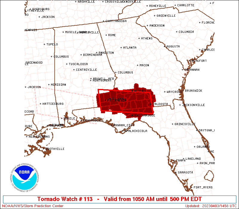
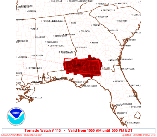
Tornado Watch Number 113
NWS Storm Prediction Center Norman OK
1050 AM EDT Mon Apr 3 2023
The NWS Storm Prediction Center has issued a
* Tornado Watch for portions of
Southeast Alabama
The Florida Panhandle
Southwest Georgia
* Effective this Monday morning and afternoon from 1050 AM until
500 PM EDT.
* Primary threats include...
A couple tornadoes possible
Scattered damaging wind gusts to 70 mph possible
Isolated large hail events to 1.5 inches in diameter possible
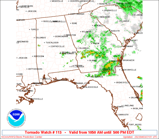
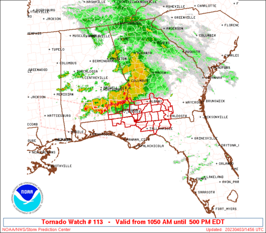
SUMMARY...Clusters of thunderstorms will spread east-southeastward
through the afternoon, posing a threat for mainly damaging winds and
a couple of tornadoes.
The tornado watch area is approximately along and 35 statute miles
north and south of a line from 35 miles west of Dothan AL to 5 miles
northeast of Valdosta GA. For a complete depiction of the watch see
the associated watch outline update (WOUS64 KWNS WOU3).
PRECAUTIONARY/PREPAREDNESS ACTIONS...
REMEMBER...A Tornado Watch means conditions are favorable for
tornadoes and severe thunderstorms in and close to the watch
area. Persons in these areas should be on the lookout for
threatening weather conditions and listen for later statements
and possible warnings.
&&
OTHER WATCH INFORMATION...CONTINUE...WW 112...
AVIATION...Tornadoes and a few severe thunderstorms with hail
surface and aloft to 1.5 inches. Extreme turbulence and surface wind
gusts to 60 knots. A few cumulonimbi with maximum tops to 500. Mean
storm motion vector 29030.
...Gleason/Hart
   SEL3

   URGENT - IMMEDIATE BROADCAST REQUESTED
   Tornado Watch Number 113
   NWS Storm Prediction Center Norman OK
   1050 AM EDT Mon Apr 3 2023

   The NWS Storm Prediction Center has issued a

   * Tornado Watch for portions of
     Southeast Alabama
     The Florida Panhandle
     Southwest Georgia

   * Effective this Monday morning and afternoon from 1050 AM until
     500 PM EDT.

   * Primary threats include...
     A couple tornadoes possible
     Scattered damaging wind gusts to 70 mph possible
     Isolated large hail events to 1.5 inches in diameter possible

   SUMMARY...Clusters of thunderstorms will spread east-southeastward
   through the afternoon, posing a threat for mainly damaging winds and
   a couple of tornadoes.

   The tornado watch area is approximately along and 35 statute miles
   north and south of a line from 35 miles west of Dothan AL to 5 miles
   northeast of Valdosta GA. For a complete depiction of the watch see
   the associated watch outline update (WOUS64 KWNS WOU3).

   PRECAUTIONARY/PREPAREDNESS ACTIONS...

   REMEMBER...A Tornado Watch means conditions are favorable for
   tornadoes and severe thunderstorms in and close to the watch
   area. Persons in these areas should be on the lookout for
   threatening weather conditions and listen for later statements
   and possible warnings.

   &&

   OTHER WATCH INFORMATION...CONTINUE...WW 112...

   AVIATION...Tornadoes and a few severe thunderstorms with hail
   surface and aloft to 1.5 inches. Extreme turbulence and surface wind
   gusts to 60 knots. A few cumulonimbi with maximum tops to 500. Mean
   storm motion vector 29030.

   ...Gleason/Hart
 Note:
The Aviation Watch (SAW) product is an approximation to the watch area.
The actual watch is depicted by the shaded areas.
Note:
The Aviation Watch (SAW) product is an approximation to the watch area.
The actual watch is depicted by the shaded areas.
   SAW3
   WW 113 TORNADO AL FL GA 031450Z - 032100Z
   AXIS..35 STATUTE MILES NORTH AND SOUTH OF LINE..
   35W DHN/DOTHAN AL/ - 5NE VLD/VALDOSTA GA/
   ..AVIATION COORDS.. 30NM N/S /44NE CEW - 56SW AMG/
   HAIL SURFACE AND ALOFT..1.5 INCHES. WIND GUSTS..60 KNOTS.
   MAX TOPS TO 500. MEAN STORM MOTION VECTOR 29030.

   LAT...LON 31838604 31348322 30328322 30818604

   THIS IS AN APPROXIMATION TO THE WATCH AREA.  FOR A
   COMPLETE DEPICTION OF THE WATCH SEE WOUS64 KWNS
   FOR WOU3.
Watch 113 Status Report Messages:
STATUS REPORT #5 ON WW 113

VALID 032035Z - 032100Z

SEVERE WEATHER THREAT CONTINUES RIGHT OF A LINE FROM 40 SSW VLD
TO 20 WSW VLD TO 20 ESE VLD.

WW 113 WILL BE ALLOWED TO EXPIRE AT 032100Z.

..LEITMAN..04/03/23

ATTN...WFO...TAE...

&&

STATUS REPORT FOR WT 113

SEVERE WEATHER THREAT CONTINUES FOR THE FOLLOWING AREAS

FLC079-032100-

FL
.    FLORIDA COUNTIES INCLUDED ARE

MADISON
$$


THE WATCH STATUS MESSAGE IS FOR GUIDANCE PURPOSES ONLY.  PLEASE
REFER TO WATCH COUNTY NOTIFICATION STATEMENTS FOR OFFICIAL
INFORMATION ON COUNTIES...INDEPENDENT CITIES AND MARINE ZONES
CLEARED FROM SEVERE THUNDERSTORM AND TORNADO WATCHES.
$$

STATUS REPORT #4 ON WW 113

VALID 031945Z - 032040Z

THE SEVERE WEATHER THREAT CONTINUES ACROSS THE ENTIRE WATCH AREA.

..LEITMAN..04/03/23

ATTN...WFO...TAE...

&&

STATUS REPORT FOR WT 113

SEVERE WEATHER THREAT CONTINUES FOR THE FOLLOWING AREAS

FLC065-079-032040-

FL
.    FLORIDA COUNTIES INCLUDED ARE

JEFFERSON	     MADISON
$$


GAC185-032040-

GA
.    GEORGIA COUNTIES INCLUDED ARE

LOWNDES
$$


THE WATCH STATUS MESSAGE IS FOR GUIDANCE PURPOSES ONLY.  PLEASE
REFER TO WATCH COUNTY NOTIFICATION STATEMENTS FOR OFFICIAL
INFORMATION ON COUNTIES...INDEPENDENT CITIES AND MARINE ZONES
CLEARED FROM SEVERE THUNDERSTORM AND TORNADO WATCHES.
$$

STATUS REPORT #3 ON WW 113

VALID 031840Z - 031940Z

SEVERE WEATHER THREAT CONTINUES RIGHT OF A LINE FROM 30 WNW TLH
TO 15 NNE MGR TO 35 W AYS.

FOR ADDITIONAL INFORMATION SEE MESOSCALE DISCUSSION 448.

..LEITMAN..04/03/23

ATTN...WFO...TAE...

&&

STATUS REPORT FOR WT 113

SEVERE WEATHER THREAT CONTINUES FOR THE FOLLOWING AREAS

FLC039-065-073-079-031940-

FL
.    FLORIDA COUNTIES INCLUDED ARE

GADSDEN 	     JEFFERSON		 LEON
MADISON
$$


GAC019-027-071-075-173-185-275-031940-

GA
.    GEORGIA COUNTIES INCLUDED ARE

BERRIEN 	     BROOKS		 COLQUITT
COOK		     LANIER		 LOWNDES
THOMAS
$$


THE WATCH STATUS MESSAGE IS FOR GUIDANCE PURPOSES ONLY.  PLEASE
REFER TO WATCH COUNTY NOTIFICATION STATEMENTS FOR OFFICIAL
INFORMATION ON COUNTIES...INDEPENDENT CITIES AND MARINE ZONES
CLEARED FROM SEVERE THUNDERSTORM AND TORNADO WATCHES.
$$

STATUS REPORT #2 ON WW 113

VALID 031740Z - 031840Z

SEVERE WEATHER THREAT CONTINUES RIGHT OF A LINE FROM 25 NNE CEW
TO 15 NE MAI TO 10 NNW ABY.

FOR ADDITIONAL INFORMATION SEE MESOSCALE DISCUSSION 447.

..LEITMAN..04/03/23

ATTN...WFO...TAE...

&&

STATUS REPORT FOR WT 113

SEVERE WEATHER THREAT CONTINUES FOR THE FOLLOWING AREAS

ALC061-031840-

AL
.    ALABAMA COUNTIES INCLUDED ARE

GENEVA
$$


FLC039-059-063-065-073-079-031840-

FL
.    FLORIDA COUNTIES INCLUDED ARE

GADSDEN 	     HOLMES		 JACKSON
JEFFERSON	     LEON		 MADISON
$$


GAC007-019-027-071-075-087-095-131-173-185-201-205-253-275-277-
321-031840-

GA
.    GEORGIA COUNTIES INCLUDED ARE

BAKER		     BERRIEN		 BROOKS
COLQUITT	     COOK		 DECATUR
DOUGHERTY	     GRADY		 LANIER
LOWNDES 	     MILLER		 MITCHELL
SEMINOLE	     THOMAS		 TIFT
WORTH
$$


THE WATCH STATUS MESSAGE IS FOR GUIDANCE PURPOSES ONLY.  PLEASE
REFER TO WATCH COUNTY NOTIFICATION STATEMENTS FOR OFFICIAL
INFORMATION ON COUNTIES...INDEPENDENT CITIES AND MARINE ZONES
CLEARED FROM SEVERE THUNDERSTORM AND TORNADO WATCHES.
$$

STATUS REPORT #1 ON WW 113

VALID 031630Z - 031740Z

THE SEVERE WEATHER THREAT CONTINUES ACROSS THE ENTIRE WATCH AREA.

..LEITMAN..04/03/23

ATTN...WFO...TAE...

&&

STATUS REPORT FOR WT 113

SEVERE WEATHER THREAT CONTINUES FOR THE FOLLOWING AREAS

ALC031-045-061-067-069-031740-

AL
.    ALABAMA COUNTIES INCLUDED ARE

COFFEE		     DALE		 GENEVA
HENRY		     HOUSTON
$$


FLC039-059-063-065-073-079-031740-

FL
.    FLORIDA COUNTIES INCLUDED ARE

GADSDEN 	     HOLMES		 JACKSON
JEFFERSON	     LEON		 MADISON
$$


GAC007-019-027-037-061-071-075-087-095-099-131-173-185-201-205-
253-275-277-321-031740-

GA
.    GEORGIA COUNTIES INCLUDED ARE

BAKER		     BERRIEN		 BROOKS
CALHOUN 	     CLAY		 COLQUITT
COOK		     DECATUR		 DOUGHERTY
EARLY		     GRADY		 LANIER
LOWNDES 	     MILLER		 MITCHELL
SEMINOLE	     THOMAS		 TIFT
WORTH
$$


THE WATCH STATUS MESSAGE IS FOR GUIDANCE PURPOSES ONLY.  PLEASE
REFER TO WATCH COUNTY NOTIFICATION STATEMENTS FOR OFFICIAL
INFORMATION ON COUNTIES...INDEPENDENT CITIES AND MARINE ZONES
CLEARED FROM SEVERE THUNDERSTORM AND TORNADO WATCHES.
$$
Note:
Click for Complete Product Text.
Tornadoes
Probability of 2 or more tornadoes
|
Mod (40%)
|
Probability of 1 or more strong (EF2-EF5) tornadoes
|
Low (20%)
|
Wind
Probability of 10 or more severe wind events
|
Mod (40%)
|
Probability of 1 or more wind events > 65 knots
|
Low (10%)
|
Hail
Probability of 10 or more severe hail events
|
Low (20%)
|
Probability of 1 or more hailstones > 2 inches
|
Low (10%)
|
Combined Severe Hail/Wind
Probability of 6 or more combined severe hail/wind events
|
Mod (60%)
|
For each watch, probabilities for particular events inside the watch
(listed above in each table) are determined by the issuing forecaster.
The "Low" category contains probability values ranging from less than 2%
to 20% (EF2-EF5 tornadoes), less than 5% to 20% (all other probabilities),
"Moderate" from 30% to 60%, and "High" from 70% to greater than 95%.
High values are bolded and lighter in color to provide awareness of
an increased threat for a particular event.


 @NWSSPC