 Note:
The expiration time in the watch graphic is amended if the watch is
replaced, cancelled or extended.
Note:
Note:
The expiration time in the watch graphic is amended if the watch is
replaced, cancelled or extended.
Note: Click for
Watch Status Reports.
SEL1
URGENT - IMMEDIATE BROADCAST REQUESTED
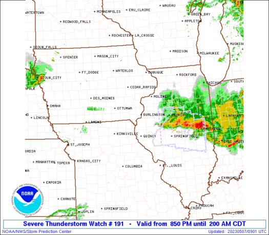
Severe Thunderstorm Watch Number 191
NWS Storm Prediction Center Norman OK
850 PM CDT Sat May 6 2023
The NWS Storm Prediction Center has issued a
* Severe Thunderstorm Watch for portions of
Southeast Iowa
Western and Northwest Illinois
Far Northeast Missouri
* Effective this Saturday night and Sunday morning from 850 PM
until 200 AM CDT.
* Primary threats include...
Scattered large hail and isolated very large hail events to 2
inches in diameter possible
Scattered damaging wind gusts to 70 mph possible
A tornado or two possible
SUMMARY...Strong to severe thunderstorms will continue to develop
across northeast Missouri and southeast Iowa and move into
western/northwest Illinois this evening.
The severe thunderstorm watch area is approximately along and 40
statute miles north and south of a line from 55 miles west northwest
of Burlington IA to 60 miles east southeast of Burlington IA. For a
complete depiction of the watch see the associated watch outline
update (WOUS64 KWNS WOU1).
PRECAUTIONARY/PREPAREDNESS ACTIONS...
REMEMBER...A Severe Thunderstorm Watch means conditions are
favorable for severe thunderstorms in and close to the watch area.
Persons in these areas should be on the lookout for threatening
weather conditions and listen for later statements and possible
warnings. Severe thunderstorms can and occasionally do produce
tornadoes.
&&
OTHER WATCH INFORMATION...CONTINUE...WW 189...WW 190...
AVIATION...A few severe thunderstorms with hail surface and aloft to
2 inches. Extreme turbulence and surface wind gusts to 60 knots. A
few cumulonimbi with maximum tops to 500. Mean storm motion vector
27025.
...Guyer
 Note:
The Aviation Watch (SAW) product is an approximation to the watch area.
The actual watch is depicted by the shaded areas.
Note:
The Aviation Watch (SAW) product is an approximation to the watch area.
The actual watch is depicted by the shaded areas.
SAW1
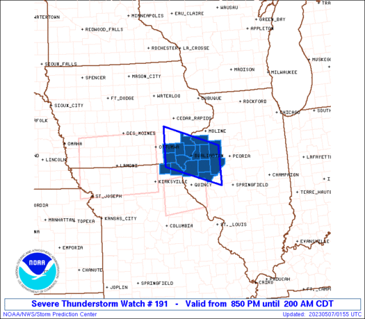
WW 191 SEVERE TSTM IA IL MO 070150Z - 070700Z
AXIS..40 STATUTE MILES NORTH AND SOUTH OF LINE..
55WNW BRL/BURLINGTON IA/ - 60ESE BRL/BURLINGTON IA/
..AVIATION COORDS.. 35NM N/S /35SW IOW - 48SSW BDF/
HAIL SURFACE AND ALOFT..2 INCHES. WIND GUSTS..60 KNOTS.
MAX TOPS TO 500. MEAN STORM MOTION VECTOR 27025.
LAT...LON 41669211 41029008 39869008 40509211
THIS IS AN APPROXIMATION TO THE WATCH AREA. FOR A
COMPLETE DEPICTION OF THE WATCH SEE WOUS64 KWNS
FOR WOU1.
Watch 191 Status Report Messages:
STATUS REPORT #5 ON WW 191

VALID 070645Z - 070700Z

SEVERE WEATHER THREAT CONTINUES RIGHT OF A LINE FROM 30 SE OTM TO
35 W MLI.


PARTS OF REMAINING VALID PORTION OF WW MAY BE LOCALLY EXTENDED AN
HOUR OR TWO.  OTHERWISE, IT IS NOT YET CLEAR ANOTHER WATCH WILL BE
NEEDED.

..KERR..05/07/23

ATTN...WFO...DVN...ILX...

&&

STATUS REPORT FOR WS 191

SEVERE WEATHER THREAT CONTINUES FOR THE FOLLOWING AREAS

ILC057-067-071-095-109-131-169-187-070700-

IL
.    ILLINOIS COUNTIES INCLUDED ARE

FULTON		     HANCOCK		 HENDERSON
KNOX		     MCDONOUGH		 MERCER
SCHUYLER	     WARREN
$$


IAC057-087-111-177-070700-

IA
.    IOWA COUNTIES INCLUDED ARE

DES MOINES	     HENRY		 LEE
VAN BUREN
$$


MOC045-199-070700-

MO
.    MISSOURI COUNTIES INCLUDED ARE

CLARK		     SCOTLAND
$$


THE WATCH STATUS MESSAGE IS FOR GUIDANCE PURPOSES ONLY.  PLEASE
REFER TO WATCH COUNTY NOTIFICATION STATEMENTS FOR OFFICIAL
INFORMATION ON COUNTIES...INDEPENDENT CITIES AND MARINE ZONES
CLEARED FROM SEVERE THUNDERSTORM AND TORNADO WATCHES.
$$

STATUS REPORT #4 ON WW 191

VALID 070545Z - 070640Z

SEVERE WEATHER THREAT CONTINUES RIGHT OF A LINE FROM 25 SE OTM TO
35 W MLI.

..KERR..05/07/23

ATTN...WFO...DVN...ILX...

&&

STATUS REPORT FOR WS 191

SEVERE WEATHER THREAT CONTINUES FOR THE FOLLOWING AREAS

ILC057-067-071-095-109-131-169-187-070640-

IL
.    ILLINOIS COUNTIES INCLUDED ARE

FULTON		     HANCOCK		 HENDERSON
KNOX		     MCDONOUGH		 MERCER
SCHUYLER	     WARREN
$$


IAC057-087-111-177-070640-

IA
.    IOWA COUNTIES INCLUDED ARE

DES MOINES	     HENRY		 LEE
VAN BUREN
$$


MOC045-199-070640-

MO
.    MISSOURI COUNTIES INCLUDED ARE

CLARK		     SCOTLAND
$$


THE WATCH STATUS MESSAGE IS FOR GUIDANCE PURPOSES ONLY.  PLEASE
REFER TO WATCH COUNTY NOTIFICATION STATEMENTS FOR OFFICIAL
INFORMATION ON COUNTIES...INDEPENDENT CITIES AND MARINE ZONES
CLEARED FROM SEVERE THUNDERSTORM AND TORNADO WATCHES.
$$

STATUS REPORT #3 ON WW 191

VALID 070435Z - 070540Z

SEVERE WEATHER THREAT CONTINUES RIGHT OF A LINE FROM 25 SE OTM TO
35 W MLI.

..GOSS..05/07/23

ATTN...WFO...DVN...ILX...

&&

STATUS REPORT FOR WS 191

SEVERE WEATHER THREAT CONTINUES FOR THE FOLLOWING AREAS

ILC057-067-071-095-109-131-169-187-070540-

IL
.    ILLINOIS COUNTIES INCLUDED ARE

FULTON		     HANCOCK		 HENDERSON
KNOX		     MCDONOUGH		 MERCER
SCHUYLER	     WARREN
$$


IAC057-087-111-177-070540-

IA
.    IOWA COUNTIES INCLUDED ARE

DES MOINES	     HENRY		 LEE
VAN BUREN
$$


MOC045-199-070540-

MO
.    MISSOURI COUNTIES INCLUDED ARE

CLARK		     SCOTLAND
$$


THE WATCH STATUS MESSAGE IS FOR GUIDANCE PURPOSES ONLY.  PLEASE
REFER TO WATCH COUNTY NOTIFICATION STATEMENTS FOR OFFICIAL
INFORMATION ON COUNTIES...INDEPENDENT CITIES AND MARINE ZONES
CLEARED FROM SEVERE THUNDERSTORM AND TORNADO WATCHES.
$$

STATUS REPORT #2 ON WW 191

VALID 070340Z - 070440Z

SEVERE WEATHER THREAT CONTINUES RIGHT OF A LINE FROM 25 SE OTM TO
35 W MLI.

..GOSS..05/07/23

ATTN...WFO...DVN...ILX...

&&

STATUS REPORT FOR WS 191

SEVERE WEATHER THREAT CONTINUES FOR THE FOLLOWING AREAS

ILC057-067-071-095-109-131-169-187-070440-

IL
.    ILLINOIS COUNTIES INCLUDED ARE

FULTON		     HANCOCK		 HENDERSON
KNOX		     MCDONOUGH		 MERCER
SCHUYLER	     WARREN
$$


IAC057-087-111-177-070440-

IA
.    IOWA COUNTIES INCLUDED ARE

DES MOINES	     HENRY		 LEE
VAN BUREN
$$


MOC045-199-070440-

MO
.    MISSOURI COUNTIES INCLUDED ARE

CLARK		     SCOTLAND
$$


THE WATCH STATUS MESSAGE IS FOR GUIDANCE PURPOSES ONLY.  PLEASE
REFER TO WATCH COUNTY NOTIFICATION STATEMENTS FOR OFFICIAL
INFORMATION ON COUNTIES...INDEPENDENT CITIES AND MARINE ZONES
CLEARED FROM SEVERE THUNDERSTORM AND TORNADO WATCHES.
$$

STATUS REPORT #1 ON WW 191

VALID 070250Z - 070340Z

SEVERE WEATHER THREAT CONTINUES RIGHT OF A LINE FROM 25 SE OTM TO
35 W MLI.

..LYONS..05/07/23

ATTN...WFO...DVN...ILX...

&&

STATUS REPORT FOR WS 191

SEVERE WEATHER THREAT CONTINUES FOR THE FOLLOWING AREAS

ILC057-067-071-095-109-131-169-187-070340-

IL
.    ILLINOIS COUNTIES INCLUDED ARE

FULTON		     HANCOCK		 HENDERSON
KNOX		     MCDONOUGH		 MERCER
SCHUYLER	     WARREN
$$


IAC057-087-111-177-070340-

IA
.    IOWA COUNTIES INCLUDED ARE

DES MOINES	     HENRY		 LEE
VAN BUREN
$$


MOC045-199-070340-

MO
.    MISSOURI COUNTIES INCLUDED ARE

CLARK		     SCOTLAND
$$


THE WATCH STATUS MESSAGE IS FOR GUIDANCE PURPOSES ONLY.  PLEASE
REFER TO WATCH COUNTY NOTIFICATION STATEMENTS FOR OFFICIAL
INFORMATION ON COUNTIES...INDEPENDENT CITIES AND MARINE ZONES
CLEARED FROM SEVERE THUNDERSTORM AND TORNADO WATCHES.
$$
Note:
Click for Complete Product Text.
Tornadoes
Probability of 2 or more tornadoes
|
Low (20%)
|
Probability of 1 or more strong (EF2-EF5) tornadoes
|
Low (10%)
|
Wind
Probability of 10 or more severe wind events
|
Mod (40%)
|
Probability of 1 or more wind events > 65 knots
|
Low (20%)
|
Hail
Probability of 10 or more severe hail events
|
Mod (40%)
|
Probability of 1 or more hailstones > 2 inches
|
Mod (30%)
|
Combined Severe Hail/Wind
Probability of 6 or more combined severe hail/wind events
|
High (80%)
|
For each watch, probabilities for particular events inside the watch
(listed above in each table) are determined by the issuing forecaster.
The "Low" category contains probability values ranging from less than 2%
to 20% (EF2-EF5 tornadoes), less than 5% to 20% (all other probabilities),
"Moderate" from 30% to 60%, and "High" from 70% to greater than 95%.
High values are bolded and lighter in color to provide awareness of
an increased threat for a particular event.


 @NWSSPC


