 Note:
The expiration time in the watch graphic is amended if the watch is
replaced, cancelled or extended.
Note:
Note:
The expiration time in the watch graphic is amended if the watch is
replaced, cancelled or extended.
Note: Click for
Watch Status Reports.
SEL1
URGENT - IMMEDIATE BROADCAST REQUESTED
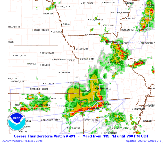
Severe Thunderstorm Watch Number 491
NWS Storm Prediction Center Norman OK
135 PM CDT Fri Jul 14 2023
The NWS Storm Prediction Center has issued a
* Severe Thunderstorm Watch for portions of
Extreme eastern Kansas
Western Missouri
* Effective this Friday afternoon and evening from 135 PM until
700 PM CDT.
* Primary threats include...
Scattered damaging winds and isolated significant gusts to 85
mph likely
Scattered large hail likely with isolated very large hail events
to 2 inches in diameter possible
A tornado or two possible
SUMMARY...A fast-moving line of severe thunderstorms will move east
across the watch area this afternoon and evening. Damaging winds,
possibly up to 85 mph, will be the primary severe weather risk.
Large hail will also be possible, in addition to a tornado or two
with embedded circulations along the leading edge of storms.
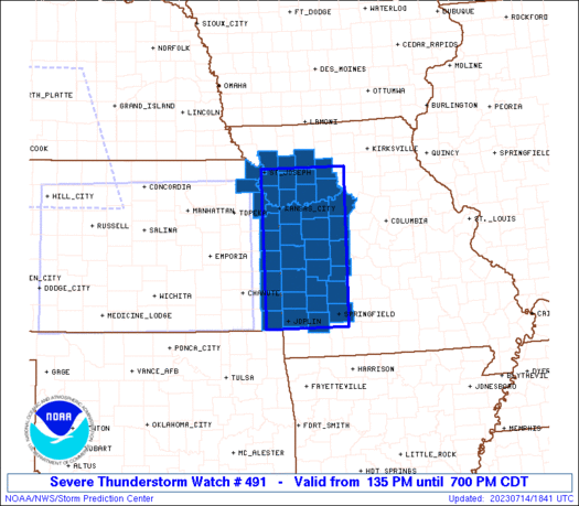
The severe thunderstorm watch area is approximately along and 50
statute miles east and west of a line from 25 miles west of
Chillicothe MO to 25 miles east southeast of Joplin MO. For a
complete depiction of the watch see the associated watch outline
update (WOUS64 KWNS WOU1).
PRECAUTIONARY/PREPAREDNESS ACTIONS...
REMEMBER...A Severe Thunderstorm Watch means conditions are
favorable for severe thunderstorms in and close to the watch area.
Persons in these areas should be on the lookout for threatening
weather conditions and listen for later statements and possible
warnings. Severe thunderstorms can and occasionally do produce
tornadoes.
&&
OTHER WATCH INFORMATION...CONTINUE...WW 489...WW 490...
AVIATION...A few severe thunderstorms with hail surface and aloft to
2 inches. Extreme turbulence and surface wind gusts to 75 knots. A
few cumulonimbi with maximum tops to 550. Mean storm motion vector
29035.
...Bunting
   SEL1

   URGENT - IMMEDIATE BROADCAST REQUESTED
   Severe Thunderstorm Watch Number 491
   NWS Storm Prediction Center Norman OK
   135 PM CDT Fri Jul 14 2023

   The NWS Storm Prediction Center has issued a

   * Severe Thunderstorm Watch for portions of
     Extreme eastern Kansas
     Western Missouri

   * Effective this Friday afternoon and evening from 135 PM until
     700 PM CDT.

   * Primary threats include...
     Scattered damaging winds and isolated significant gusts to 85
       mph likely
     Scattered large hail likely with isolated very large hail events
       to 2 inches in diameter possible
     A tornado or two possible

   SUMMARY...A fast-moving line of severe thunderstorms will move east
   across the watch area this afternoon and evening.  Damaging winds,
   possibly up to 85 mph, will be the primary severe weather risk.
   Large hail will also be possible, in addition to a tornado or two
   with embedded circulations along the leading edge of storms.

   The severe thunderstorm watch area is approximately along and 50
   statute miles east and west of a line from 25 miles west of
   Chillicothe MO to 25 miles east southeast of Joplin MO. For a
   complete depiction of the watch see the associated watch outline
   update (WOUS64 KWNS WOU1).

   PRECAUTIONARY/PREPAREDNESS ACTIONS...

   REMEMBER...A Severe Thunderstorm Watch means conditions are
   favorable for severe thunderstorms in and close to the watch area.
   Persons in these areas should be on the lookout for threatening
   weather conditions and listen for later statements and possible
   warnings. Severe thunderstorms can and occasionally do produce
   tornadoes.

   &&

   OTHER WATCH INFORMATION...CONTINUE...WW 489...WW 490...

   AVIATION...A few severe thunderstorms with hail surface and aloft to
   2 inches. Extreme turbulence and surface wind gusts to 75 knots. A
   few cumulonimbi with maximum tops to 550. Mean storm motion vector
   29035.

   ...Bunting
 Note:
The Aviation Watch (SAW) product is an approximation to the watch area.
The actual watch is depicted by the shaded areas.
Note:
The Aviation Watch (SAW) product is an approximation to the watch area.
The actual watch is depicted by the shaded areas.
   SAW1
   WW 491 SEVERE TSTM KS MO 141835Z - 150000Z
   AXIS..50 STATUTE MILES EAST AND WEST OF LINE..
   25W CDJ/CHILLICOTHE MO/ - 25ESE JLN/JOPLIN MO/
   ..AVIATION COORDS.. 45NM E/W /45NE MCI - 42WSW SGF/
   HAIL SURFACE AND ALOFT..2 INCHES. WIND GUSTS..75 KNOTS.
   MAX TOPS TO 550. MEAN STORM MOTION VECTOR 29035.

   LAT...LON 39829311 37009318 37009499 39829499

   THIS IS AN APPROXIMATION TO THE WATCH AREA.  FOR A
   COMPLETE DEPICTION OF THE WATCH SEE WOUS64 KWNS
   FOR WOU1.
Watch 491 Status Report Messages:
STATUS REPORT #3 ON WW 491

VALID 142255Z - 142340Z

SEVERE WEATHER THREAT CONTINUES RIGHT OF A LINE FROM 35 SW OJC TO
30 ESE OJC TO 30 SE MKC TO 30 NE MKC TO 25 ENE CDJ.

FOR ADDITIONAL INFORMATION SEE MESOSCALE DISCUSSION 1553

..WENDT..07/14/23

ATTN...WFO...EAX...SGF...

&&

STATUS REPORT FOR WS 491

SEVERE WEATHER THREAT CONTINUES FOR THE FOLLOWING AREAS

KSC011-021-037-107-142340-

KS
.    KANSAS COUNTIES INCLUDED ARE

BOURBON 	     CHEROKEE		 CRAWFORD
LINN
$$


MOC011-013-015-033-039-053-057-077-083-085-089-097-101-107-109-
159-167-177-185-195-217-142340-

MO
.    MISSOURI COUNTIES INCLUDED ARE

BARTON		     BATES		 BENTON
CARROLL 	     CEDAR		 COOPER
DADE		     GREENE		 HENRY
HICKORY 	     HOWARD		 JASPER
JOHNSON 	     LAFAYETTE		 LAWRENCE
PETTIS		     POLK		 RAY
ST. CLAIR	     SALINE		 VERNON
$$


THE WATCH STATUS MESSAGE IS FOR GUIDANCE PURPOSES ONLY.  PLEASE
REFER TO WATCH COUNTY NOTIFICATION STATEMENTS FOR OFFICIAL
INFORMATION ON COUNTIES...INDEPENDENT CITIES AND MARINE ZONES
CLEARED FROM SEVERE THUNDERSTORM AND TORNADO WATCHES.
$$

STATUS REPORT #2 ON WW 491

VALID 142055Z - 142140Z

SEVERE WEATHER THREAT CONTINUES RIGHT OF A LINE FROM 20 WSW FLV
TO 15 E STJ TO 20 ENE CDJ.

FOR ADDITIONAL INFORMATION SEE MESOSCALE DISCUSSION 1551

..GLEASON..07/14/23

ATTN...WFO...EAX...SGF...

&&

STATUS REPORT FOR WS 491

SEVERE WEATHER THREAT CONTINUES FOR THE FOLLOWING AREAS

KSC011-021-037-091-103-107-121-209-142140-

KS
.    KANSAS COUNTIES INCLUDED ARE

BOURBON 	     CHEROKEE		 CRAWFORD
JOHNSON 	     LEAVENWORTH	 LINN
MIAMI		     WYANDOTTE
$$


MOC011-013-015-021-025-033-037-039-047-049-057-077-083-085-095-
097-101-107-109-117-159-165-167-177-185-195-217-142140-

MO
.    MISSOURI COUNTIES INCLUDED ARE

BARTON		     BATES		 BENTON
BUCHANAN	     CALDWELL		 CARROLL
CASS		     CEDAR		 CLAY
CLINTON 	     DADE		 GREENE
HENRY		     HICKORY		 JACKSON
JASPER		     JOHNSON		 LAFAYETTE
LAWRENCE	     LIVINGSTON 	 PETTIS
PLATTE		     POLK		 RAY
ST. CLAIR	     SALINE		 VERNON
$$


THE WATCH STATUS MESSAGE IS FOR GUIDANCE PURPOSES ONLY.  PLEASE
REFER TO WATCH COUNTY NOTIFICATION STATEMENTS FOR OFFICIAL
INFORMATION ON COUNTIES...INDEPENDENT CITIES AND MARINE ZONES
CLEARED FROM SEVERE THUNDERSTORM AND TORNADO WATCHES.
$$

STATUS REPORT #1 ON WW 491

VALID 141955Z - 142040Z

THE SEVERE WEATHER THREAT CONTINUES ACROSS THE ENTIRE WATCH AREA.

FOR ADDITIONAL INFORMATION SEE MESOSCALE DISCUSSION 1547

..GLEASON..07/14/23

ATTN...WFO...EAX...SGF...

&&

STATUS REPORT FOR WS 491

SEVERE WEATHER THREAT CONTINUES FOR THE FOLLOWING AREAS

KSC005-011-021-037-043-091-103-107-121-209-142040-

KS
.    KANSAS COUNTIES INCLUDED ARE

ATCHISON	     BOURBON		 CHEROKEE
CRAWFORD	     DONIPHAN		 JOHNSON
LEAVENWORTH	     LINN		 MIAMI
WYANDOTTE
$$


MOC003-011-013-015-021-025-033-037-039-047-049-057-061-063-077-
083-085-095-097-101-107-109-117-159-165-167-177-185-195-217-
142040-

MO
.    MISSOURI COUNTIES INCLUDED ARE

ANDREW		     BARTON		 BATES
BENTON		     BUCHANAN		 CALDWELL
CARROLL 	     CASS		 CEDAR
CLAY		     CLINTON		 DADE
DAVIESS 	     DEKALB		 GREENE
HENRY		     HICKORY		 JACKSON
JASPER		     JOHNSON		 LAFAYETTE
LAWRENCE	     LIVINGSTON 	 PETTIS
PLATTE		     POLK		 RAY
ST. CLAIR	     SALINE		 VERNON
$$


THE WATCH STATUS MESSAGE IS FOR GUIDANCE PURPOSES ONLY.  PLEASE
REFER TO WATCH COUNTY NOTIFICATION STATEMENTS FOR OFFICIAL
INFORMATION ON COUNTIES...INDEPENDENT CITIES AND MARINE ZONES
CLEARED FROM SEVERE THUNDERSTORM AND TORNADO WATCHES.
$$
Note:
Click for Complete Product Text.
Tornadoes
Probability of 2 or more tornadoes
|
Low (20%)
|
Probability of 1 or more strong (EF2-EF5) tornadoes
|
Low (<2%)
|
Wind
Probability of 10 or more severe wind events
|
High (70%)
|
Probability of 1 or more wind events > 65 knots
|
Mod (60%)
|
Hail
Probability of 10 or more severe hail events
|
Mod (60%)
|
Probability of 1 or more hailstones > 2 inches
|
Mod (30%)
|
Combined Severe Hail/Wind
Probability of 6 or more combined severe hail/wind events
|
High (>95%)
|
For each watch, probabilities for particular events inside the watch
(listed above in each table) are determined by the issuing forecaster.
The "Low" category contains probability values ranging from less than 2%
to 20% (EF2-EF5 tornadoes), less than 5% to 20% (all other probabilities),
"Moderate" from 30% to 60%, and "High" from 70% to greater than 95%.
High values are bolded and lighter in color to provide awareness of
an increased threat for a particular event.


 @NWSSPC


